9:45 AM | ***Severe weather next three days…today’s threat TX-OK-to-KS…enhanced risk tomorrow centered over Lower/Middle MS Valley…threat shifts to east coast at mid-week***
Paul Dorian
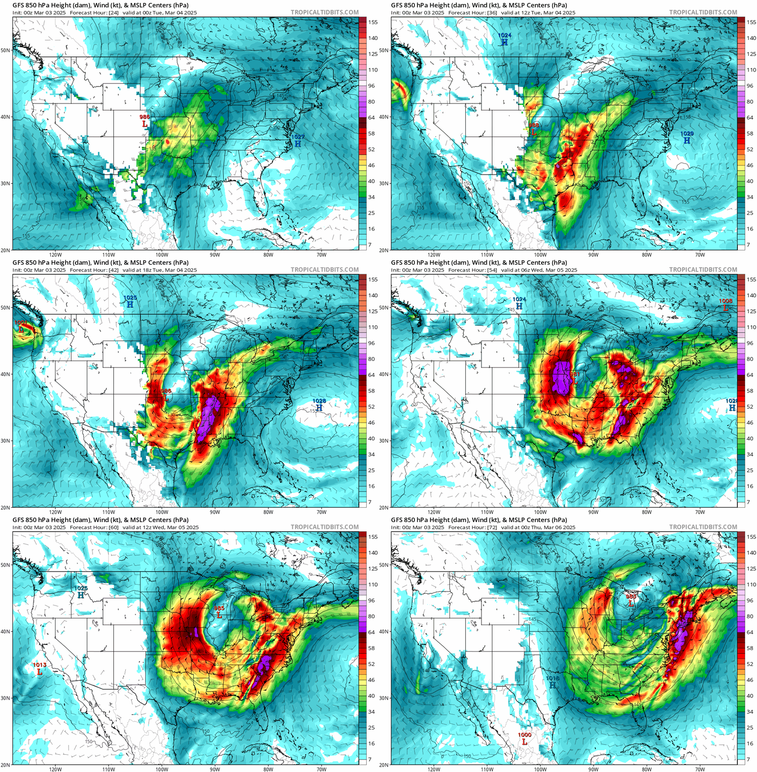
The main risk of severe weather over the next few days will be for damaging wind gusts though tornadoes are certainly on the table. A major contributing factor to the risk of damaging wind gusts will include very strong low-level winds which will last during the stretch from late today through Wednesday across the eastern half of the nation. Maps courtesy NOAA, tropicaltidbits.com
Overview
The month of March is now underway and it certainly can feature multiple severe weather outbreaks as the air becomes increasingly warm and humid across the southern states at the same time colder-than-normal air masses continue to push south and east from Canada into the US. The ingredients are falling into place for severe weather during each of the next three days as indeed colder-than-normal air from the western states will push eastward into a warmer-than-normal air mass that today will be centered over the central states. The main threat zone for severe weather today is likely to extend from Texas-to-Oklahoma-to-Kansas and then an enhanced risk is likely on Tuesday centered over the Lower and Middle Mississippi Valley region. Spring-like storm conditions will reach the eastern states on Wednesday with windy, warmer weather, soaking rainfall, and the potential of strong-to-severe thunderstorm activity.
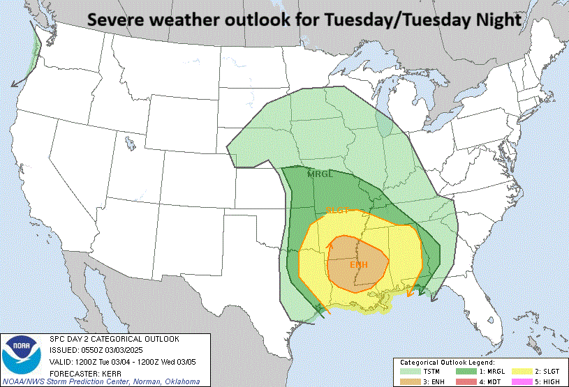
An enhanced risk of severe weather on Tuesday and Tuesday night will be centered over the Lower and Middle Mississippi Valley region. Map courtesy NOAA/SPC
Details
A strong Pacific Ocean storm system will slide eastward today reaching the eastern Plains of Colorado by later tonight where blizzard conditions are likely overnight with snow and wind gusts past 60 mph or so. This eastward-moving system will have an impact across the central Plains later today and tonight with an increasingly unstable atmosphere that is likely to produce severe thunderstorm activity; primary, in the region from Texas-to-Oklahoma-to-Kansas. The main threat in this area will be for damaging wind gusts, but a few tornadoes are certainly on the table across the heartland later today into tonight.
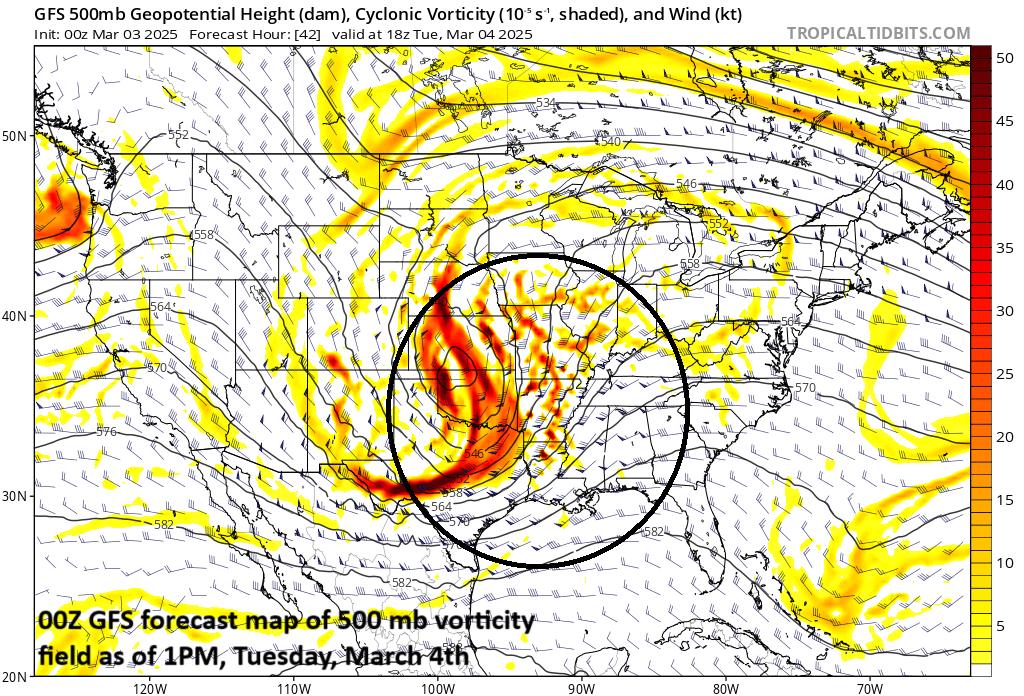
There will be an enhanced threat of severe weather on Tuesday/Tuesday night across the Lower and Middle Mississippi Valley region and a major contributing factor will be a vorticity maximum over the central US which will destabilize the atmosphere just out ahead of it. Map courtesy NOAA, tropicaltidbits.com
On Tuesday, the severe weather threat becomes even more significant and widespread with an “enhanced” risk across much of the Lower and Middle Mississippi Valley region from Louisiana-to-Mississippi-to-Alabama on the south side to Tennessee and Arkansas farther to the north. As in today’s scenario, damaging wind gusts are the main threat for severe weather on Tuesday aided by powerful low-level winds, but a few tornadoes are certainly possible as well in this part of the nation.
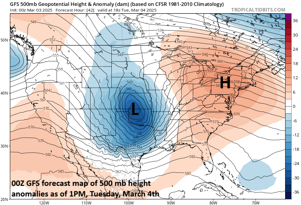
There will be an enhanced threat of severe weather on Tuesday/Tuesday night across the Lower and Middle Mississippi Valley region and contributing factors will include a strong upper-level low in the central US and high pressure ridging centered over the Mid-Atlantic region. Map courtesy NOAA, tropicaltidbits.com
By Wednesday, the spring-like storm system will reach the eastern part of the nation. It’ll become windy, warmer on Wednesday in the Mid-Atlantic region with a soaking (and beneficial) rainfall and there can be some strong-to-severe thunderstorm activity as well. The main risk of severe weather on Wednesday will be in the form of damaging wind gusts - aided by very strong low-level winds - and there can be isolated tornadoes as well; primarily, in the coastal region from the Delmarva Peninsula southward to the Carolinas.
One final note, given the fact that additional cold air outbreaks appear quite likely during the next few weeks, this month of March is likely to feature additional severe weather outbreaks as well.
Meteorologist Paul Dorian
Arcfield
arcfieldweather.com