10:45 AM | *Active weather pattern continues...severe weather threat focused today on the Middle Mississippi and Tennessee Valleys...shifts south and east on Thursday*
Paul Dorian

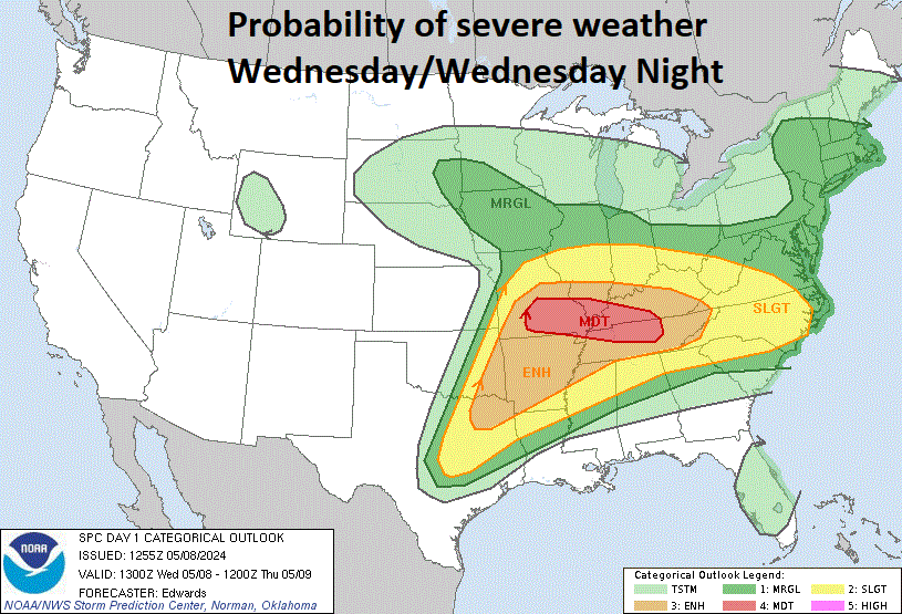
The highest probability of severe weather today will be across the Middle Mississippi and Tennessee Valleys with strong tornadoes on the table. Map courtesy NOAA/SPC
Overview
The overall weather pattern across the nation remains quite active as we push into the second week of May and this includes continuing threats of severe weather. Earlier this week, severe weather took place across Oklahoma and Texas with numerous tornadoes reported and the threat zone on Tuesday shifted to the Ohio Valley. Today’s greatest threat of severe weather will be focused on the Middle Mississippi and Tennessee Valleys and, once again, tornadoes will be on the table. The severe weather threat on Thursday will shift a bit to the east and south and likely extend all the way across the Gulf states from Texas-to-Georgia and up along the eastern seaboard to around the Delmarva Peninsula/southern New Jersey region.

The highest probability of severe weather on Thursday will be across the Gulf states and up along the Atlantic seaboard to the southern Mid-Atlantic. Map courtesy NOAA/SPC
Details
As April turned into May, the overall upper air wind pattern across North America that brought chilly air masses from Canada into the US remained fully intact. This trend has combined with increasingly warm and humid air masses flowing northward from the Gulf of Mexico resulting in numerous “battle zone” scenarios in the atmosphere - and numerous severe weather events. Earlier in the week, the “clash” zone was across Oklahoma and Texas, yesterday it shifted to the Ohio Valley, and today ingredients are coming together for the threat of severe weather across the Middle Mississippi and Tennessee Valleys.

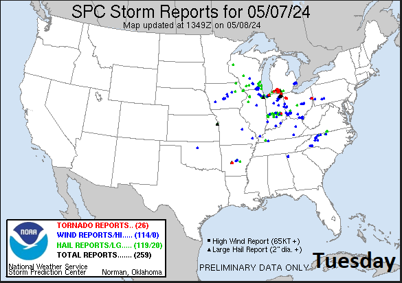
Numerous reports of severe weather took place across the nation’s mid-section on Monday, May 6th (data courtesy NOAA/SPC)
The threat today in the Mississippi and Tennessee Valleys will include all types of severe weather hazards from large hail-to-drenching rainfall-to-damaging wind gusts and potentially, it may include strong tornadic activity. Ingredients in the atmosphere that appear to be coming together for this increasing chance of severe weather include an upper-level low over the northern Plains, a series of amplifying shortwaves, and another wave in the southern part of the jet stream that is to move eastward later today from the Southwest US. In the low-level of the atmosphere, warm, humid air will flow northward from the Gulf of Mexico into the MS and TN Valley regions adding to the overall instability of the atmosphere.
Numerous reports of severe weather took place across the Ohio Valley on Tuesday, May 7th (data courtesy NOAA/SPC)
This threat of severe weather on Thursday will shift to the east and south and likely extend all the way across the southern states from Texas-to-Georgia and up along the eastern seaboard to the southern Mid-Atlantic. The threat of severe weather on Thursday may begin quite early in the day across portions of Georgia and South Carolinas as a “mesoscale convective complex” may pose a threat for damaging wind gusts in that part of the east. By the way, in this Gulf region from Texas-to-Georgia there is likely to be a ton of rainfall from later this week into early next week.

Accumulated value of maximum updraft helicity in the 2-5 km layer expressed in m**2/s**2 with highest levels depicted by the latest HRRR model run over the Tennessee valley region. This is a measure of the updraft rotation in a simulated storm. A value exceeding 25 m**2/s**2 suggests the potential for a storm to acquire rotation with higher values potentially suggesting tornado threat if the proper environment is in place. It is expressed as a color fill with a reference bar of values for each color located on the left side of the image. (Map courtesy NOAA/HRRR)
Meanwhile, farther to the north, the threat of severe weather will increase later tomorrow across portions of the Mid-Atlantic region as a cold front approaches the region and that threat may extend as far north as the region from DC-to-Delmarva Peninsula-to-southern New Jersey. Hail and damaging winds and perhaps even isolated tornadoes will be a concern across the southern Mid-Atlantic region from later tomorrow into tomorrow evening. Following the passage of the cold front, noticeably cooler conditions will prevail in the Mid-Atlantic for Friday, Saturday, and Sunday and it’ll remain somewhat unsettled with a continuing threat of showers.

Well below-normal temperatures will take place in the Mid-Atlantic/Northeast US during the period from Friday-to-Sunday. This forecast map of 850 millibar temperature anomalies is valid for Sunday morning, May 12th. Map courtesy NOAA, tropicaltidbits.com
Meteorologist Paul Dorian
Arcfield
arcfieldweather.com
Follow us on Facebook, Twitter, YouTube
Video discussion: