
10:45 AM (Wednesday) | ***Severe thunderstorms on the table in the Mid-Atlantic region from late today into tonight***
Paul Dorian

Showers and thunderstorms will break out in the Mid-Atlantic region later today and continue tonight and some of the storms can reach severe levels with the potential of damaging wind gusts, heavy rain, large hail, and even isolated tornadoes. Map courtesy NOAA, Pivotal Weather
Overview
Several ingredients will come together late today and tonight to raise the chance of severe thunderstorm activity in the Mid-Atlantic region. The combination of an approaching surface cool front, higher heat and humidity, a strong low-level jet, wind shear, and an upper-level trough will result in showers and thunderstorms from later today into tonight and any thunderstorm can reach severe levels. The severe weather threats include damaging wind gusts, heavy rainfall, and large hail. In addition, given the expected formation of strong wind shear, there will also be the potential of isolated tornadoes.

One severe weather parameter known as the “Convective Available Potential Energy (CAPE)” will be on the increase later today in the Mid-Atlantic region indicative of an increasingly unstable atmosphere and an enhanced chance of severe weather. Map courtesy NOAA, Pivotal Weather
Details
There were thunderstorms in the Mid-Atlantic region this past weekend – some of which were severe – but not everyone was impacted as they were scattered in nature. Those locations that were not hit by severe storms this past weekend will be threatened again from later today into tonight as a combination of ingredients in the atmosphere are expected to come together raising the chance of damaging wind gusts, heavy rain, large hail, and perhaps even isolated tornadoes.

Dew points will increase substantially today in the Mid-Atlantic region following a very dry day on Tuesday when dew points held in the upper 40’s and lower 50’s in the I-95 corridor. Map courtesy NOAA, Pivotal Weather
To begin, dew points are going to climb into the upper 60’s or lower 70’s by later today which is a far cry from yesterday’s unusually low (dry) levels ranging from the upper 40’s to lower 50’s across the I-95 corridor. (Dew point temperature is the truest measure of overall humidity...i.e., the higher the dew point, the higher the moisture content in the atmosphere). Another important factor later today will be the intensification of a low-level jet streak at 850 millibars which will increase the chance of wind shear in the atmosphere (i.e., a change of wind direction and speed with height). As such, given the expected increase in wind shear, isolated tornadoes may be part of the equation later today and tonight in the Mid-Atlantic region. Other ingredients that will add to instability include a surface cool front and an upper-level trough that will enhance upward motion in the Mid-Atlantic region.
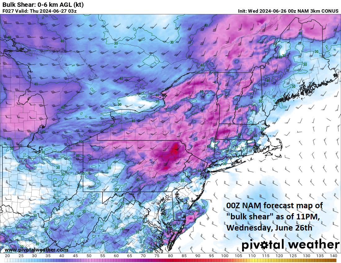
Wind shear will increase later today in the Mid-Atlantic region (i.e., a change of wind direction and speed with height) and this will enhance the chance of isolated tornadoes during this severe weather event. Map courtesy NOAA, Pivotal Weather
In terms of rainfall, any storm that forms later today will have the capability of producing heavy rainfall given the high amounts of available moisture and the expected lifting required in the atmosphere. The timetable for this potential severe weather event in the Mid-Atlantic’s I-95 corridor region is likely to be in the period from about 4 or 5 pm to midnight or 1am. The window is rather large as there can be multiple rounds of storms pushing over the same location from late afternoon to late evening. The surface cool front will move offshore early tomorrow morning paving the way for lowering humidity later in the day to go along with decreasing cloud cover.
Looking ahead, this same scenario in the Mid-Atlantic region featuring the threat of severe weather including isolated tornadoes may repeat on Saturday night and Sunday with the approach of another cool frontal system.
Meteorologist Paul Dorian
Arcfield
arcfieldweather.com
Follow us on Facebook, Twitter, YouTube
Video discussion: