
1:30 PM | ***Hurricane Beryl likely to attain “cat 5” status over the Caribbean Sea...a late turn to the NW?...an active Atlantic Basin...a quiet Pacific***
Paul Dorian

Hurricane Beryl has reached “cat 4” status with a well define eye and could climb to “cat 5” status over the Caribbean Sea within a day or so. Images courtesy NOAA/GOES-East
Overview
Hurricane Beryl is now moving across the southern Windward Islands and into the Caribbean Sea as a category 4 hurricane with maximum sustained winds of 140 mph. This system has a chance to intensify into category 5 status (sustained winds of 157 mph or higher) in the next day or two as it treks to the west-northwest over the warm waters of the Caribbean Sea. On this current track, Hurricane Beryl will move close to the island of Jamaica by mid-week and then likely reach the Yucatan Peninsula region of Mexico by the end of the week. After that, the likely scenario has a weakened Beryl moving west towards eastern Mexico; however, a turn towards the northwest and southeastern Texas cannot be ruled out later this weekend.

NOAA’s official forecast track places Hurricane Beryl just to the south of Jamaica at mid-week and then to a position over the Yucatan Peninsula by the end of the week. Map courtesy NOAA/NHC
Details
Hurricane Beryl has intensified rapidly during the past couple of days and became one of the strongest June hurricanes on record. (Hurricane Aubrey of 1957 may have had a lower central pressure than Beryl, but these are among the strongest during the month of June). This morning Hurricane Beryl went through an “eyewall replacement” cycle and the latest radar images feature a well-defined suggesting the cycle is complete leading to additional strengthening. The core of the cat 4 hurricane is nearing Carriacou Island, Grenada, and the Grenadine Islands as it treks at a pretty good clip (20 mph) to the west-northwest. By mid-week, hurricane conditions are possible in Jamaica as Beryl likely slides just to its south, but close enough for serios impact.

A shift aloft of the axis of high pressure ridging from mid-week over the interior US (left map) to a position over the western Atlantic this weekend (right map) may open the door for a turn to the northwest by Beryl and perhaps towards the state of Texas. Maps courtesy NOA, tropicaltidbits.com
After that, Hurricane Beryl is likely to cross over the Yucatan Peninsula region of Mexico on late Wednesday or so and this usually weakens tropical systems before entering the southwestern Gulf of Mexico. In fact, a slight weakening may take place with Beryl before that point while it treks over the central Caribbean and after perhaps reaching cat 5 status. Once Hurricane Beryl pushes into the southwestern Gulf of Mexico, it is likely to continue WNW towards eastern Mexico. However, a turn to the northwest - and perhaps to the state of Texas - cannot be ruled out as Beryl will become less influenced by high pressure ridging aloft that will shift east somewhat from its position at mid-week over the interior US to a location this weekend over the western Atlantic. Bottom line, all residents along the Texas coast (and Louisiana coast as well) should continue to monitor closely the movement of Hurricane Beryl during the remainder of this week.
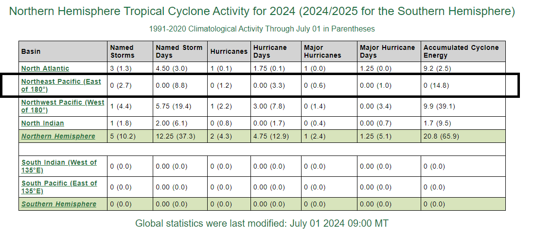
While the Atlantic Basin has come to life with well above-normal Accumulated Cyclone Energy (ACE, top line), activity in the eastern Pacific Ocean has been non-existent through June (boxed region) which is at historically low levels. Data courtesy NOAA, Colorado State University
Looking farther out into the Atlantic, there is another tropical system trailing Hurricane Beryl that is currently located in the eastern Atlantic. This system is likely to follow a similar path as Beryl towards and then across the Caribbean Sea, but its intensification prospects may be somewhat diminished. Overall environment conditions may become more hostile than has been the case with Beryl and sea surface temperatures in the Caribbean Sea may actually drop a bit after the passage of Beryl which could result in enough upwelling for cooler waters from underneath to rise up to the surface. Meanwhile, the eastern Pacific Ocean has been quiet all through the tropical season so far and if another couple of days pass by without any activity, it would become the latest start ever in that part of the world’s largest ocean.
Meteorologist Paul Dorian
Arcfield
arcfieldweather.com
Follow us on Facebook, Twitter, YouTube
Video discussion: