
2023 Tropical and Summer Outlook
2023 Tropical and Summer Outlook
2023 Tropical and Summer Outlook

Current sea surface temperature (SST) anomalies with El Nino (warmer-than-normal) conditions intensifying off the west coast of South America. Warmer-than-normal water prevails off the west coast of Africa as well in the far eastern part of the tropical Atlantic. Map courtesy CMC Environment Canada
Overview
Tropical activity is likely to be nearly normal this season in the Atlantic Basin with competing factors in the Atlantic and Pacific Oceans. In a normal Atlantic Basin tropical season, there are about 14 named storms, 7 hurricanes, and 3 of those actually attain “major” classification status (i.e., category 3 or higher on the Saffir-Simpson hurricane wind scale).
The major factors involved with this year’s tropical outlook include the development of El Nino in the equatorial Pacific Ocean which generally acts to suppress activity in the Atlantic Basin due to increased wind shear. The development of El Nino in the Pacific Ocean with warmer-than-normal sea surface temperatures comes after three years of La Nina conditions. Meanwhile, the Atlantic Ocean features plenty of warmer-than-normal water which is generally favorable for the development and/or intensification of tropical activity in the Atlantic Ocean, Caribbean Sea, and Gulf of Mexico. Indeed, the warmer-than-normal sea surface temperature pattern in the western Atlantic Ocean makes the east coast somewhat more vulnerable than normal to what I like to call “home-grown” tropical hits during this upcoming tropical season.
Executive Summary
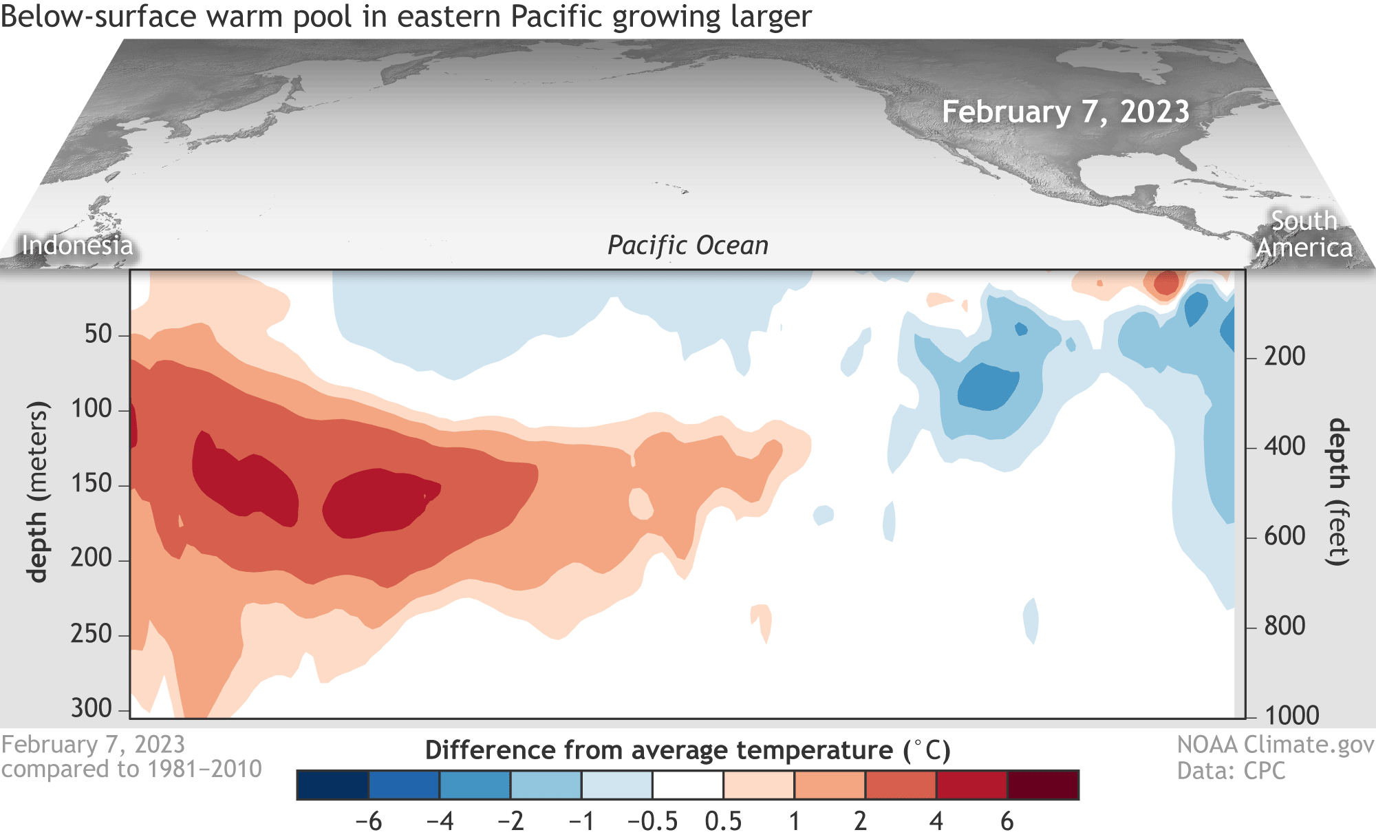
Water temperatures in the top 300 meters (1,000 feet) of the tropical Pacific Ocean compared to the 1991–2020 average in February–April 2023. NOAA Climate.gov animation, based on data from NOAA's Climate Prediction Center.
Nearly normal tropical activity this season in the Atlantic Basin
13-14 named storms, 6-7 hurricanes, 2-3 “major” hurricanes
The development of El Nino in the equatorial Pacific Ocean will play an important role
Generally unfavorable for tropical activity in the Atlantic Basin
Warmer-than-normal water in much of the Atlantic Basin
Generally favorable for tropical activity in the Atlantic Basin
US east coast vulnerable to “home grown” hits
An early start to the season is likely during the month of May over the Gulf of Mexico

“Names” to be designated for 2023 tropical storms/hurricanes
Recap of 2022 Tropical Season

The 2022 Atlantic hurricane season was the first season since 1997 in which no tropical cyclones formed in August, and the first season on record to do so during a La Nina year. It was a typical hurricane season with an average number of named storms, a slightly above-average number of hurricanes, a slightly below-average number of major hurricanes. The state of Florida was hit the hardest in the US during last year’s tropical season with direct hits just six weeks apart.
The 2022 Atlantic hurricane season was the first season since 1997 in which no tropical cyclones formed in August, and the first season on record to do so during a La Nina year. It was a typical hurricane season with an average number of named storms, a slightly above-average number of hurricanes, a slightly below-average number of major hurricanes. There were fourteen named storms during the season, eight of theses strengthened into a hurricane, and two reached major hurricane intensity (i.e., category 3 or higher). Eleven of the 14 storms, and all eight hurricanes, happened after August 31 in 2022.
Florida hard hit in 2022
Prior to late September 2022, the Florida Peninsula had gone five years since its last hurricane landfall according to wunderground.com, while the Panhandle had absorbed several strong hurricanes, including Category 5 Hurricane Michael. In 2022, that lucky streak came to a screeching halt in the Peninsula.
Hurricane Ian made landfall near Costa Cayo, Florida, or near Cape Coral at Category 4 intensity on September 28. In a bizarre coincidence, that happened to be the same exact landfall location as Category 4 Hurricane Charley in 2004. Ian inundated many Southwest Florida communities, including Fort Myers Beach and Sanibel Island, with more than 6 feet of storm surge. In Fort Myers, storm surge of at least 7 feet inundated normally dry ground, which shattered a record that had stood at nearly half of that. Winds gusted over 100 mph across Southwest Florida for hours. Ian’s highest recorded wind gust was 140 mph in Cape Coral. After landfall, Ian continued its widespread wrath of wind and water across Central Florida in a track nearly identical to Hurricane Charley’s track 18 years earlier.

The graph shows forecasts made by dynamical and statistical models for SST in the Nino 3.4 region for nine overlapping 3-month periods. Note that the expected skills of the models, based on historical performance, are not equal to one another. The skills also generally decrease as the lead time increases. Thirdly, forecasts made at some times of the year generally have higher skill than forecasts made at other times of the year--namely, they are better when made between June and December than when they are made between February and May. Differences among the forecasts of the models reflect both differences in model design, and actual uncertainty in the forecast of the possible future SST scenario. Map courtesy International Research Institute/CPC, NOAA, ECMWF
Just over a month later, Nicole transitioned from a typical late season subtropical storm into an uncommon November hurricane which then made the latest November mainland U.S. hurricane landfall since 1985. In another case of deja vu with the 2004 season, Nicole made landfall near Vero Beach and took a path similar to 2004’s Hurricane Jeanne, although Nicole was considerably weaker. Hurricane Nicole and a strong flow of northeast winds off the Atlantic Ocean produced massive beach erosion on Florida’s Space Coast and caused numerous beachside condos and some homes to dangle on several-foot-high cliffs looking over the Atlantic. Coastal roads, parking garages and some homes crumbled into the sea.
Detailed Analysis
El Nino in the Tropical Pacific Ocean

What goes on in the tropical Pacific Ocean does indeed have an effect on the tropical Atlantic Ocean. El Nino, which refers to warmer-than-normal surface water in the equatorial Pacific Ocean, affects global weather patterns and it tends to be an inhibiting factor for tropical storm formation or intensification in the Atlantic Basin. First, El Nino tends to produce faster-than-usual high-altitude winds over the tropical Atlantic Ocean and this increase in wind shear (change of wind speed with height) is hostile to the development of maintenance of tropical storms. In addition, El Nino tends to result in sinking motion over parts of the Atlantic Basin which too is hostile to tropical storms.

El Nino summers are often near normal or slightly cooler-than-normal in the Mid-Atlantic region and are usually wetter-than-normal. (El Nino temperature and precipitation plots courtesy BAMWX.com)
After three consecutive years with La Nina conditions dominating the scene in the tropical Pacific Ocean, El Nino has begun to form near the west coast of South America and it is predicted to intensify and spread westward into the summer season. In fact, signs point to its continuation of El Nino conditions throughout the upcoming summer tropical season and perhaps all the way into next winter. Numerous computer forecast models maintain the El Nino in the tropical Pacific through the summer and fall seasons at moderate strength.
Favorable Signals in Much of the Atlantic Basin for Enhanced Tropical Activity
Not only are equatorial Pacific Ocean sea surface temperature anomalies important in terms of potential tropical activity in the Atlantic Basin in a given season, but Atlantic Oceans water temperatures can have a major impact on atmospheric circulation and, in fact, more of a direct role in the likelihood for formation and intensification of tropical storms. Sea surface temperatures of >80°F are generally considered a requirement for the formation of tropical storms; therefore, above-normal sea surface temperatures are typically quite favorable for tropical storm formation and intensification as tropical waves trek westward in the trade winds from Africa’s west coast to the western Atlantic Ocean.
In recent weeks, there has been persistent warmer-than-normal water in the breeding grounds of the Atlantic Basin from the west coast of Africa to the Gulf of Mexico. These anomalous warm regions should aid in the development and intensification of tropical systems; especially, with respect to the “home-grown” type of system that can form relatively close to the US east and Gulf coasts.
Mid-Atlantic Outlook
As far as the Mid-Atlantic region is concerned for the upcoming summer season, I believe it is likely to turn out to be wetter-than-normal with nearly normal-to-slightly above-normal overall temperatures. In terms of specifics, I expect the summer season will average out from nearly normal to perhaps as much as 1.0 degree (F) above-normal in the Mid-Atlantic region. While the current soil moisture conditions in the Mid-Atlantic region are on the low (dry) side which would enhance chances for hot, summer weather, I believe a much wetter weather pattern will evolve during the next several weeks bringing conditions back to normal by the summer. In terms of precipitation anomalies, the Mid-Atlantic region should average 1.0-2.0 inches above-normal per month during the summer season. Elsewhere, the summer season of 2023 should feature cooler and wetter conditions across much of the central/northern Plains and Midwest and a “drying out” period for much of the western US.