
Image of the week
Interesting Images from Around the Universe
Stunning images captured on earth or from space
Image of the Week


Use the form on the right to contact us.
You can edit the text in this area, and change where the contact form on the right submits to, by entering edit mode using the modes on the bottom right.
123 Street Avenue, City Town, 99999
(123) 555-6789
email@address.com
You can set your address, phone number, email and site description in the settings tab.
Link to read me page with more information.
Interesting Images from Around the Universe
Stunning images captured on earth or from space
Showers and thunderstorms rolled through the Washington, D.C. metro region on Friday night, June 12th, causing a 2 hour and 11 minute delay in the game between the Seattle Mariners and Washington Nationals. The game began around 8:56 pm on Friday night - shortly after sunset - and the skies turned a brilliant orange and a double rainbow could be seen at the Nationals Park. The game didn’t turn out too well for the Nats as they were defeated by the Mariners in a 10-2 ballgame. (Photo courtesy Capital Weather, X (Alex Warofka)).
An Artemis II rocket successfully launched a crew of four from Kennedy Space Center in Florida on Wednesday evening, April 1st, in a mission to fly around the far side of the moon in a maneuver reminiscent of Apollo 8 in 1968.
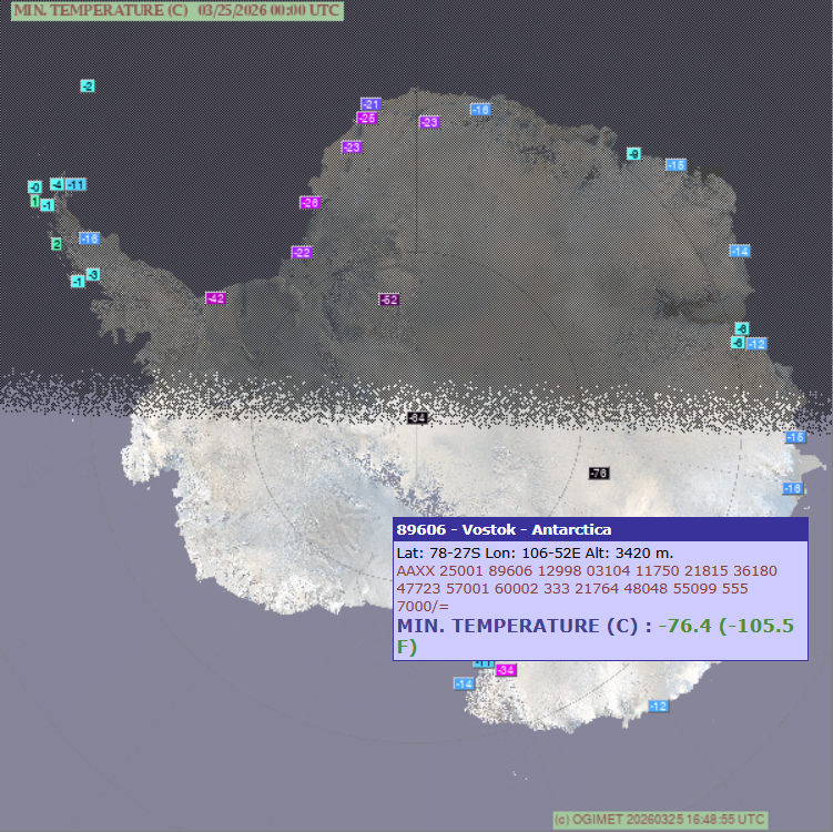
Vostok Station, Antarctica just set an all-time worldwide record cold temperature for the month of March at -105.5°F.
After traveling for 9 years, 5 months and 27 days, the New Horizons spacecraft flew past Pluto and captured this image.
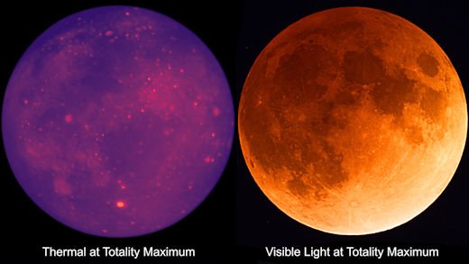
The total lunar eclipse on March 3rd, 2026 provided an opportunity to view “hot” spots as revealed by comparing a “thermal” image versus “visible”. When the Earth’s shadow crosses the moon during an eclipse, the sunlight is turned off, and some parts of the lunar surface cool faster than others. The areas that hang on to their warmth longer than their surroundings appear as “hot” spots. Fine moondust areas on the surface tend to cool quite rapidly whereas fresh blocky craters can hang on to their warmth for a longer period of time and appear as “hot” spots. (Courtesy spaceweather.com)
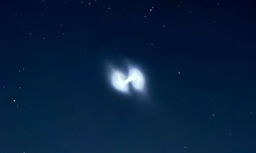
Many saw this on Tuesday night, August 12th, in the eastern US as they were looking for Perseid meteors…according to spaceweather.com,
“this is probably a fuel dump linked to a Vulcan Centaur rocket launched from Cape Canaveral by the United Launch Alliance (ULA). Carrying two satellites on behalf of the U.S. military, the rocket lifted off at 8:56 p.m. EDT on Aug. 12th (0056 GMT on Aug. 13th). When multiple satellites are deployed from a single rocket, the rocket sometimes spins to help the payloads go in different directions. That could account for the spiral shape of the exhaust.”
Severe weather threats have continued into the late spring across much of the nation as we have had numerous clashes between colder-than-normal air masses and warm, humid air. On Monday, June 16th, this clash in the atmosphere resulted in numerous damaging wind and hail reports across the state of Nebraska and there was at least one tornado reported. This photograph was taken in Wellfleet which is located in the southwestern part of Nebraska. The threat for severe weather will continue today, Tuesday, June 17th, across the nation’s mid-section including again the state of Nebraska and Kansas and Oklahoma as well.
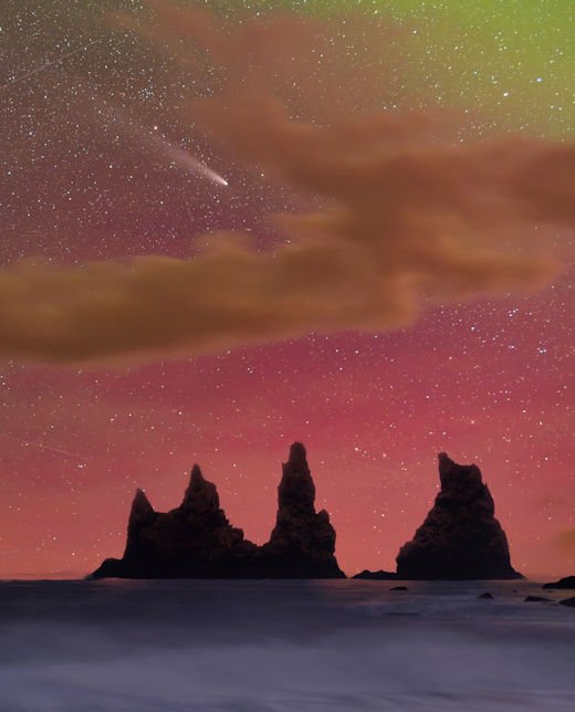
Comet Tsuchinshan-ATLAS has faded since its urban-bright display in mid-October, but it is still a great target for night sky photographers. Wioleta Gorecka photographed the comet on Oct. 26th, 2024 from Vik, Iceland at the same time auroras were coloring the nighttime sky in the Arctic Circle with pinks and red (courtesy spaceweather.com).
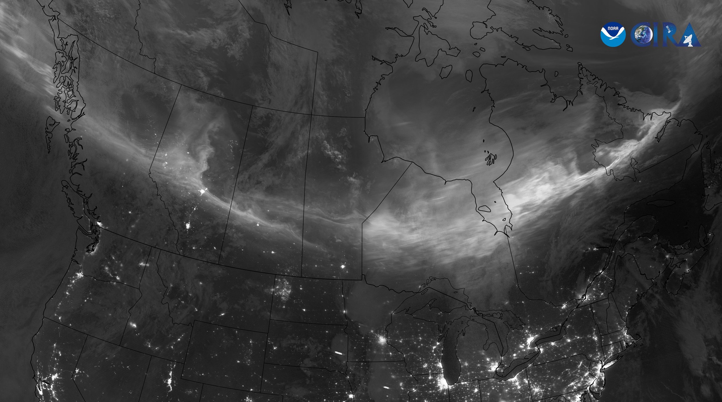
A geomagnetic storm reached Earth on Tuesday night, July 30th, leading to the appearance of the northern lights over Canada. JPSS satellites utilized the "day/night" band to capture the aurora borealis seen in this composite image. Credit: NOAA/CIRA
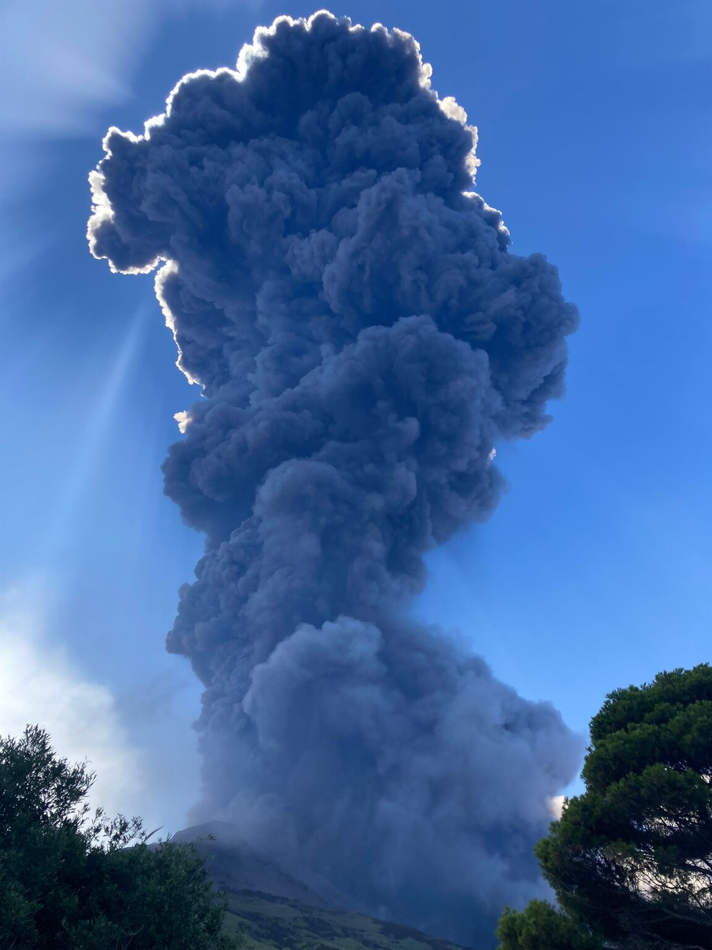
A very strong explosion occurred from the Stromboli volcano in Sicily on Thursday, July 11th and a massive ash plume rose from the summit area and drifted over the southeastern part of the island. Stromboli is one of the most active volcanoes in the world – renowned for its regular, but normally minor, eruptions that send lava oozing from vents inside its crater. It has been active for thousands of years. The minor eruptions which are often visible from the island and surrounding sea have given rise to its nickname of the “Lighthouse of the Mediterranean.” Credit Image: Francesca Utano, volcanodiscovery.com
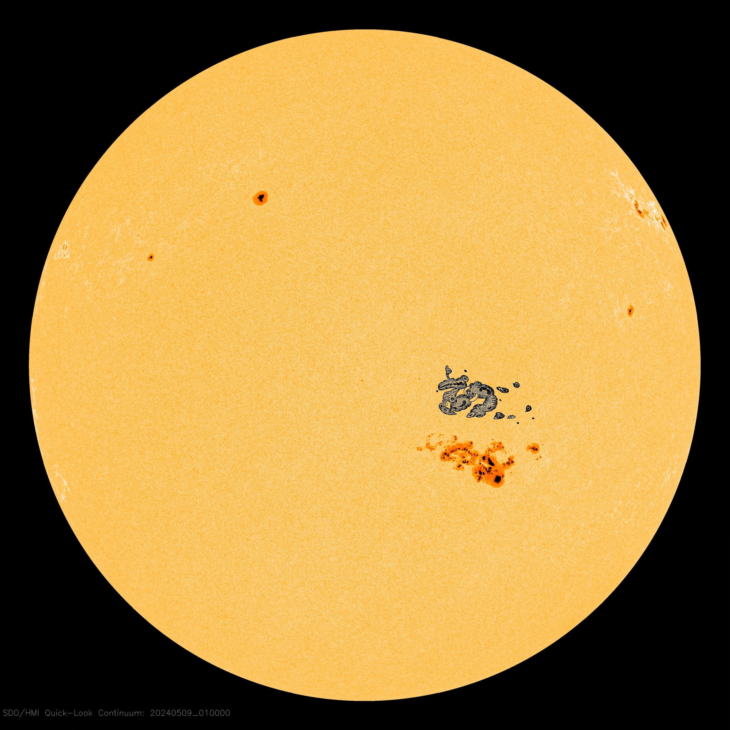
A very large sunspot region unleashed a series of coronal mass ejections (CMEs) that impacted the Earth's atmosphere on Friday night and Saturday (May 10th/11th, 2024). In fact, this was one of the strongest solar storms in many years and it resulted in northern lights being visible in some unusual places such as Mexico and Puerto Rico.
Kyle Nulla Cognomen sends this picture from Las Vegas, Nevada. "What a gorgeous view of the desert sky illuminated by aurora," he says. "I could see the reds and greens with my naked eye!" {Courtesy spaceweather.com}
Sunspot AR3664 has grown so large, it now rivals the great Carrington sunspot of 1859. To illustrate their similarity, spaceweather.com has added Carrington's famous sketch (to scale) to a NASA photo of today's sun. Sprawling almost 200,000 km from end to end, AR3664 is 15 times wider than Earth.
On September 1st, 1859, a ferocious solar storm took place that impacted much of the planet. This ferocious solar storm is now known as the “Carrington Event”, named after the British astronomer, Richard Carrington, who witnessed the largest solar flare from his own private observatory which caused a major coronal mass ejection (CME) to travel directly toward Earth.
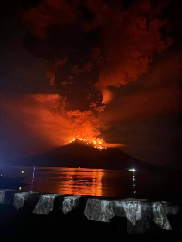
Hundreds of people in Indonesia had to be evacuated from their homes in the North Sulawesi province as the Ruang volcano continues its days-long eruption. The volcano has been seen filling the sky with red ash as the country's volcano monitoring agency reports hundreds of deep volcanic earthquakes. Indonesia's National Agency for Disaster Countermeasure, known as BNPB, said in a news release on Wednesday that volcanic activity has increased, prompting officials to raise the alert level to three – the second-highest warning level in their monitoring system. Video taken by the agency showing massive red bursts filling the sky as lightning flashes within it. (Photo courtesy Mark Margavage, X; news info courtesy CBS)
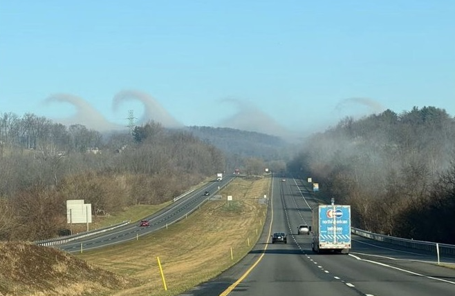
These wave clouds were created by an atmospheric phenomenon known as Kelvin-Helmholtz instability and were seen over the Catoctin Mountains in northern Maryland on Sunday, March 3rd, 2024. (Photo courtesy Joe Bastardi, Twitter)
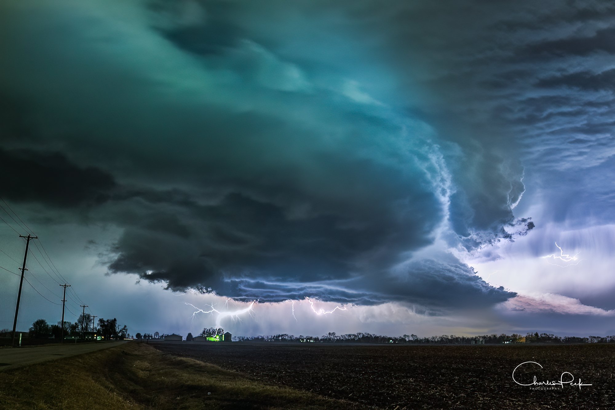
A photograph of a “tornado warned” supercell in Yorkville, Illinois on Tuesday evening, February 27th, 2024. Severe weather broke out across northern Illinois just ahead of a powerful cold frontal system. Photo courtesy Charles Peek (Twitter)
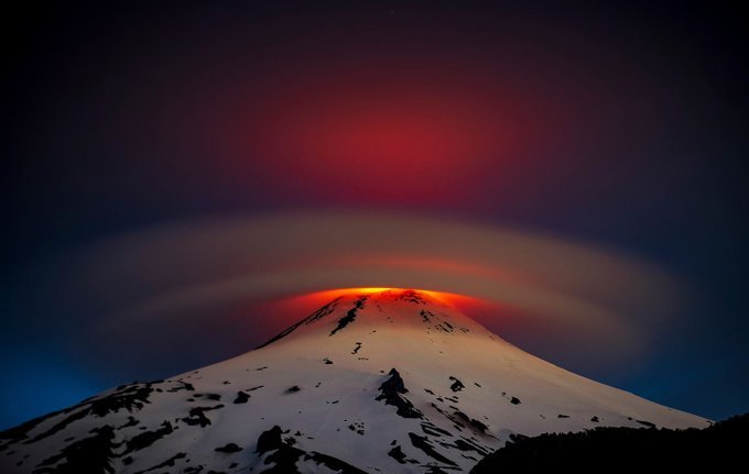
Villarrica is one of Chile's most active volcanoes; eruptions have been recorded since the conquest of Chile and the founding of the city of Villarrica in 1552. This image of a perfect lenticular cloud over the top of the volcano was taken during the middle of October (2023).