Contact Us

Use the form on the right to contact us.

You can edit the text in this area, and change where the contact form on the right submits to, by entering edit mode using the modes on the bottom right. 


123 Street Avenue, City Town, 99999

(123) 555-6789

email@address.com


You can set your address, phone number, email and site description in the settings tab.
Link to read me page with more information.

backlit-stratus-clouds-2013-04-05.jpg

Blog

Weather forecasting and analysis, space and historic events, climate information

Filtering by Category: Climate Info

12:30 PM | Southern hemisphere sea ice areal extent reaches record high in satellite era; northern hemisphere continues at well below normal levels, but above the low point set two years ago

Paul Dorian

antarctica[Yellow line represents 2014 southern hemisphere sea ice areal extent; courtesy University of Illinois "cryosphere" and NOAA/NCEP]

Discussion

Overall Summary The amazing recent expansion of Southern Hemisphere sea ice areal extent has continued and it has just reached an all-time high in the satellite data era which began 35 years ago in 1979 (above). This is the time of year when the southern hemisphere usually reaches its highest extent for the year (i.e., just ended their winter season) and the high for this year has also surpassed the all-time high during the past 35 years of record-keeping. The northern hemisphere sea ice areal extent – now near the low point of the year (i.e., just ended their summer season) - continues at well below normal levels, but it is above levels seen two years ago which were the lowest minimum amounts recorded since 1979. Overall, given the recent surge in the southern hemisphere to record levels, the global sea ice areal extent has spiked into “above-normal” territory (below).

global_sea_ice [red line represents 2014 global sea ice areal extent relative to normal at zero line; courtesy University of Illinois "cryosphere" and NOAA/NCEP]

Southern Hemisphere Sea Ice The remarkable period of increasing sea ice areal extent in this part of the world has actually been occurring for the past few years with only a few brief exceptions to that overall upward trend. Back in 2011, the southern hemisphere sea ice areal extent was at below-normal levels, but it is currently running nearly 1.7 million square kilometers above the 1979-2008 mean (courtesy University of Illinois "cryosphere" web site with data originating from NOAA/NCEP Snow and Ice Data Center).

Northern Hemisphere Sea Ice The northern hemisphere sea ice areal extent is still well below normal relative to all years going back to 1979 although it is noticeably above the lowest point set two years ago at this same time of year (plot below). The northern hemisphere sea ice areal extent is about 1.2 million square kilometers below normal using the base period of 1979-2008 for comparison. The northern hemisphere sea ice areal extent has generally trended lower since the mid 1990’s reaching primarily below-normal levels after the turn of the century. In the past several years, however, there has been a leveling off of that downward trend in terms of sea ice areal extent at those below-normal levels.

In the time period before the mid 1990’s, the sea ice extent was generally above-normal dating back to 1979. The directional shift in trendline that developed during the mid 1990’s in the northern hemisphere correlates quite well with a northern Atlantic Ocean sea surface temperature cycle that is tracked by meteorologists through an index called the Atlantic Multidecadal Oscillation (AMO). Indeed, the Atlantic Ocean has a significant impact on northern hemisphere sea ice areal extent and the AMO index flipped in phase during the mid 1990’s from negative (cold) to positive (warm) and the trend changed direction at that point in time. Once the northern Atlantic sea surface temperatures flip back to cooler-than-normal values – perhaps in the next few years - the northern hemisphere sea ice areal extent should return to the normal or above-normal levels seen prior to the mid 1990’s.

arctic [Yellow line represents 2014 northern hemisphere sea ice areal extent; courtesy University of Illinois "cryosphere" and NOAA/NCEP]

10:45 AM | Hottest August ever...not so fast according to satellite observations

Paul Dorian

Discussion

Overview NASA’s Goddard Institute of Space Studies (GISS) released a report earlier this week suggesting that August was the hottest August ever recorded on a global basis in its 134 years of record keeping dating back to the year 1880 (actually the initial report was quickly revised by NASA making it the second hottest August ever in their dataset). The global temperature anomaly map (below) from NASA displays the global temperature anomalies for August 2014 versus the 1981-2010 averages with the overall anomaly calculated at +0.31°C. The “yellow/orange/red” areas on the map represent those areas with temperatures above the 1981-2010 averages and the “blue/purple” regions experienced below average temperatures. Other datasets, however, which rely primarily on satellite observations for temperatures as compared to thermometer-based measurements, show a strikingly different story with respect to where August 2014 stands historically in terms of August global temperature anomalies.
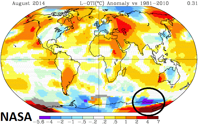
NASA August_using_1981-2010 [NASA global temperature anomalies for August 2014]

NASA’s GCHN and ERSST dataset and some known problems The NASA global land and ocean temperature anomalies are a merged product of the Global Historical Climatology Network (GCHN) which relies on ground-level thermometer-based temperature measurements from 6000 weather stations around the world and the Extended Reconstructed Sea Surface Temperatures (ERSST) for ocean temperatures. There are some known problems associated with thermometer-based datasets that include poor data coverage in significant portions of the polar regions and also the need for data “adjustments” at many weather stations in order to eliminate urban heat island (UHI) effects.

Data Sparse regions An important problem related to thermometer-based temperature measurements around the world is that there are several sparse data regions located away from developed countries, which are concentrated on the land masses and in the northern hemisphere mid-latitudes. While these developed areas have a dense network of weather stations, temperature monitoring equipment is scarce in some parts of the Amazon, Africa, Antarctica, and Arctic. In the Arctic, particularly, the absence of solid land means there are large areas without weather stations. NASA addresses this problem by “filling” in the gaps with data from the nearest land stations, up to a distance of 1200 kilometers (746 miles) away. In this way, the NASA analysis achieves near total coverage in the Arctic. This approach by NASA may either overestimate or underestimate Arctic warming and the same concerns hold true for Antarctica and the other data sparse regions. Indeed, NASA scientists suggest "there's no doubt that estimates of Arctic warming are uncertain, and should be regarded with caution," when describing this particular approach of “in-filling” (http://www.giss.nasa.gov/research/news/20110113/).

For the month of August, this “in-filling” of data by NASA in the large data sparse region of Antarctica resulted in an area of very high temperature anomalies – in fact, the highest “relative-to-normal” temperatures (4-7°C) seen anywhere across the globe – and this could be an overestimate of the warming in that region; especially, given the fact that sea ice areal extent surrounding the continent expanded to or near record levels almost on a daily basis throughout the month (http://arctic.atmos.uiuc.edu/cryosphere/antarctic.sea.ice.interactive.html; yellow curve on plot represents 2014). Also, in this data sparse region of Antarctica, there exists the somewhat unlikely scenario of the month’s coldest temperature anomaly (purple region) in close proximity to the just described warmest anomaly (circled area on map). One final note with respect to data sparse regions, NOAA’s National Climatic Data Center (NCDC) uses this same GCHN dataset for historical global monthly temperature comparisons and they do not use this “in-filling” approach, but simply keep areas that have no data coverage as “missing data” regions in their calculations resulting in large portions around the world not having any impact on the monthly global temperature anomaly.

Urban Heat Island effects In addition to the problem of data sparse regions for thermometer-based temperature measurements around the world, there is the added problem of urban heat island (UHI) effects that presents difficulties in historical temperature comparisons. In numerous weather station locations, the local surrounding areas have changed dramatically over time from rural to urban-like (i.e., more asphalt, concrete) and this change is known to have an important “artificial warming” effect on overall temperatures. The biggest “artificial warming” impact from UHI effects is during nighttime hours when winds are relatively weak and materials such as concrete and asphalt act to slow down the cooling process. It is important to eliminate UHI effects from thermometer-based datasets used for historical temperature comparisons in order to accurately evaluate climatic trends. As a result, NASA applies “adjustments” to numerous urban and near-urban weather stations within the GCHN dataset in order to minimize or eliminate these UHI effects (http://data.giss.nasa.gov/gistemp/). Applying the correct “adjustments” to thermometer-based temperature measurements is a difficult task taken on by NASA (and NOAA) in order to reduce or eliminate urban heat island effects. Many complex questions must be answered such as “what is the correct magnitude for the “adjustment”, how far away from urban stations do “adjustments” need to be made, and “how do you change the “adjustments” for a particular location from decade-to-decade (Las Vegas and Phoenix, for example, changed significantly from the 1930’s to the 1960’s to the 1990’s). (For more information on UHI effects visit http://en.wikipedia.org/wiki/Urban_heat_island).

Satellite observations of lower tropospheric temperatures In today’s world, approximately 99% of all observations used in weather and climate analysis come from remote sensing techniques and primarily from satellites. Satellite measurements of the Earth’s microwave emissions are a crucial element in the development of an accurate system for long-term monitoring of atmospheric temperature. Special sensors (microwave sounding units) aboard satellites have orbited the Earth since the late 1970’s allowing scientists to calculate temperatures of the atmosphere in the lower troposphere. While satellite observations are not without some of their own limitations, they provide nearly complete global coverage and homogeneous data quality at much higher densities than attainable with in situ observations. In situ observations also suffer from non-uniform temporal coverage and undocumented changes in the instrumentation used that can lead to local biases and increased uncertainty. Finally, satellite-derived temperatures don’t require the “UHI adjustments” often required with conventional weather station temperature measurements.

UAH and RSS – two temperature datasets that rely on satellite observations Two datasets that rely on satellite observations for lower tropospheric temperatures include the UAH and RSS. The record-keeping for these two datasets goes back to 1979, which is when the satellite-observations data-keeping era began. The UAH is a product of the Earth System Science Center of the University of Alabama in Huntsville (UAH) and has relied on the NASA Aqua AMSU satellite in recent years. The UAH lower troposphere temperature data are for latitudes of 85°S to 85°N which represents more than 99% of the surface of the globe. The UAH results for the month of August in terms of where it stands historically were noticeably different than NASA’s findings. Specifically, the UAH lower troposphere global temperature anomaly for August 2014 was calculated at +0.20°C and there are seven hotter Augusts compared to this year in just the 35 years of data going back to 1979. (For more information on UAH data: http://nsstc.uah.edu/climate/).

Like the UAH lower troposphere temperature data, Remote Sensing Systems (RSS) calculates lower troposphere temperature anomalies from microwave sounding units which, in this case, are aboard a series of NOAA polar-orbiting satellites. The RSS lower troposphere temperature data are for latitudes of 70°S to 82.5°N. The RSS results for August global temperature anomalies are dramatically different than NASA’s findings. The RSS lower troposphere global temperature anomaly for August 2014 was calculated at +0.193°C and there are thirteen hotter Augusts in the 35 years of data going back to 1979. In fact, while still above normal compared to the base period 1981-2010, RSS data shows August 2014 to be the 7th coolest August since 1995. (For more information on RSS data: http://www.remss.com/missions/amsu/).

The complete record for the RSS, UAH and NASA global temperature anomalies for each and every August going back to the year 1979 is presented in Table 1 (below) using 1981-2010 as the base period for comparison.

Table 1: August global temperature anomalies (°C) where “bold, red” indicates those previous Augusts that were hotter than this August

table 1 png

[RSS, UAH, NASA: using base period for comparison of 1981-2010]

RSS data (courtesy Remote Sensing Systems): http://data.remss.com/msu/monthly_time_series/RSS_Monthly_MSU_AMSU_Channel_TLT_Anomalies_Land_and_Ocean_v03_3.txt

UAH data (courtesy Dr. Roy Spencer, Dr. John Christy and University of Alabama at Huntsville): http://www.nsstc.uah.edu/data/msu/t2lt/uahncdc_lt_5.6.txt

NASA data using GHCN-v3 1880-08/2014 + SST: ERSST 1880-08/2014: http://data.giss.nasa.gov/gistemp/maps/

12:30 PM | Solar flare prompts a geomagnetic storm warning for September 12th

Paul Dorian

Sun[Current solar image with circled area showing the active sunspot region that produced a solar flare on Tuesday; courtesy spaceweather.com]

Discussion

An active sunspot region officially called AR2158 erupted on Tuesday, September 9th, producing an explosion that lasted more than 6 hours. This long duration solar flare peaked with a classification of M4 (medium-sized) on the intensification scale for solar storms. Long-duration solar flares tend to produce bright coronal mass ejections (CMEs) and this one was no exception. The Solar and Heliospheric Observatory (SOHO) observed a CME racing out of the blast site at nearly 1000 km/s (2.2 million mph; see video). NOAA's solar wind model is forecasting this CME to deliver a glancing, but potent blow to earth’s magnetic field by early on Friday, September 12th (see video). This could result in beautiful auroras visible late tomorrow night/early Friday across the northern tier of the US so sky watchers should be on alert. One final note, active sunspot region AR2158 will be in a position that is directly facing the Earth over the next few days; consequently, any additional ejections can result in an eventual direct impact on the Earth's upper atmosphere.

Video

httpv://youtu.be/XdgM4zfc67k

1:45 PM | It begins...a major Canadian cold shot next week brings snow to some and our coolest air yet at the end of the week

Paul Dorian

Wed_temps

Discussion

The coldest air mass since last spring will plunge from Canada during the middle of next week into the northern Rockies, Plains and Midwest. Temperatures are likely to drop to below freezing in many locations from the northern Rockies across the northern Plains and there can even be some unusual very early snow in spots. This cold air outbreak will spread eastward and southward so that the chilliest air of the season so far reaches the I-95 corridor at the end of next week. This end-of-the-week cool shot for us will follow close behind an early week cooler-than-normal air mass that arrives here on Sunday.

Thu_temps

The progression of this impressive early season Canadian blast of cold air can be followed on these temperature anomaly maps for next Wednesday, Thursday and Friday using NOAA’s GFS computer forecast model [maps provided by Dr. Ryan Maue at Weather Bell Analytics, weatherbell.com]. On Wednesday, the “blues and greens” on the map are seen in areas with below-normal temperatures as the Canadian plunge is working its way through the northern Rockies and northern Plains. Also, on Wednesday below normal temperatures can be seen across much of the Northeast US from the initial cool-down that begins here on Sunday. By Thursday, the Canadian cold shot plunges southward into the southern Plains while the Mid-Atlantic region experiences a brief period of above-normal temperatures ahead of the strong cool front. By Friday, the Canadian cold shot spreads all the way to the east coast and nearly the entire eastern 2/3rds of the nation is cooler-than-normal. High temperatures here at the end of next week and weekend are likely to be well below normal for mid-September. Some areas in the middle of the country late next week could experience temperatures 30 degrees or more below normal (“purples”).

Fri_temps

2:00 PM | An update on El Nino...signs that a weak one is forming, but a "super" El Nino is very unlikely

Paul Dorian

SST[NOAA/NESDIS Sea Surface Temperature Anomaly chart for September 4, 2014]

Discussion

Summary El Nino, which refers to warmer-than-normal waters in the central and eastern tropical Pacific Ocean, can have an important effect on global weather patterns. There were some forecasts earlier this year for a “super strong El Nino” to form, but we argued against that back in April here at "thesiweather.com" providing several reasons as to why that did not appear likely (http://thesiweather.com/2014/04/22/1100-am-el-nino-on-the-way-but-odds-are-against-a-super-one/) and it now appears very unlikely. There are signs, however, that a weak El Nino is starting to form and even a weak El Nino can have important implications on global weather patterns for the upcoming fall and winter seasons.

El Nino signs The first sign that suggests an El Nino is indeed developing in the Pacific Ocean is the noticeable area of warmer-than-normal sea surface temperatures (SST) now seen just off the west coast of South America. The latest SST anomaly map from NOAA shows this area of warmer-than-normal temperatures (circled area above; reds, oranges, yellows) which actually were first in evidence during the spring and, in fact, this fueled El Nino speculation; however, there was then was a temporary reversal earlier this summer in that particular temperature trend. In the last few weeks, however, the warmer-than-normal sea surface temperature trend has become re-established and is likely to persist for awhile.

A second signal that suggests a weak El Nino is forming has to do with the southern oscillation index. The Southern Oscillation Index, or SOI, gives an indication of the development and intensity of El Niño or La Niña events in the Pacific Ocean. The SOI is calculated using the pressure differences between Tahiti and Darwin. Sustained negative values of the SOI below −8 often indicate El Niño episodes. These negative values are usually accompanied by sustained warming of the central and eastern tropical Pacific Ocean. The last three full months have seen an increasing “negative” trend in the SOI providing evidence that an El Nino is indeed forming (June: -0.8, July: -4.0, August: -10.1).

Potential Winter Implications One final note, a wintertime weak El Nino can have important implications to winter weather patterns in the Northeast US. For example, a weak El Nino can help to strengthen the southern branch of the jet stream across the southern US during the winter season and this could add to storminess (and snowfall) along the east coast. Not only is the magnitude (weak, moderate or strong) of an El Nino important in determining its potential impact on winter weather here in the Northeast US, but its location in the Pacific Ocean is critical as well. For example, a weak El Nino based in the central part of the Pacific Ocean tends to help generate more snowfall in the Northeast US compared with an El Nino centered in the eastern Pacific. Odds favor a centrally-based weak El Nino as we approach the upcoming winter season, but stayed tuned on that one.

2:45 PM | The Iceland volcano erupts, but a far bigger explosion occurs on the other side of the world

Paul Dorian

NG_volcano[Ash plume from Rabaul volcano in Papua New Guinea]

Discussion

Summary The Bardarbunga volcano in Iceland that we have been tracking in recent days has finally erupted, but it was not a big explosive event. Meanwhile, there has actually been a far bigger eruption in Papua New Guinea at the Rabaul volcano on Mount Tavurvur and this has the potential to do more damage to nearby population centers. In addition to the direct threat to people in nearby locations, volcano eruptions can produce ash that is extremely hazardous to jet aircraft that inadvertantly fly through it. The ash is composed primarily of silicate particles that melt when ingested into the combustion chamber of a jet engine, causing severe loss of engine performance and perhaps, a complete shutdown of the engine.

Iceland The Iceland volcano which sits beneath a glacier has been receiving most of the attention lately and last night it finally started erupting as lava emerged from a fissure. A fissure eruption is one in which lava essentially flows up through vents in the ground spread out over a larger area. The eruption lasted about four hours and came after weeks of earthquakes in the region. The eruption did not spew ash into the atmosphere and has had minimal effects on flights and it is in a relatively remote area of Iceland. Even though the eruption has stopped for the time being, earthquakes continue to rumble indicating magma is still on the move, and this volcano will continue to be closely monitored. By the way, in an odd twist of fate by Mother Nature, the remains of Hurricane Cristobal raced from off the US east coast into the North Atlantic during the past couple of days and actually dumped some serious snow on Iceland as well as on eastern sections of Greenland.

Papua New Guinea Meanwhile, on the other side of the world, the large Rabaul volcano began erupting earlier today and it has spewed out plenty of ash into the atmosphere. The ash plume has apparently reached about 11 miles into the air and has indeed disrupted air travel in that part of the world. This was the first major eruption of this volcano – one of the most active in Papua New Guinea - in about twenty years. In 1994, an eruption there nearly destroyed Rabaul altogether, forcing residents to flee.

Impact Volcanic eruptions along with oceanic and solar cycles play crucial roles in our global climate. The most substantive climatic effect from volcanoes results from the production of atmospheric haze. Large eruption columns inject ash particles and sulfur-rich gases into the troposphere and stratosphere and these clouds can circle the globe within weeks of the volcanic activity. The small ash particles decrease the amount of sunlight reaching the surface of the earth and lower average global temperatures. The sulfurous gases combine with water in the atmosphere to form acidic aerosols that also absorb incoming solar radiation and scatter it back out into space. In fact, the formation of atmospheric sulfur aerosols has a more substantial effect on global temperatures than simply the volume of ash produced during an eruption.

Not only does the type and amount of ash from volcanic eruptions play a critical role in its potential effect on global temperatures, but the location of the eruption is also very important. Volcanic eruptions in the tropics, for example, can be much more important than those in the mid-latitudes for a couple of reasons. First, the sun heats equatorial regions more than in mid-latitude or polar regions; therefore, any disruption to solar radiation in the tropics can have more serious effects on global temperatures. Second, upper level winds - which act to spread and disperse ash plumes – are typically weak over tropical regions as compared with the mid-latitudes, for example, and this could impact the longevity of any ash cloud in a particular region.

The atmospheric effects of volcanic eruptions were confirmed by the 1991 eruption of Mount Pinatubo, in the Philippines. Pinatubo’s eruption cloud reached over 40 kilometers into the atmosphere and ejected about 17 million tons of SO2, just over two times that of the El Chichon, Mexico volcano in 1982. The sulfur-rich aerosols circled the globe within three weeks and produced a global cooling effect approximately twice that of El Chichon. The Northern Hemisphere cooled by up to 0.6 degrees C during 1992 and 1993.

3:00 PM | The first half of September looks quite warm in the Mid-Atlantic region

Paul Dorian

Euro500_09_07[Euro computer model forecast at 500 millibars for September 7th]

Discussion

August has brought a continuation of below normal temperatures to the Mid-Atlantic region following a slightly cooler-than-normal month of July, but it looks like at least the first half of September will be on the warmer-than-normal side. The persistent upper air pattern of recent months featuring numerous troughs of low pressure centered over the Midwest and Great Lakes will change over the next several days to one with strong high pressure ridging centered in the Southeast US. Indeed, the 500 millibar forecast map from the latest European computer forecast model run (above) depicts high pressure in the Southeast US about 10 days from now. From this position, high pressure over the Southeast US will pump in warm, humid air from the Gulf of Mexico region to the Mid-Atlantic which until now this summer has not been sustainable by the atmosphere for more than a couple of days at a time. Supporting evidence for this warm outlook during the first half of September comes from NOAA’s Climate Forecast System (CFS version 2) forecast model which shows warmer-than-normal conditions during the first 10 days of September in much of the eastern half of the nation (orange/red areas in two maps below). Looking even farther ahead, I believe it is possible that the warmer-than-normal weather pattern that develops next week may end up continuing into October, but there is likely to be a transition back to colder-than-normal conditions before the winter locks in.

CFS1 [NOAA/Climate Forecast System forecast maps for temperature departures from normal for the next two weeks]

1:00 PM | Northern lights, an update on the Iceland volcano, and mysterious lights from the Napa earthquake

Paul Dorian

Discussion

Northern Lights aurora_WY [Northern lights earlier today as seen in Devil's Tower, Wyoming; courtesy spaceweather.com]

A coronal mass ejection (CME) reached the Earth’s upper atmosphere early today sparking bright auroras around the North and South Poles and in high latitudes. In fact, reports of northern lights have poured in today from across the northern US including such states as Maine, Michigan, Wisconsin, Idaho, North Dakota and Washington. The CME that instigated today’s display was launched toward Earth on August 22nd. According to “space.com”, the solar wind speed did not change much when the slow-moving CME arrived. However, the storm cloud was still “effective” because it contained a south-pointing magnetic field that opened a crack in Earth’s magnetosphere. Solar wind is pouring in to fuel the on-going display. High latitude sky watchers should remain on alert tonight for auroras as solar wind conditions continue to favor geomagnetic activity.

aurora [NOAA POES satellite data shows the extent of this morning’s "statistical aurora oval" well down into the mid-latitudes; courtesy NOAA Space Prediction Center].

Iceland Volcano Earthquakes are rocking Iceland’s Bardarbungo volcano, adding to concerns that magna movements may trigger an eruption that could hinder air traffic. Two earthquakes measuring over 5.0 shook the volcano under the vast Vatnajokull glacier earlier today and over 500 quakes have hit the area since midnight. Scientists say that 50 million cubic meters of molten rock has moved in a 24 hour period. If it continues to head north, it could link up with the Askja system and trigger a large eruption. In 2010, Iceland's Eyjafjallajokul volcano erupted and sparked a week of international aviation chaos. Some 100,000 flights were cancelled after aviation officials closed Europe's air space for five days out of fears that volcanic ash could harm jet engines.

2010_iceland_volcano [The ash cloud from the Eyjafjallajokull eruption in 2010 created a major disruption for air travel]

Mysterious Lights Mysterious flashes of light in the sky were reported by several people during last Sunday’s magnitude 6.0 earthquake in the Napa region of northern California. Witnesses said the strange phenomenon looked like lightning and similar flashes of light have been reported in earthquakes around the world from Japan to Peru. One scientist called this phenomenon “earthquake lights” and suggested they are a consequence of the stresses building up deep below the earth that cause an electric current to flow to the surface and burst through the earth. This typically happens before or during an earthquake. Most reports said there were one to two seconds between the light flashes. Research continues in this area - many seismologists do not believe such things are real.

12:55 PM | Cooler-than-normal weather pattern to continue through August for much of the nation

Paul Dorian

cool_start

Discussion

Our great summer weather pattern continues here in the Mid-Atlantic region with temperatures starting off the month of August at below normal levels (DC: -1.5°, Central Park, NY -1.1°, Philly -2.4°). Yesterday was the first time this month that Philly Airport reached 90 degrees and temperatures over the weekend couldn’t escape the 70’s. In fact, a huge chunk of the nation has started off the month of August with below normal temperatures (see plot above). July turned out to be slightly below normal in temperatures for the big cities along the I-95 corridor (DC, Philly, NYC).

As far as the rest of the month of August is concerned, indications are quite strong that the overall cooler-than-normal weather pattern will continue in much of the country. One longer-range computer forecast model called the Climate Forecast System (CFS version2) predicts cooler-than-normal temperatures in much of the same area in each of the next three weeks (green regions in forecast maps below for weeks 1, 2 and 3). Similar to the first five days of August, much of the nation is predicted to experience below normal temperatures with the exceptions being the western states and extreme Northeast. The CFS computer forecast model has a pretty good track within these type of time scales. Looking even farther ahead, there are a few signs that a change to warmer-than-normal is possible for much of the nation come September. CFS_Aug

1:30 PM | Unusual California weather lately including a "chilly" Death Valley

Paul Dorian

radar[Nationwide radar; courtesy mesonet.org]

Discussion

The highest temperature ever (reliably) recorded on Earth was 134 degrees and it occurred in the Furnance Creek section of Death Valley, California on July 10, 1913. This past Sunday, however, the high temperature in Death Valley maxed out at a relatively chilly 89 degrees which is nearly 30 degrees below average for this time of year. It set the record there for the coolest high temperature ever recorded for the date (August 3rd) by smashing the old record of 104 degrees set in 1945. In fact, this was only the 8th time that a high temperature in the 80s has occurred in Death Valley in July or August with records going back to 1911 and there hasn’t been a high less than 90 degrees since 1984 (source Capital Weather Gang).

One of the factors that caused the unusual chill in Death Valley was an extensive cloud cover that blocked out the typical intense sunshine. Copious amounts of moisture poured into southern California during the weekend from the Pacific Ocean which resulted in unusual rainfall for this time of the year. In fact, some areas received record amounts of rainfall for the date which led to floods and mudslides in mountainous areas. Rain continues today in California, but this time it is falling across northern parts of the state.