1:00 PM | Superstorm about to impact the Bering Strait and it will have ramifications on our weather
Paul Dorian
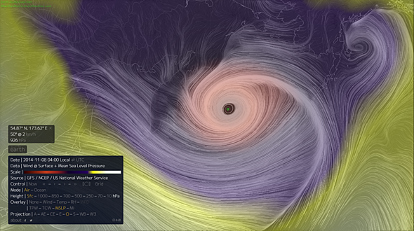 [Depiction of the forecasted wind field associated with this superstorm near Alaska; courtesy earth.nullschool.net]
Discussion
One of the most intense storms ever is about to move over the Bering Sea and it will have an impact on our weather in the eastern US in coming days. The Bering Sea is one of the stormiest parts of our planet, but it has rarely seen a storm like this and there is a chance that it could feature atmospheric pressure not seen this low in many decades in this part of the world.
Computer forecast models have been signaling for days that the remains of Typhoon Nuri will undergo a transition over the next few days into an extratropical storm as it moves away from Japan. As it does, unusually strong upper-levels winds across the North Pacific will help to intensify the system in a dramatic fashion – perhaps from around 970 millibars today to 925 millibars by tomorrow night. In fact, if it bottoms out at 925 millibars tomorrow night then it would tie the record for the lowest pressure ever recorded in the Bering Sea. The current record holder is 925 millibars and was set in October 1977 (in Dutch Harbor, Alaska). Note- as a point of reference, the lowest pressure recorded with Hurricane Sandy was 940 millibars. The storm will bring howling winds of up to 80 mph or so to the Aleutian Island chain and to the western part of the Alaskan mainland. Seas are forecast to build to at least 50 feet in the southwest Aleutians and perhaps even higher than that in the Bering Strait.
As far as possible ramifications on our weather…many times we’ve talked about “teleconnections” here at "VecnoreWeather.com" in which an event on one part of the world has an effect on another part of the world several days later. Indeed, this deep trough of low pressure developing in the Northern Pacific will likely translate downstream into a deep trough across the central and eastern US in coming days. In fact, it appears the reincarnation of Typhoon Nuri and some other atmospheric factors will lead to multiple rounds of Arctic air outbreaks into the Midwest and eastern US during the remainder of the month of November. One such major cold air outbreak is destined to reach the Mid-Atlantic region around Wednesday of next week.