
10:00 AM | An update on Tropical Storm Erika and the obstacles it faces
Paul Dorian

[Latest colorized IR satellite image of Tropical Storm Erika; courtesy University of Wisconsin/CIMSS]
Background
The US has not been hit by a major hurricane (i.e., category 3 or higher) since October of 2005 (Wilma) and, amazingly, Florida has not been struck by a hurricane of any intensity since the same time (and same storm). There is a chance that the hurricane drought in Florida ends by early next week, but it certainly is no guarantee and several factors can keep the drought alive for the state.
Overview
Tropical Storm Erika formed in the tropical Atlantic a couple of days ago and it appears to be headed on a track that will move it to the Bahama Islands by early in the weekend and then likely to a position off the east coast of Florida by Sunday or Monday. Steering currents in the upper part of the atmosphere to the south of a sub-tropical ridge of high pressure are likely to be flow out of the east or northeast during the next few days and this should push the system on a general west-to-northwest track. After that time, there are signs that the flow of air near the east coast will turn towards the north or northeast and this could actually push Erika away from the coastline – perhaps even before it ever makes landfall in the SE US.
Storm Intensity
As far as intensity is concerned, Erika has had trouble intensifying during the past 24 hours or so as its circulation centers have not been aligned properly for strengthening. Specifically, there has been a circulation center at lower levels of the atmosphere displaced from upper levels of the atmosphere and the best intensification usually occurs when there is one large vertically stacked central core to the storm.
During the next two or three days, Erika will have two - and perhaps three - factors that could cause it to weaken or, at a minimum, minimize its strengthening possibilities. First, there is an area of wind shear (changing wind direction in the atmosphere) that exists around the island of Hispaniola (yellow region below; current location of Erika indicated by white arrow). Wind shear contributed to the demise of Hurricane Danny just a few days ago in the same general area and it will likely present quite an obstacle for Erika over the next 48 hours or so. Second, there is some dry air in the expected path of Erika that it will encounter in the next 48 hours or so. This dry air originated over the Saharan Desert region of Africa several days ago and - similar to the wind shear – it could contribute to some weakening of Erika. Finally, Erika’s expected general west-to-northwest track will likely take the storm very close to Hispaniola and a slight shift in the track could bring it right over the island. This island has some rather high mountains and a move by Erika over the island could very well contribute to some significant weakening.
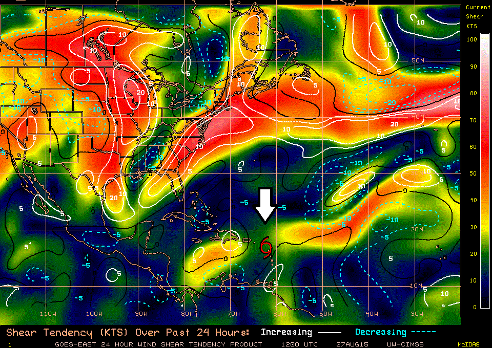
[24-hour atmospheric shear tendency; courtesy University of Wisconsin/CIMSS]
Longer Term
After these next few days when Erika encounters some wind shear and dry air - and perhaps even takes a path over the island of Hispaniola - overall environmental conditions should become more favorable for intensification for whatever remains of Erika. However, at this time the steering currents in the the atmosphere could possibly act to push Erika away from the coastline of the Southeast US. Stay tuned…there is hope that the hurricane drought in Florida continues. [Detailed video discussion on Erika below]:
Video
httpv://youtu.be/8Lc__pNR41A