7:00 AM | **Major coastal storm pounds away today at the NYC metro region...heavy rain/strong winds will combine to produce serious flooding concerns...colder air wraps around the system later tomorrow into Thursday**
Paul Dorian
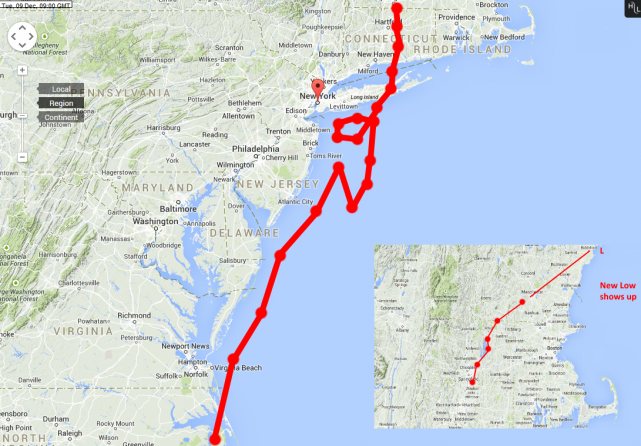 [Monday, 12Z European model storm track with the "loop"]
6-Day Forecast
Today
Cloudy, windy and cold with periods of rain, heavy at times, highs in the low-to-mid 40’s
Tonight
Cloudy, windy and cold with periods of rain, heavy at times, lows in the mid-to-upper 30’s
Wednesday
Cloudy, windy and cold with more rain, low 40’s
Wednesday Night
Cloudy and windy with rain mixing with or changing to snow showers, perhaps a heavier snow squall, cold, low-to-mid 30’s
Thursday
Mostly cloudy, windy, cold, snow showers possible, may be mixed with rain at times, perhaps a heavier snow squall, near 40 degrees
Friday
Partly sunny, breezy, cold, low 40’s
Saturday
Partly sunny, cold, low-to-mid 40’s
Sunday
Mostly sunny, chilly, mid-to-upper 40’s
Discussion
A major coastal storm will impact the region today as it slowly moves up the Mid-Atlantic coastline while intensifying. As it reaches the latitude of Long Island or southern New England this evening, it will run into an “atmospheric road block” forcing it to stall out or even loop around ensuring a long-duration event in the Northeast US and more precipitation around here from tonight into Thursday. The bulk of the precipitation today in the immediate NYC metro region should be in the form of plain rain, heavy at times, and amounts can exceed 2 inches by this evening. Coastal sections of New Jersey and Long Island could see wind gusts past 50 mph during the height of this major nor’easter later today and early tonight and flooding is an additional concern in those areas. The best chance for significant snowfall accumulations over the next 24 hours or so will extend from the mountains of upstate Pennsylvania and southern New York to interior New England where more than a foot can easily fall by Thursday.
Video
httpv://youtu.be/opPhkN9ixcw