7:00 AM | Big break coming in the overall pattern, but winter is not over yet
Paul Dorian
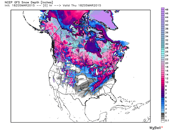
 [Pretty amazing to see 54% of the US with snow cover in early March (through mid-day Thursday); map courtesy Weather Bell Analytics]
6-Day Philly Forecast
Today
Brilliant sunshine today, but very cold, highs only reaching the low 20’s
Tonight
Partly cloudy, brutally cold, lows in the single digits
Saturday
Partly sunny, still quite cold, but not as harsh, mid 30’s
Saturday Night
Mostly cloudy, cold, low-to-mid 20’s
Sunday
Mostly sunny, moderate cold, near 40 degrees
Monday
Mostly sunny, a bit milder, low-to-mid 40’s
Tuesday
Partly sunny, chilly, mid 40’s
Wednesday
Mostly sunny, mild, near 50 degrees
Discussion
Very cold conditions will ease up this weekend and it’ll get noticeably milder as we progress through next week. However, despite this upcoming significant break in the overall weather pattern, winter is likely not through with us yet. Colder-than-normal weather is quite likely to return to the Northeast US later this month and last into April and there can even be more threats of snow.
A quick recap of this morning’s amazing cold and yesterday’s biggest snowfall of the year:
1) Record cold this morning for the date at Reading, PA, Allentown, PA, Wilmington, DE, Atlantic City, NJ, Dulles Airport, VA, Baltimore, MD 2) All-time record cold this morning for the month of March at Pittsburgh, PA, Harrisburg, PA 3) Snow totals yesterday at the 3 DC Airports (all daily snow records): DCA 4.8”, BWI 6.2”, IAD 9.4” 4) Philly region: 7.5” at PHL, 10.4” in King of Prussia 5) NYC region: Bronx 6.6”, Central Park 7.0”, JFK 5.8”