10:45 AM | *April pattern change is likely to bring more sustained warmth to the Mid-Atlantic, rains to California and the Southwest US, and a sharp increase in severe weather to the Plains/Midwest/Ohio Valley*
Paul Dorian
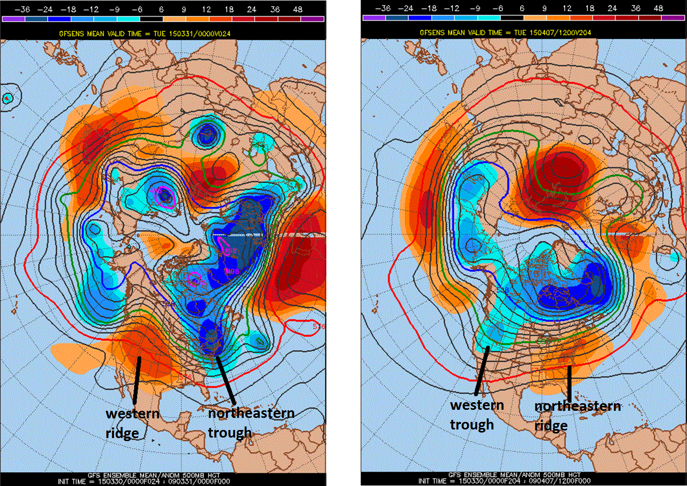
 [00Z GFS Ensemble run forecast maps of 500 millibar height anomalies for tomorrow (left) and April 7th (right); map courtesy Penn State e-Wall, NOAA]
Discussion
Overview The end of winter in the Mid-Atlantic region may be finally at hand. For several weeks now, the overall upper-level pattern has featured a ridge of high pressure along the west coast of North America and a trough of low pressure in the northeastern US. This pattern has brought about sustained colder-than-normal weather in the Mid-Atlantic region for the past few months, warmer and drier-than-normal weather for the western US, and it has helped to suppress severe weather activity in the Plains, Midwest and Ohio Valley. In fact, the tornado season is off to an historically low start as we approach the end of March (circled area on plot at bottom). All of this should begin to change over the next week or so as there will likely be a flip in the overall pattern with an upper-level trough forming in the western US and an upper-level ridge developing in the northeastern part of the country. Indeed, this upcoming upper-level pattern flip will have weather implications across the entire nation for much of the spring season.
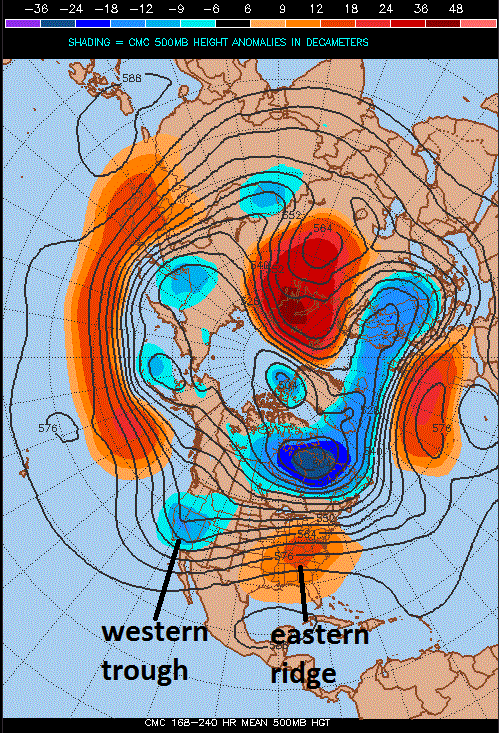
Mid-Atlantic warm up The latest GFS Ensemble computer forecast model run for the 500 millibar height anomalies (above) shows a reversal of positions for the ridge and trough in the US between tomorrow and a week later on April 7th. Other computer forecast models generally agree with this potential pattern flip including the European (not shown) and Canadian (below). This change in positions of upper-level features will have serious implications on the overall flow of air across the entire US with an increasing southwesterly flow pumping milder air in the Mid-Atlantic region. This southwesterly flow of air should result in above-normal temperatures on a more sustained basis than recent weeks in the Mid-Atlantic region beginning in the next week or so. January, February and March were colder-than-normal months in the Mid-Atlantic region, but April and May have good chances to be above-normal.
 [00Z Canadian model forecast map of 500 millibar height anomalies averaged out for the 7-10 day time period ending on April 7th; map courtesy Penn State e-Wall]
California drought The flip of upper-level systems from ridge-to-trough out in the western US is quite likely going to open the door for more rainfall in the Southwest US and this should include California which has been suffering through a long-term drought. The upcoming change in the overall weather pattern should allow for more eastward penetration of Pacific Ocean moisture into the western US and this should help alleviate the drought situation during much of the spring season. (San Francisco is suffering through its driest "January/February/March" time periods on record).
Threat for severe weather/tornadoes Finally, in addition to the warm up in the Mid-Atlantic region and the potential additional rainfall in the southwestern US, the increasing southwesterly flow of air in the eastern half of the nation will pump moist air northward from the Gulf of Mexico into the Plains, Midwest and Ohio Valley. This influx of moist air has been one important missing ingredient so far this spring in terms of the development of severe weather and tornadoes. Unfortunately, the addition of more humid and warmer air into the Plains, Midwest and Ohio Valley will likely result in a quick ramp up of severe weather and tornado activity that could take us from early-to-mid April into the month of May.
 [Tornado season is off to an historically low start through the first three months of the year; courtesy NOAA]