12:30 PM | *High-latitude blocking and an active southern branch of the jet stream spell trouble*
Paul Dorian
Overview
One of the key factors cited in the Vencore Weather Winter Outlook for a snowier-than-normal winter in the Mid-Atlantic region was the expectation for high-latitude blocking episodes this winter based on favorable signals from the Arctic Oscillation (AO) index, autumnal snowpack across Siberia, and on-going relatively quiet solar activity. In all likelihood, it appears we will have a stretch of at least two or three weeks with amazingly strong high-latitude blocking over places like Canada and Greenland which will increase chances for sustained cold air outbreaks into the Northeast US. A second important factor cited for more snow-than-normal this winter was the expectation that the strong El Nino phenomenon in the tropical Pacific Ocean would add moisture and energy to the southern branch of the jet stream. Indeed that appears ready to take place simultaneously with the high-latitude blocking as multiple storms are likely to trek from California to the Gulf of Mexico and then into the Northeast US during the next few weeks. All in all, it is looking very interesting and quite active for at least the next two or three weeks and significant accumulating snow is a good bet in the Mid-Atlantic region.

12Z GFS surface forecast map for late Tuesday night (blue=snow); map courtesy tropicaltidbits.com, NOAA
Near term
A mild soaking rain event is in the offing from late Saturday into early Sunday in the Mid-Atlantic region and then this system will be followed by much colder air for Sunday night and Monday. This initial blast of Arctic air for early next week is the same air mass that will bring about one of the coldest football playoff games ever on Sunday in Minneapolis - near zero for actual temperatures and much lower wind chills. (By the way, this will be the first outdoor playoff game played there since 1976 and next year they'll go back to a domed stadium).
A reinforcing Arctic blast will then arrive on Tuesday night and this frontal system looks quite active with lots of upper-level support. Snow showers and perhaps even snow squalls are likely to accompany this frontal passage Tuesday night into early Wednesday in the Mid-Atlantic region and it may even have an impact on the early Wednesday commute in some areas with small accumulations. The 12Z GFS forecast map (above) for late Tuesday night shows snow (blue) in the I-95 corridor as the secondary Arctic blast arrives.

Forecast map of 500 millibar height anomalies for Wed PM (Jan 13) from 00Z Canadian ensembles; map courtesy tropicaltidbits.com, NOAA
High-latitude blocking
If the current strong El Nino was the only player on the field this winter then much of the US would likely continue to experience warmer-than-normal weather during the remainder of the winter season. However, there is an atmospheric phenomenon that can counteract El Nino's warming during the winter season and known as high-latitude blocking. High-latitude blocking is generally characterized by persistent high pressure in northern latitude areas such as Greenland and northern Canada during the winter season. Without this type of pattern in the upper atmosphere, it would be quite difficult to get sustained cold air masses in the Mid-Atlantic region during the winter season; especially, during strong El Nino (warm) events.

AO and NAO indices past (black) and forecasts (red); courtesy NOAA
The AO/NAO signals
High-latitude blocking is tracked by meteorologists through indices known as the Arctic Oscillation (AO) and its closely-related cousin called the North Atlantic Oscillation (NAO). The Arctic Oscillation refers to opposing atmospheric pressure patterns in middle and high latitudes. When the AO is positive, for example, surface pressure is low in the polar region and this helps the mid-latitude jet stream to blow strongly and consistently from west-to-east keeping Arctic air locked up in the polar region. When the AO index is negative, there tends to be high pressure in the polar regions (i.e., high-latitude blocking), weaker zonal winds, and greater movement of polar air into the middle latitudes. The AO and NAO index plots above show past levels (black) and forecasted levels (red) for the foreseeable future - clearly in negative territory. In fact, the AO is headed to “off the chart” negative territory for some individual model runs. The 00Z Canadian ensemble forecast maps of 500 millibar height anomalies show the extreme anomalous high-pressure (orange, purple) across Greenland, Davis Strait and northeastern Canada and the active southern branch of the jet stream associated with deep upper-level low pressure (blues) during the middle of next week and also for the following weekend.
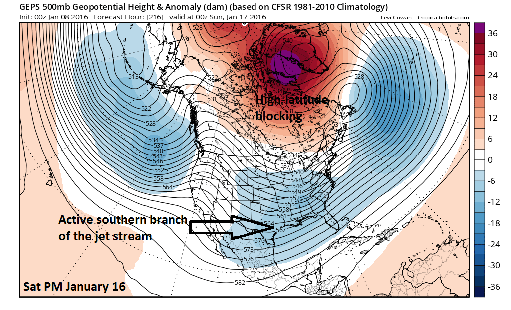
Forecast map of 500 millibar height anomalies for Sat PM (Jan 16) from 00Z Canadian ensembles; map courtesy tropicaltidbits.com, NOAA
Bottom line
Buckle up - the next two or three weeks look quite interesting.
Meteorologist Paul Dorian
Vencore, Inc.