12:25 PM | *Next week's winter storm signals the beginning of a prolonged cold period that could last into mid-March*
Paul Dorian
Overview
There is a break in the action for the next several days in terms of our recent active weather pattern and we’ll actually experience quite mild conditions by Saturday afternoon with a feeling of spring. This break, however, should not be interpreted as the “end of winter” as there are signs that a prolonged relatively cold and likely stormy weather pattern will set up in the eastern US from late February into as late as the middle of March. By no means does this mean each and every day will be below normal, but it does mean that when we look back on the period as a whole from late February to mid-March, it should be colder-than-normal for much of the eastern US. The beginning of this cold pattern will begin with a winter storm around the middle of next week which could bring a mixed bag of precipitation to the I-95 corridor including possible accumulating snow.
Short term
Temperatures are quite cold today following the passage of a cold front in the overnight hours and it’ll stay quite chilly on Friday as well. Milder air, however, will advance into the Mid-Atlantic region on Saturday and temperatures should climb well up into the 50’s and perhaps even touch the 60 degree mark in some locations. Colder air will make a return to the region early next week and then we’ll likely have to deal with another winter storm during the middle of next week.
12Z GFS forecast map for Wednesday morning (blue=snow, green=rain); map courtesy tropicaltidbits.com, NOAA
Winter storm threat
There are still many questions that remain for the winter storm that is likely to affect much of the eastern US next week in the "late Tuesday-to-early Thursday" time period. Odds currently favor a mixed bag of precipitation in the immediate I-95 corridor that may include some accumulating snow. The latest 12Z GFS forecast maps for next Wednesday morning (above) and Wednesday evening (below) show low pressure tracking off the Mid-Atlantic coastline and the rain/snow line right near I-95 (blue=snow, green=rain).
12Z GFS forecast map for Wednesday night; map courtesy tropicaltidbits.com, NOAA
Longer term signals for cold
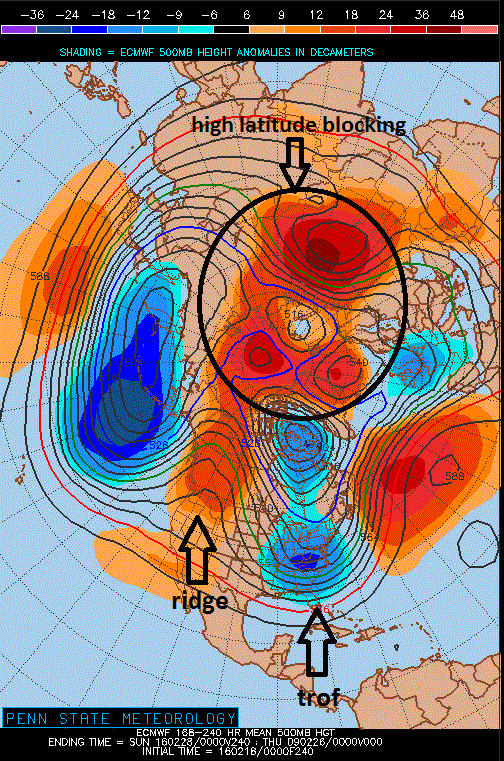
This next winter storm is actually going to come at the beginning of what looks to be a colder period of weather that could last from late February into mid-March in the eastern US. The 00Z European height anomaly forecast map at 500 millibars and averaged over the period of 7-to-10 days has some interesting features that point to a generally cold weather pattern in the eastern US. First, there is an eastern trough of low pressure (as indicated by the blues) averaged over this time period in one week to ten days. Second, there is extensive high pressure ridging (oranges) across the northwestern US and western Canada and this combination generally allows for the penetration of cold air masses from Canada into the northern US which eventually spill over into the Mid-Atlantic region. In addition, this forecast map suggests “high-latitude blocking” will form over the top (circled orange region) and this type of atmospheric pattern generally allows for cold air to become sustained in the Northeast US.
00Z Euro mean 500 millibar height anomaly map for the 7-to-10 day time period; map courtesy Penn State eWall
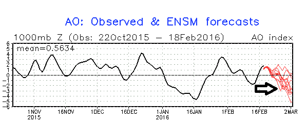
“High-latitude blocking” can be tracked by meteorologists through an index value called the Arctic Oscillation (AO). The Arctic Oscillation refers to opposing atmospheric pressure patterns in middle and high latitudes. When the AO is positive, for example, surface pressure is low in the polar region and this helps the mid-latitude jet stream to blow strongly and consistently from west-to-east keeping Arctic air locked up in the polar region. When the AO index is negative, there tends to be high pressure in the polar regions (i.e., “high-latitude blocking”), weaker zonal winds, and greater movement of polar air into the middle latitudes. The AO index plot shows past levels (black) and forecasted levels (red) into early March and the clear tendency is for a drop into negative territory which supports the idea depicted by the European 500 mb height anomaly forecast map described earlier.
Arctic Oscillation index (black=past, current; red=forecast)
Bottom line – sorry to say, it appears Phil the groundhog may have had it wrong this year.
Meteorologist Paul Dorian
Vencore, Inc.


