
2:40 PM | *Hurricane season “officially” begins next week and western Atlantic Ocean could become active*
Paul Dorian
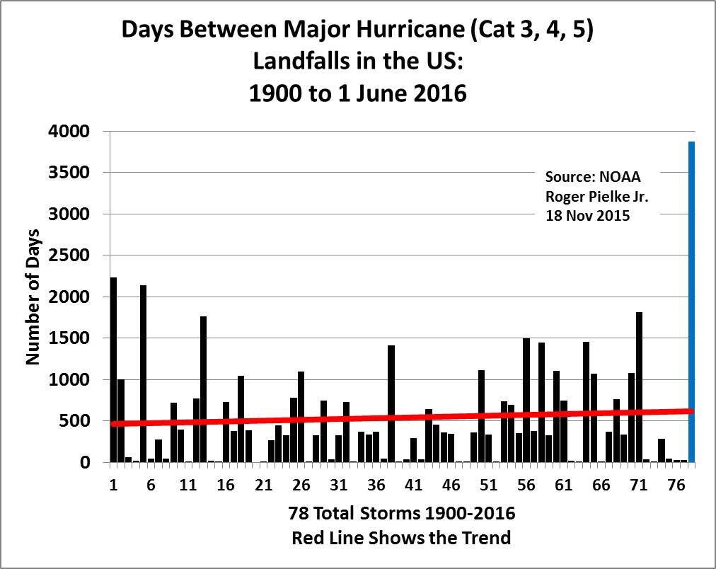
Current streak with no "major" hurricane strikes in the US is by far the longest since 1900 (blue bar at far right represents number of days); map courtesy Roger Pielke, Jr. (University of Colorado), NOAA
Overview
The “official” Atlantic Basin hurricane season begins on June 1st and it is likely to feature more activity than normal and more activity than seen in recent years which have been relatively quiet. The major factors involved with the "2016 Tropical and Mid-Atlantic Summertime Outlook" include a quickly weakening El Nino in the equatorial Pacific Ocean, the likelihood for the onset of La Nina by later in the summer, and the current sea surface temperature pattern across the tropical Atlantic Ocean. In a typical Atlantic Basin tropical season, there are about 12 named storms with 6 or 7 reaching hurricane status and only 2 or 3 actually reaching "major" status (i.e., category 3, 4 or 5). Amazingly, the US has not been struck by a major hurricane since 2005 – the longest such streak by far since 1900 – and this season will most likely present at least a few challenges for that streak to continue.

00Z Euro model forecast for Monday night with low pressure just off the Southeast US coastline; map courtesy tropicaltidbits.com
Possibility of “Bonnie” as early as next week
The 2016 tropical season actually began quite early this year with the formation of Hurricane Alex in January. In fact, Hurricane Alex was the first Atlantic hurricane in January since Alice in 1955 (Alice formed in December 1954 and continued into January 1955), and the first to form in the month since 1938. Alex did not have a direct impact on the US and spent most of its life over the Atlantic Ocean.

12Z GFS Ensemble forecast map of average 500 millibar height anomalies for 5-day period from Saturday to Thursday. High pressure ridging over southeastern Canada and Northeast US (orange) typically produce favorable conditions for tropical storm activity in the circled region; map courtesy tropicaltidbits.com, NOAA
There are signs that a tropical system could form in the western Atlantic Ocean early next week and if a system were to be named, it would be “Bonnie”. There are two factors that favor the formation of a tropical system in the period from late this weekend into the middle of next week. First, there will be an extensive upper-level ridge of high pressure across southeastern Canada and the Northeast US during the 5-day period from Saturday to Thursday. This type of pattern often allows for the development of a tropical system near the Bahamas, Southeast US or Caribbean Sea. Indeed, the forecast map of 500 mb height anomalies from last night’s GFS Ensemble run hints at a trough of low pressure in that "favored" zone. A second favorable factor for tropical storm formation in this region is the current sea surface temperature pattern which includes widespread warmer-than-normal waters across the tropical Atlantic Ocean, Caribbean Sea and Gulf of Mexico. The European model run from last night depicts an area of low pressure just off the Southeast US coastline next Monday night and this will be the area to monitor over the next several days for potential tropical storm formation.

Current sea surface temperature anomalies across tropical Atlantic Ocean, Caribbean Sea and Gulf of Mexico showing favorable warmer-than-normal conditions; map courtesy NOAA
Meteorologist Paul Dorian
Vencore, Inc.