3:30 PM | *The increasingly likely return of El Nino*
Paul Dorian
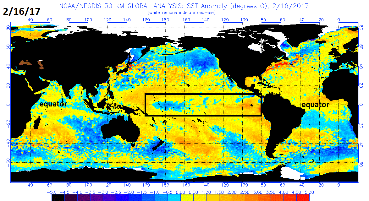
Sea surface temperatures anomalies as of 2/16/17. El Nino conditions (i.e., above normal SSTs) developing just off the west coast of South America (orange); courtesy NOAA
Overview
The past six weeks have seen the demise of weak La Nina conditions in the tropical Pacific Ocean and now there are signs of an unfolding El Nino. Ocean temperatures have increased to more than 2.0°C above normal just off the coast of Peru and this could very well develop into a more widespread event. Numerous computer forecast models now indicate a growing likelihood for an El Nino event in the equatorial Pacific – some as early as the spring in the Northern Hemisphere. If El Nino does form, it could have serious implications on global weather patterns and the 2017 Atlantic Basin tropical season.
Sea surface temperature anomalies just six weeks ago in early January with La Nina (i.e., colder-than-normal SSTs) conditions (blue) in much of the equatorial Pacific Ocean; courtesy NOAA
Sea surface temperature changes
La Nina is an oceanic phenomenon featuring below-normal sea surface temperatures in the tropical part of the Pacific Ocean and there was pretty widespread evidence of that early this year – albeit on the weak side. It was so weak, in fact, that many scientists were referring to this event as “La Nada” which translates as the “nothing” in Spanish. Sea surface temperature anomalies as of early January featured a widespread wavy pattern of cooler-than-normal sea surface temperatures along the equator, but that has changed quite a bit in just the past six weeks. Now there is only a small region of below-normal sea surface temperatures in the central part of the tropical Pacific and ocean temperatures are now clearly above-normal near the west coast of South America.
ENSO forecasts by a collection of dynamical and statistical models; courtesy International Research Institute for Climate and Society/Columbia University, NOAA
Numerical model forecasts
Numerous dynamical and statistical models are now forecasting an El Nino event later this year generally at weak-to-moderate levels. In fact, several of these models have an El Nino forming as soon as the spring season and this could have big consequences for the summer/fall tropical season in the Atlantic Basin. To achieve an official El Niño status, temperatures across a large part of the equatorial Pacific have to be at least 0.5 degrees above average and sustained for three months. The average of all of the dynamical models in the IRI/CPC plot is shown in yellow and it clearly heads into El Nino (positive) territory during the year.
Potential Consequences of El Nino
What goes on in the tropical Pacific Ocean can indeed have an impact all around the world. In 2015 and 2016, a powerful El Niño drove up global temperatures and played a role in droughts in many parts of the world. If El Nino gets fully underway during the spring season, it can actually have a “neutralizing” effect on the Atlantic Basin tropical season - which is, of course, a good thing. El Nino is an important predictor for hurricane activity because it generates stronger upper-level westerly winds that can tear storms apart in the tropical Atlantic Ocean and Caribbean Sea. In other words, El Nino years are often connected to weak hurricane seasons in the Atlantic Basin. A return of an El Nino event in the tropical Pacific Ocean this quickly would be somewhat unusual, but not unprecedented. Normally, the weather phenomenon only re-appears every two to seven years
Meteorologist Paul Dorian
Vencore, Inc.
vencoreweather.com


