10:25 AM | *Northern Hemisphere having a tough time shaking off winter*
Paul Dorian
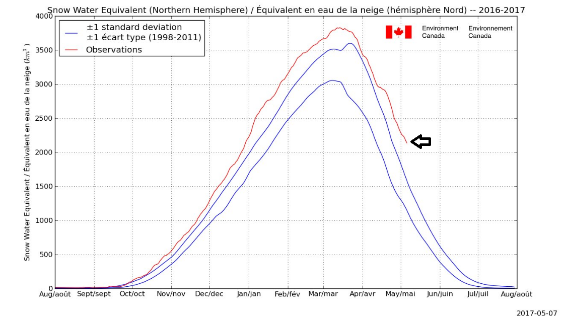
Snow is running at well above normal levels across the Northern Hemisphere; courtesy Environment Canada
Overview
Europe had an extended period of colder-than-normal weather in April accompanied by lots of snow and now much of the US is experiencing an extended period of colder-than-normal weather as we transition from early-to-mid May. Snowfall has been running at above normal levels this winter across the Northern Hemisphere and continues at those higher-than-normal levels as we heads towards the middle of May. In addition, temperatures in the Arctic region - which have been generally running at above-normal levels in recent weeks - have actually dropped to below-normal in recent days and, if this trend continues, it should prevent any chance for sea ice extent to reach record lows up there this summer. One of the main factors contributing to this late season cold across much of the Northern Hemisphere is a blocking pattern in the upper part of the atmosphere centered over Greenland and Iceland and this tends to contribute to cold air outbreaks into the land mass areas on both sides of the Atlantic Ocean.
Temperatures in the Arctic region (>80 degrees N) have fallen to below-normal levels (circled area) in recent days following several weeks at generally above-normal levels; map courtesy Weather Bell Analytics/Dr. Ryan Maue
Discussion
During the month of April, Europe experienced a persistent colder-than-normal pattern and significant snow piled up in the Alps across the central part of the continent. The air was so cold, in fact, that many vineyards from England-to-Italy suffered serious losses as the battle with freezing conditions was relentless in many areas. In the US, a colder-than-normal pattern has kicked in for much of the nation and should continue into the middle of the month and there has been some accumulating snow in the western US and across portions of the Northern Plains and interior Northeast. In fact, the next ten days or so will see more in the way of accumulating snow in the western US and many ski resorts in that part of the country will have good conditions right into the month of June. The Sierra Nevada Mountains of eastern California, for example, will get more substantial snowfall over the next ten days or so to add to the massive totals that they received this winter.
500 millibar height anomaly pattern with strong blocking (in red) over Greenland and Iceland and deep upper-level lows over the Northeast and Southwest US; map courtesy AER/Dr. Judah Cohen
The upper-level pattern across the Northern Hemisphere is playing a big role in this late season cold. This time of year, it is not too unusual to see deep upper-level lows scattered across the northern and middle latitudes and a blocking pattern would allow for persistent cold in areas situated under an upper-level low. Indeed, blocking is now well established over Greenland/Iceland as indicated by the latest 500 millibar height anomalies (red region) and this type of pattern can force cold air southward from northern latitudes into land mass areas on both sides of the Atlantic Ocean.
Arctic Oscillation (top) and North Atlantic Oscillation (bottom) index values for the current time and past few months (in black) and forecasted values are shown in red through the month of May; data courtesy NOAA
Two indices that meteorologists can track in order to monitor the pressure patterns over the northern latitudes are the Arctic Oscillation (AO) and North Atlantic Oscillation (NAO). When these indices drop into negative territory for extended periods this time of year, the result is often an upper-level blocking pattern across the northern latitudes. In recent weeks, the AO and NAO have indeed been generally negative and strong blocking way up north has contributed to late season cold across much of the Northern Hemisphere. In fact, the NAO has dropped to near record low levels in just the past couple of days. There is reason for hope that later this month this blocking pattern will fall apart and the computer model forecasts of the AO and NAO indices (shown in red) do suggest a return to positive territory in the relatively near future.
Meteorologist Paul Dorian
Vencore, Inc.
vencoreweather.com


