
7:00 AM | Possible tornado overnight in Kent Island, Maryland...more comfortable air coming for Tuesday/Wednesday, but could be another late day or evening round of showers and storms
Paul Dorian
6-Day DC Forecast
Today
Clouds give way to some sun, quite warm, chance of late day showers and thunderstorms, highs near 90 degrees
Tonight
Evening showers and thunderstorms possible and some of the storms can be strong-to-severe; otherwise, partly cloudy, mild, lows in the lower 70’s
Tuesday
Mainly sunny, quite warm, mid-to-upper 80’s for afternoon highs
Tuesday Night
Partly cloudy, mild, upper 60’s for overnight lows
Wednesday
Mainly sunny, warm, near 85 degrees
Thursday
Mainly cloudy, quite warm, showers and thunderstorms possible late in the day or at night, upper 80’s
Friday
Mainly cloudy, quite warm, chance of showers and thunderstorms, upper 80’s
Saturday
Partly sunny, quite warm, mid 80’s
Discussion
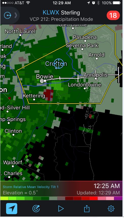
Some staggering rainfall amounts in the Mid-Atlantic region from late yesterday through the overnight hours with more than seven inches estimated by satellite in some spots. The hardest hit areas for rainfall included southern Chester County in southeastern Pennsylvania and northern Delaware where more than seven inches fell causing some serious flash flooding issues. Just to the east of DC, a possible tornado hit Kent Island, Maryland during the wee hours of the morning with damage now being investigated. A radar map of the thunderstorm cell showed rotation early this morning (red and green couplet) just to the south of Bowie and just before its arrival over Kent Island. Meanwhile, a cold front will work its way through the region today and there can be another round of late day or evening showers and thunderstorms and some of the storms can be strong-to-severe. High pressure will take control on Tuesday and the air mass will become noticeably more comfortable. Another front will bring back some unsettled weather here towards the end of the work week.
Meteorologist Paul Dorian
Vencore, Inc.
vencoreweather.com