
3:15 PM (Thursday) | **An active weather pattern setting up for the southern and central Plains in terms of severe weather and flooding rains...biggest threat comes on Monday/Monday night**
Paul Dorian

NOAA forecast map of total precipitation amounts over the next 7 days; courtesy NOAA/WPC
Overview
Unusually cold air has dominated the western states in recent days at the same time increasingly warm and humid air has ruled the southeastern states and this on-going split across the country will put the southern and central Plains right in the “battle zone” region in coming days. The combination of this sharp temperature (and humidity) gradient and vigorous upper-level energy will bring a couple of serious threats to the southern and central Plains for severe weather and flooding rains. The first opportunity for severe weather and heavy rainfall will likely come this Saturday and then an even more impressive threat will come on Monday and it may last into Tuesday.
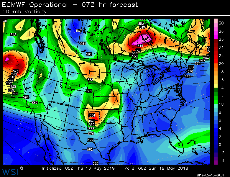
00Z Euro forecast map of 500 mb vorticity for Saturday evening; courtesy ECMWF, WSI., Inc.
Saturday threat
The same storm that has brought significant snow to the Sierra Nevada Mountains of eastern California will push across the interior western US over the next couple of days. By Saturday, the supporting wave of energy in the upper atmosphere will move across the southern and central Plains before it shifts on a more northeasterly track towards the Upper Mississippi Valley. At the surface, low pressure will develop over Oklahoma and Kansas and head off to the northeast towards Iowa late in the day. Very moist air will be in place ahead of the low pressure system and a dry line/cold front will advance across Texas during the day. Thunderstorms are likely to break out early in the day across Texas and Oklahoma and these storms will expand in coverage and intensity as the day progresses. Severe weather is certainly on the table for this event in the southern and central Plains from Texas to Iowa and this includes the threat for tornadoes with perhaps the greatest likelihood in Texas. In terms of rainfall, there can be up to a few inches this weekend and this will take place on grounds that are well saturated.

00Z Euro forecast map of 500 mb vorticity for next Tuesday afternoon; courtesy ECMWF, WSI., Inc.
Next week’s threat
By Monday of next week, the next in a series of troughs will intensify as it heads towards the central and southern Plains. From this vantage point, this particular wave of energy appears to be even stronger than the weekend system and it will trek to the east and into what will become a very moist and warm air mass. Low pressure is likely to spill out over the Rockies and into the central Plains early next week and this combination is likely to result in severe weather and flooding rains from Monday into Tuesday. Current model forecasts of wind profiles suggest supercells may form in the Texas/Oklahoma region on Monday and extremely heavy rainfall is possible as these storms are likely to be slow movers. This event could extend into Tuesday as the upper-level feature pushes off to the northeast in a somewhat similar path as the weekend system.
Stay on guard this weekend and early next week from Texas to Iowa.
Meteorologist Paul Dorian
Perspecta, Inc.
perspectaweather.com