
1:15 PM | *Alaska suffering through intense cold and there is no relief coming anytime soon*
Paul Dorian

The intense cold in Alaska has been well below-normal for this time of year and shows no signs of letting up anytime soon. This loop of 850 millibar temperature anomalies extends through a 12-day period from today, November 23rd to December 5th. Maps courtesy NOAA, tropicaltidbits.com
Overview
Temperatures have already peaked today in Fairbanks, Alaska and are currently right around the zero degree mark and they are very likely to stay below zero during the entire time for at least the next week or so. In fact, low temperatures this weekend are likely to be near 25 degrees below zero in the midst of an on-going intense cold spell that may last right into December and will no doubt result in additional broken records. While Alaska is normally quite cold this time of year, these temperatures are well below normal in many cases - quite a contrast from recent years - and some spots are likely to end up with their coldest November on record.

King Salmon, Alaska has suffered through 13 straight days with intense cold and temperatures ranging anywhere from 15 degrees to 31 degrees below normal (temperature departures from normal boxed in red). This month is very likely going to turn out to be the coldest November on record for this southern Alaskan town. Data courtesy NOAA/NWS.
Details
Some of the recent winter seasons in Alaska have been warmer-than-normal, but this year is getting off to a very different start with persistent intense cold in the 49th state. This is not your typical cold for the state of Alaska and many low temperature records could be broken in coming days…some spots are liable to end up with their coldest month of November ever recorded.

Sea surface temperatures to the south and west of Alaska are colder-than-normal this year (right plot) whereas one year ago (left plot) and in many recent years they were running at warmer-than-normal levels. Data courtesy Canadian Met Centre
In Fairbanks, temperatures are likely to stay below zero from later today through at least the next 7 days or so. The normal high temperature in Fairbanks this time of year is +8 degrees (F) and -10 degrees (F) is the normal low and this upcoming weekend could feature temperatures bottoming out at 25 degrees below zero. Another example of the relentless cold comes from King Salmon (Bristol Bay region of southern Alaska) where the average daily temperature has ranged from 15 degrees below normal to 31 degrees below normal for 13 straight days. In fact, it looks quite certain that this will finish up as the coldest November on record in King Salmon as relief is not expected anytime soon. Numerous Alaska towns have experienced record low temperatures this past week including Bethel, Cordova and Alyeska with two days in each location and Homer with three days of record low temperatures and more records are likely to fall later this month.

Sea ice has responded to the intense cold with its greatest advance this early in the season since 2012. Plot shows Chukchi autumn ice-over date since the late 1970’s (Data courtesy NSIDC)
Alaska’s biggest city, Anchorage, is not escaping the intense cold with current temperatures in the single digits and likely to peak Tuesday afternoon near the 10 degrees (F) mark. The normal high temperature in Anchorage on this date is 26 degrees (F) and the normal overnight low is +15 degrees (F). In fact, temperatures this weekend are likely to bottom out near 15 degrees below zero which is 30 degrees below the normal for this time of year.
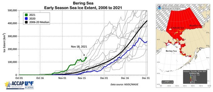
Bering Sea ice extent has reached levels not seen in many years for so early in the winter season. Plot shows Bering Sea ice extent since October 1st of 2021 (Data courtesy NSIDC)
One of the likely causes of the intense cold being experienced this month in Alaska is the colder-than-normal water sitting off the west and southern coastlines. This area of colder-than-normal water has been quite persistent in recent months and is quite a dramatic change from recent winters. Last year and in some of the prior winter seasons, the water was quite a bit warmer-than-normal in the northeastern part of the Pacific Ocean - likely playing a big role in some of the recent warmer-than-normal winters in Alaska.
With the persistent and intense cold and the colder-than-normal water temperatures, sea ice has responded accordingly and has grown quite rapidly - in some cases to its greatest extent this early in the season since 2012. For example, “ice-over” in the Chukchi Sea has already exceeded 95% of the basin which is the earliest on this date since 2012 and some four or five weeks earlier than the past 9 years. The Bering Sea ice extent is also off to its fastest start for this early in the winter season since 2012.
Meteorologist Paul Dorian