
10:15 AM | *A series of storms to impact the western states from later today through the weekend…snow measured by the foot for many higher elevation locations*
Paul Dorian

A series of storms will generate substantial snowfall over the next week in the higher elevations of the western US. Particularly hard hit will be the Sierra Mountains of eastern California where some spots could receive 100+ inches of snow as a series of storms pounds the region over the next 7 days or so. Map courtesy NOAA, tropicaltidbits.com
Overview
There is calm right now across much of the western US, but that will begin to change dramatically over the next 24 hours or so. A series of storms will impact much of the western states for an extended period of time beginning later today and continuing right through the upcoming weekend. These storms will bring significant rainfall to low-lying coastal sections from southwest Canada to California and substantial snowfall to higher elevation inland locations to be ultimately measured by the foot in many spots. In addition, severe cold will filter southward from western Canada this weekend into the Pacific Northwest and this could result in single digit cold for places like Seattle and Portland by early next week.

The pattern will turn colder and colder this weekend across the Pacific Northwest as bitter cold air from western Canada filters southward. This influx of very cold air will cause a lowering of the snow levels in Washington and Oregon and could result in single digit cold by early next week in places like Seattle and Portland. Map courtesy NOAA, tropicaltidbits.com
Details
Drought conditions continue to exist across much of the western US as we push towards the end of the year, but a powerful storm earlier this month help to improve circumstances somewhat and a series of storms over the next several days will provide even more improvement. This improvement will come at a cost, however, as many higher elevation locations in the western states are likely to be seriously impacted for travel in coming days by the expected accumulating snow and parts of the Pacific Northwest may have to suffer through some extreme cold.

In addition to the snow, rainfall will be significant as well in this next 7-day period for low-lying coastal sections of the western US and southwestern Canada. Map courtesy NOAA/WPC
California
In California, for example, the Sierra Nevada Mountain range is likely to see as much as 2-4 feet of snow by Thursday afternoon from this initial blast with the heaviest amounts to fall from tomorrow night into Thursday morning. Additional snowfall on the order of several feet can fall in this same area from Friday into the early part of next week as the onslaught of storms from the Pacific Ocean continues. The substantial snowfall expected over the next several days will pile on top of the several feet that fell in the same region earlier this month. Along low-lying coastal sections, rainfall amounts will also be significant with a few inches possible from northern part of the state all the way down to San Diego.
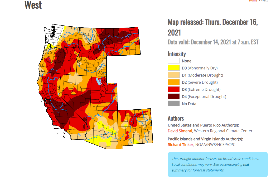
Drought conditions remain “severe, extreme and exceptional” in some parts of the western US and this onslaught of storms in coming days should to help alleviate this problem further.
Pacific Northwest
In the Pacific Northwest, significant snowfall is likely to fall in the higher elevations of the Cascade Mountains of southern Washington and northern Oregon. The snow will begin to pile up there later tonight and continue through the mid-week with more than a foot possible by early Thursday morning. As with California, a continuing onslaught of storms will bring more accumulating snow from Friday into the early part of next week and low-lying coastal sections could receive rainfall of at least a few inches. Over the weekend, colder and colder air will filter into the Pacific Northwest from western Canada so that by the time we get to Monday morning temperatures could be some 10-20 degrees below-normal. In fact, single digit cold is possible in places like Seattle and Portland by the early part of next week. One effect of the cold air intrusion into the Pacific Northwest will be to lower snow levels bringing accumulations to a wider area.
Meteorologist Paul Dorian
Arcfield Weather
Video discussion: