
7:15 AM | *“The Perfect Storm” - October 1991 - and the sinking of the Andrea Gail*
Paul Dorian

Visible satellite image from October 31st, 1991 (Courtesy NOAA)
Overview
Rapid changes in weather can be experienced in the northeastern US during the latter stages of October as to the west, cold Canadian air masses begin to regularly drop from Canada into the Northern Plains/Upper Midwest and to the east, the Atlantic Ocean remains relatively warm as it loses its stored summer heat more slowly than the continent. In fact, hurricanes can still form over the still relatively warm waters of the Atlantic Ocean and the contrast between the increasingly frequent cold air masses to the west and the warmth to the east often results in powerful storms just offshore. In late October 1991, several ingredients converged to create an immensely powerful storm that took on a few names including “The Halloween Nor’easter” or the “Unnamed Hurricane”. The most well-known name for this storm, however, is “The Perfect Storm” with a book and subsequent film of the same name.

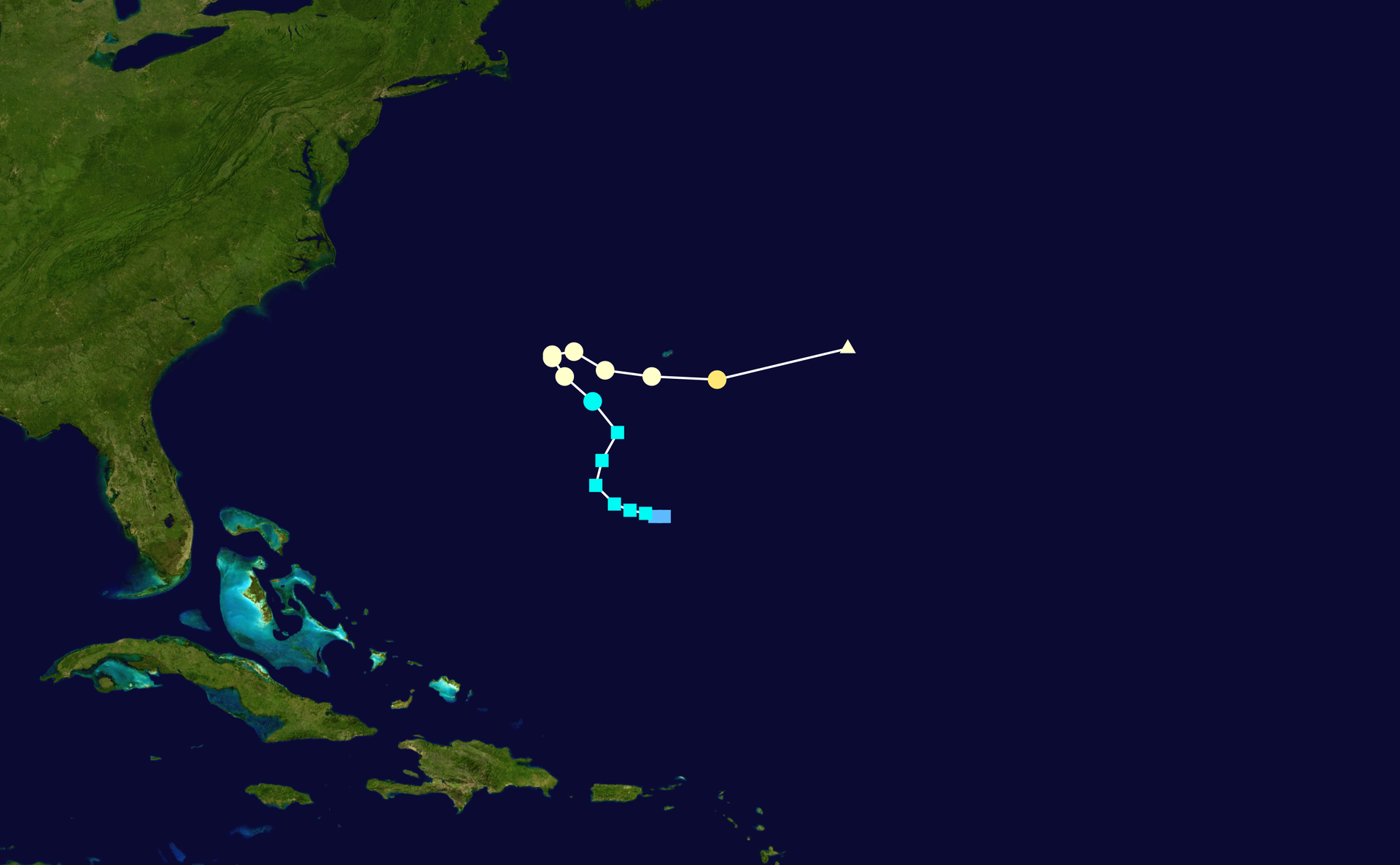
Visible satellite image from November 1st, 1991 (Courtesy NOAA)
Complicated sequence of weather events
“The Perfect Storm” began as an extratropical system then absorbed a tropical system (i.e., Hurricane Grace) and ended as an unnamed hurricane. The complicated sequence of events that led to the formation of “The Perfect Storm” involved a high-pressure system, a low pressure system, the remnants of Hurricane Grace, and an unusual retrograde motion (east-to-west) of the huge storm system. The evolution of “The Perfect Storm” began on October 26 with the formation of what became a short-lived hurricane named Grace. Initially, Grace had sub-tropical characteristics, but it was determined to be a tropical system on October 27th and peaked as a category 2 hurricane just to the south of Bermuda.

Surface map from October 28, 1991 at 7:00 PM ET (Courtesy: NOAA/Weather Prediction Center).
On October 28th, a cold front passed through New England and a strong ridge of high pressure built into eastern Canada. Low pressure formed just ahead of the cold front off the coast of Nova Scotia, Canada at the same time Hurricane Grace was positioned near Bermuda.
By October 29th, the low pressure system near Nova Scotia was intensifying and Hurricane Grace had moved to the northeast of Bermuda. Grace then started to become absorbed by the cold frontal boundary zone that earlier had passed through New England. By October 30th, the intensifying low pressure system was drifting to the southwest and reached its peak intensity of 972 millibars (28.70 inches). By this time, Hurricane Grace had been completely absorbed by the massive storm. On Halloween Day, October 31st, the storm started to weaken but its path to the southwest brought it over a warmer part of the Atlantic Ocean and it began to acquire sub-tropical characteristics.
Track of Hurricane Grace (October 26-October 29, 1991) (Credit: Wikipedia)
In fact, the storm system underwent a conversion from a “cold-core” to a “warm-core” system. Typically, in New England when hurricanes and tropical storms move into the area, they become sub-tropical or are considered “nor’easters”, but the opposite happened with this storm and this is where the “Unnamed Hurricane” phrase comes into play. On November 1st, a hurricane hunter aircraft found that the convection in the center of the storm had increased to the point where tropical characteristics could be identified. Indeed, the storm became a hurricane, but meteorologists at NOAA’s National Hurricane Center decided to not name it to avoid further confusion. Finally, by November 2nd, the storm began to speed off the northeast passing over the same area it originally formed just days before. It made landfall as a tropical storm on November 2nd in Nova Scotia which was about a week after the formation of Hurricane Grace.

Waves along the Massachusetts coastline during the Perfect Storm (Courtesy: Boston Globe).
Andrea Gail
While the storm was intensifying rapidly, a 72-foot Massachusetts-based commercial swordfishing boat named Andrea Gail was sunk with the loss of a six-man crew presumably in the hours after midnight on the 28th of October. The doomed vessel sent its last transmission at around 6 p.m. on October 28th about 162 miles east of Sable Island, a small slice of land in the northwest Atlantic Ocean about 185 miles south of Halifax. The captain, Billy Tyne, gave a final weather report to Linda Greenlaw, captain of a fellow swordfishing boat, the Hannah Boden, noting that he and his crew were experiencing winds of more than 90 miles per hour and 30-foot-tall waves. An all-out search for the crew and the Andrea Gail involving U.S. and Canadian militaries began on October 31st, after the ship's owner, Robert Brown, reported it overdue from the fishing expedition the day prior.

Robert Brown owned the Andrea Gail, with its home port at Marblehead, Massachusetts. The vessel was built and commissioned in 1978, with dimensions of 72 feet length, 20 feet beam, and 9.8 feet depth.
The search effort covered about 109,000 square miles and covered areas from the Grand Banks off Newfoundland, Canada where the ship had been fishing, to Cape Cod, Massachusetts according to the US Coast Guard report. The search effort was suspended late on the evening of November 9th due to the "low probability of crew survival." On November 6th, just days before the search was called off, a fishing net, a propane cylinder and an Emergency Position Indicating Radio Beacon were found by members of Canada's air rescue operations on the southwest corner of Sable Island. The items recovered by the air rescue crew were believed to belong to the Andrea Gail. Meanwhile, on November 8th, the Hannah Boden spotted a white full barrel with the initials A.G. on the side. But the barrels weren't retrieved, and a positive identification wasn't able to be made, according to the report. No distress calls were ever reported or received from the Andrea Gail. (Information Credit: Zachary Rosenthal, AccuWeather)
Among the items found from Andrea Gail are a 406Mhz Emergency Position Indicating Radio Beacon (EPIRB), a propane tank, fuel drums, an empty life raft, and some flotsam. The EPIRB was positively identified as belonging to Andrea Gail. However, it was never activated and was still in the off position. The Andrea Gail itself has yet to be found.
In the movie “The Perfect Storm”, the last scene was of a very large wave of nearly 100 feet that essentially sunk the boat and this depiction had credibility as a buoy in Atlantic Canada recorded a rogue wave of about that height. Waves as high as 25-feet occurred along coastal Massachusetts where winds were whipping up to about 80 mph. In Boston, 25-foot waves crashed onshore as high tides were running about 4 feet above average. The tide reached 14.1 feet above the average low tide which was about 1 foot lower than what was reported during the Blizzard of 1978. The story of the Andrea Gail was the subject of a 1997 novel called “The Perfect Storm” written by Sebastian Junger and the book turned into a movie with the same name in 2000. “The Perfect Storm” was a nickname given to the storm by Bob Case, a retired NOAA meteorologist who worked at Boston’s National Weather Service office.
Impact from the Caribbean to Canada
Dangerous surf was reported by this complex storm system all the way from the Caribbean to Canada. Many locations up and down the Atlantic coast saw tide, flood and storm surge records broken. In ocean City, Maryland, for example, a record high tide of 7.8 feet occurred beating the old record of 7.5 feet recorded during a March 1962 storm. Up the coast, hundreds of homes and businesses were knocked from their foundations by the powerful storm system with sea walls, boardwalks, bulkheads, and piers reduced to rubble in many areas. Numerous small boats were sunk at their berths, and thousands of lobster traps were destroyed. The Hudson, Hackensack, and Passaic rivers (NY, NJ) all experienced tidal flooding, and high winds brought down utility poles, power lines, tree limbs, and signs. The most extensive damage occurred in New England where federal disaster areas were declared for seven counties in Massachusetts, five in Maine, and one in New Hampshire. In Kennebunkport, Maine, the home of then President George H.W. Bush was damaged with blown out windows, flooding, and structural damage. There were a total of 12 lives lost by this storm system including the six-man crew of the Andrea Gail.
Meteorologist Paul Dorian
Arcfield
arcfieldweather.com