7:15 AM | *The deadly heat wave of July 1936 in the middle of one of the hottest summers on record across the nation*
Paul Dorian
Photograph of a dust storm captured in the Texas Panhandle during March 1936. When the drought and dust storms showed no signs of letting up, many people abandoned their land. The Dust Bowl exodus was the largest migration in American history. By 1940, 2.5 million people had moved out of the Plains states of which 200,000 moved to California. Courtesy PBS
Overview
July is well underway and no doubt, there has been some very hot weather in recent days; especially, across the southwestern states. Despite the hot weather so far this month, July 2023 will certainly have a difficult time matching the extreme and sustained heat of July 1936. In fact, one of the most widespread and destructive heat waves ever recorded in the US took place in the summer of 1936 which fell right in the middle of arguably the hottest and driest decade ever for the nation.
The decade of the 1930’s is renowned for the “Great Depression” and the “Dust Bowl”, both of which caused calamitous human suffering in this country. Not only were huge numbers of crops destroyed by the heat and lack of moisture in the “Dust Bowl” era, but thousands of lives were lost as a result of the heat, drought and economic hardship. This extreme heat wave was particularly deadly in high population areas where air conditioning was still in the early stages of development. The heat wave experienced in 1936 began in late June, reached a peak in July, and didn’t really come to an end until September. Many of the all-time high temperature records that were set in the 1930’s in numerous cities and states still stand today. Perhaps the hottest day ever recorded in the US took place on July 14th in 1936 when the average maximum temperature was 96°F and 70% of the US was over 90 degrees.
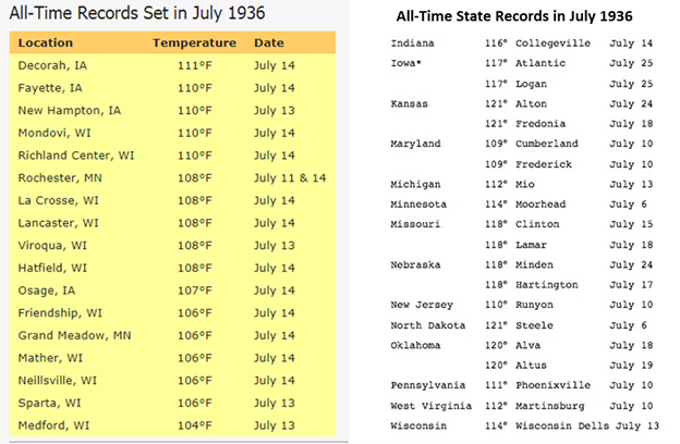
All-time city records (left, courtesy NOAA)
All-time state records (right, courtesy wunderground.com)
Note - the all-time high temperature record of 111°F in Pennsylvania was actually set on both July 9th and July 10th in Phoenixville (Chester County) during this heat wave.
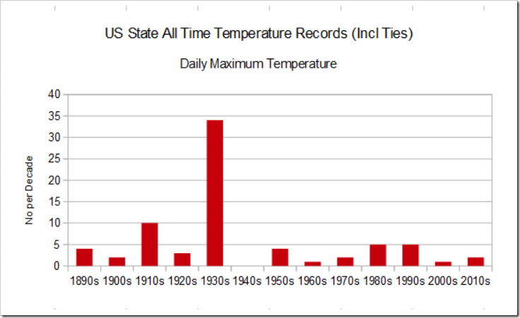
Distribution of state all-time high temperature records on a decade-by-decade basis with the highest number in the 1930’s. Source: NOAA/NCDC
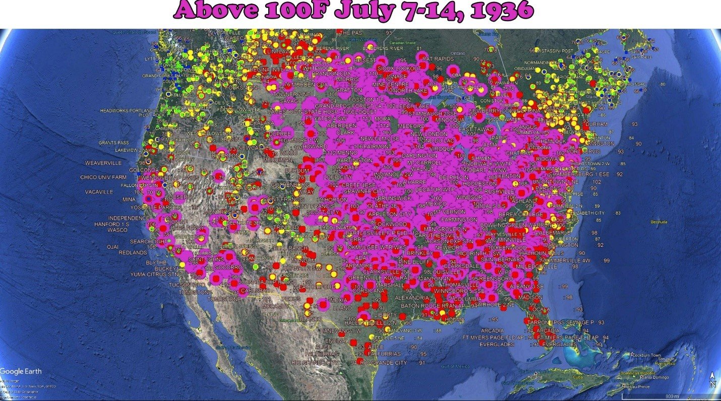
The week of July 7-14 in 1936 was especially harsh across the nation with numerous sites recording temperatures of > 100 degrees (purple circles). Credit Tony Heller, Twitter.
Discussion
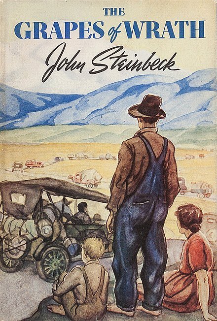
The “Dust Bowl” years of 1930-1936 brought some of the hottest summers ever to the US; especially, across the Plains, Upper Midwest and Great Lakes in arguably the hottest decade on record for the US (source 1, source 2). In addition, there were a series of droughts in this time period which ruined crops all across the Plains where, for example, lush wheat fields became unproductive waste lands. The suffering in the “Dust Bowl” era was brought to life at the end of the decade in the book written by John Steinbeck called The Grapes of Wrath which follows the migration of a poor family of farmers from drought-stricken “Dust Bowl” farmlands to the state of California.
The relentless drought across the central Plains during these “Dust Bowl” years contributed in a “positive feedback” fashion to the excessive heat by allowing the sun’s energy to be used almost exclusively in the heating of the ground and lower atmosphere without much energy loss at all in the evaporation of soil moisture. Several studies have linked the onset of the “Dust Bowl” to persistently cool waters in the tropical Pacific (or La Niña) in the 1930s (e.g., Schubert et al., 2004; Seager et al., 2005; and Cook et al., 2008).
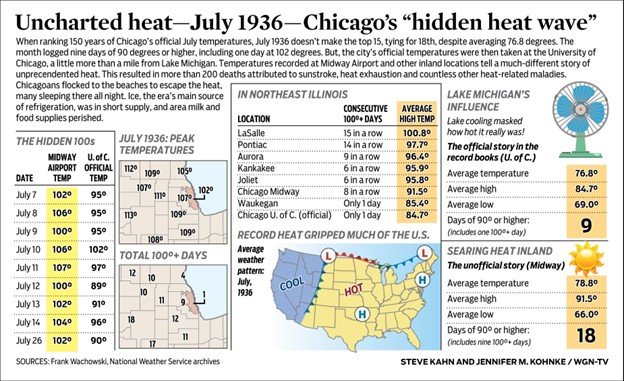
The Chicago metro region was hit particularly hard by the extreme heat in the summer of 1936, but the severity was masked by the official records kept at that time. The city’s official temperatures in 1936 were logged at the University of Chicago which was a little more than a mile from Lake Michigan. Temperatures at Midway Airport and other inland locations tell a much different story of the unprecedented heat than those reported at the official site. Credit Frank Wachowski, National Weather Service; Steve Kahn/Jennifer Kohnke, WGN-TV.
An amazing loss of life due to the widespread and destructive heat wave in July 1936 (Courtesy The Bend Bulletin newspaper (Oregon))
The worst of the extreme heat in the summer of 1936 took place during the middle part of July. In the week that ended on July 18th, thousands of lives were lost due to the extreme heat and relentless drought conditions across the nation. NOAA’s National Weather Service estimates that as many as 5,000 thousand lives were lost during the July 1936 heat wave. High temperatures of 100+ degrees (F) were widespread in this time period and numerous cities and states set their all-time high temperature records which still stand today (including in the Mid-Atlantic states of Pennsylvania, New Jersey and Maryland).
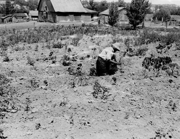
Mrs. W.E. Johnson works her shriveled potato patch on the family farm north of Columbia, Mo., in July 1936. Only one-fourth of normal rainfall fell that summer, ruining crops and pastures. The heat wave accompanied a drought that covered much of the Midwest and Plains until scattered rainfall finally broke through on Aug. 28. (St. Louis Post-Dispatch)
A few examples of the extreme heat that peaked in the Northern Plains and Upper Midwest on July 14th, 1936 included 112°F near Chicago, Illinois, 108°F in Minneapolis, Minnesota, and 110°F in Bismarck, North Dakota. In Minneapolis, the high temperature record set on July 14th still remains today as the highest ever recorded there and the heat caused 51 deaths in St. Paul alone on that particularly deadly day.
The front page of the July 13, 1936, issue of the St. Paul Daily News
The Mid-Atlantic region wasn’t spared in this widespread extreme heat wave with high temperatures on July 14th of 104°F in Philly and Washington, DC. In fact, the highest temperatures ever recorded in New York City (106°F) and Baltimore, Maryland (107°F) were set on July 10th, 1936. Even as far away as Toronto, Canada, temperatures reached 100°F and the reported death toll there for the heat wave was 225, the biggest spike in the city’s death rate since the 1918 flu pandemic.
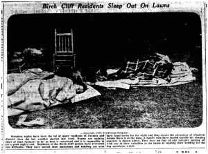
Image from the July 14, 1936 (Toronto) Evening Telegram showing “Birch Cliff” neighborhood residents sleeping outdoors.
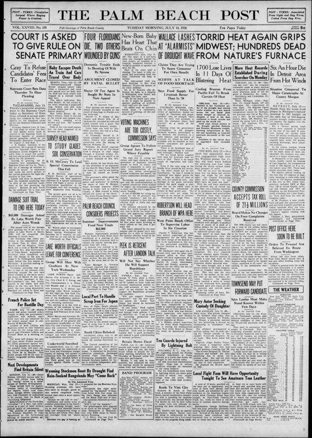
Another newspaper headline on the deadly heat wave in mid-July (July 14, 1936)
Even in the latter stages of July in 1936, there were some absolutely amazing temperature readings as the relentless extreme heat continued in many areas. For example, a minimum temperature of 91°F was reported at Lincoln, Nebraska on the night of July 24-25 and the daily high on the 25th reached 115°F – still an all-time high temperature record.
1936 clearly stands out on these two plots of July average (left) and mean (right) temperatures across the US going back to the 1890’s (raw, measured thermometer data).
It is worth noting that the “urban heat island” effect did not have the unnatural warming impact on overnight low temperatures that is experienced today in many locations. In August of 1936, the extreme heat shifted a bit southward and four southern states set their all-time high temperature records that still stand today (Arkansas: 120°F, Oklahoma: 120°F, Texas: 120°F, and Louisiana: 116°F). (Data Sources: Wikipedia; wunderground.com).
1936 – Year of extremes
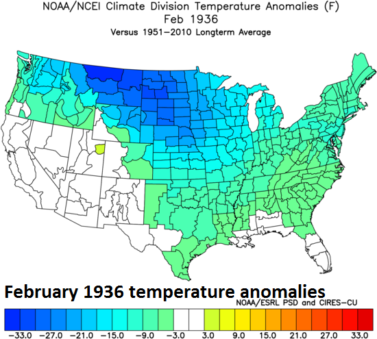
Interestingly, the exceptionally hot summer of 1936 actually followed one of the most severe cold waves in US history and some of the same regions that experienced the deadly summer heat suffered through the winter bitter cold (e.g., Northern Plains). The climatological summer (June-August) of 1936 was the warmest nationwide on record (since 1895) with an average temperature of 74.6°F (2nd warmest summer was that of 2006 with an average of 74.4°) and July of 1936 was the single warmest month ever measured with an average of 77.4°F (beating out July 2006 by 0.1°). Ironically, February of 1936 was the coldest such on record for the month with an average nationwide temperature of 26.0°F (single coldest month on record was January 1977 with a 23.6°F average).
In February of 1936 temperatures fell as low as -60°F in North Dakota, an all-time state record and Turtle Lake, North Dakota averaged -19.4°F for the entire month, the coldest average monthly temperature ever recorded in the US outside of Alaska. One town in North Dakota, Langdon, went for 41 consecutive days below zero (from January 11 to February 20), the longest stretch of below zero (including maximum temperatures) ever endured at any site in the lower 48. (Source: wunderground.com)
Meteorologist Paul Dorian
Arcfield
arcfieldweather.com
Follow us on Facebook, Twitter, YouTube


