
***Significant winter storm for the northern Mid-Atlantic region from this afternoon into Saturday***
Paul Dorian
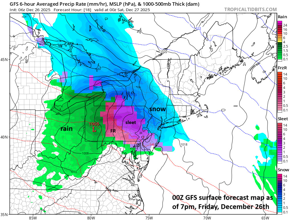
Precipitation gets underway during the afternoon hours in the Mid-Atlantic region with mainly snow across the northern areas and a mixed bag across the southern sections.
A fresh infusion of Arctic air from southeastern Canada in the overnight hours will set the stage for a significant winter storm in the Mid-Atlantic region from Friday afternoon into late Saturday. The cold air mass will be anchored by strong high pressure over SE Canada which will stay in place during the event. A thin layer of slightly above-freezing air in the upper atmosphere will nose into the southern Mid-Atlantic region creating conditions for sleet and freezing rain in many of those areas. The storm will bring substantial accumulating snow across the northern Mid-Atlantic region and a mixed bag of precipitation across the southern Mid-Atlantic. Travel conditions will deteriorate rapidly once the precipitation gets underway this afternoon and will remain very difficult right through tomorrow with temperatures at or below freezing in many areas through much of the event. Looking ahead, another Arctic outbreak reaches the Mid-Atlantic region on Monday night and a second shot around New Year’s Day.
Here is a breakdown for the Mid-Atlantic’s I-95 corridor:
NYC metro, central/northern NJ, east-central PA, NE PA: primarily a snow event with accumulations in the 5-9 inch range, isolated higher amounts, some sleet can mix in at times, surface temperatures stay below freezing through the event
Philly metro, northern DE, southern NJ: snow and sleet should dominate with some freezing rain, snow accumulations in the 1-3 inch range and there will likely be a thick layer of sleet, I don’t expect surface temperatures to get above freezing through most, if not all, of the event.
DC metro, northern MD, northern VA: mainly a combination of rain, freezing rain and sleet, a touch of snow is possible with little to no accumulation, watch for an ice buildup across the normally colder northern suburbs…temperatures will hove close to the freezing mark during much of the event.