*”Very strong” El Nino conditions appearing across the tropical Pacific Ocean...El Nino likely lasts into Spring 2027 with big implications on the winter season*
Paul Dorian
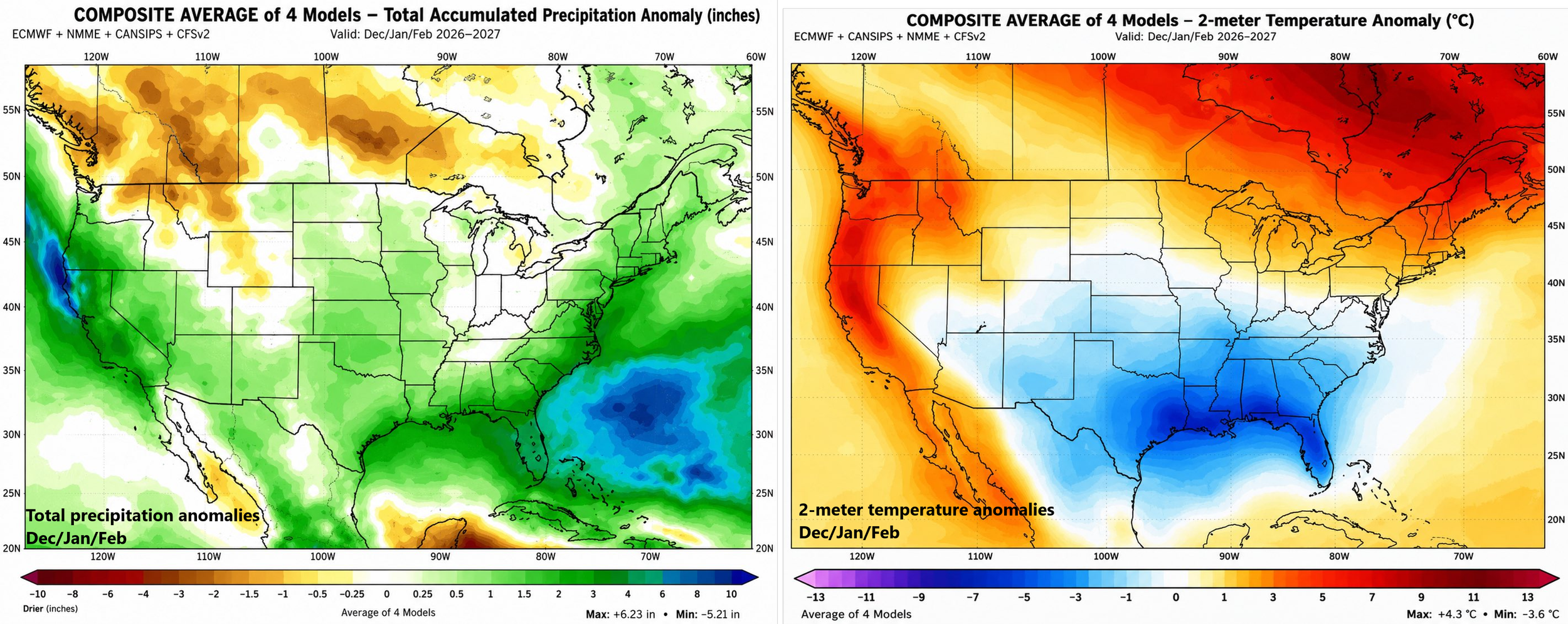
It is too early to confidently determine what kind of impact El Nino will have on the upcoming 2026-2027 winter season across the continental US, but there some consistent early signals coming from several long-range computer forecast models. These maps represent a compilation of four long-range models that average out to wetter-than-normal conditions across the west coast, southern and eastern US (left map)…colder-than-normal conditions in the Deep South, and warmer-than-normal across the west coast and much of the northern US (right map). Maps courtesy NOAA, ECMWF, Nathaniel Tabor, X
Overview
Water temperatures have climbed to well above normal levels in the tropical Pacific Ocean putting this on-going El Nino event into “very strong” category assuming these anomalies are maintained for a sustained period of time...virtually a certainty. In fact, this El Nino event will likely be ranked amongst the great events during the past fifty years or so including 1982-1983, 1997-1998, and 2015-2016 and indeed, there is a chance that when all is said and done, it may match with some of the greats going back to the 1800’s (e.g., 1877-1878). (By the way, and this is in the speculation phase on my part, I believe we may bounce back later next year to a strong La Nina considering we’ve been in a La Nina base state for the past several years with 5 of the last 6 winters featuring La Nina conditions).
Odds are quite high that El Nino conditions in the tropical Pacific will last into the winter season of 2026-2027 before it likely weakens next spring. As such, the upcoming winter can be greatly impacted by El Nino with the possible outcomes of numerous strong storms (due to the activation of the southern jet), markedly colder-than-normal temperatures across the southern US, and warmer-than-normal conditions in many of the northern states. There are many variables yet to be factored in; however, before we can have high confidence in any winter outlook and interactions between the Indian and Atlantic Oceans to the El Nino event in the Pacific are still unknown.
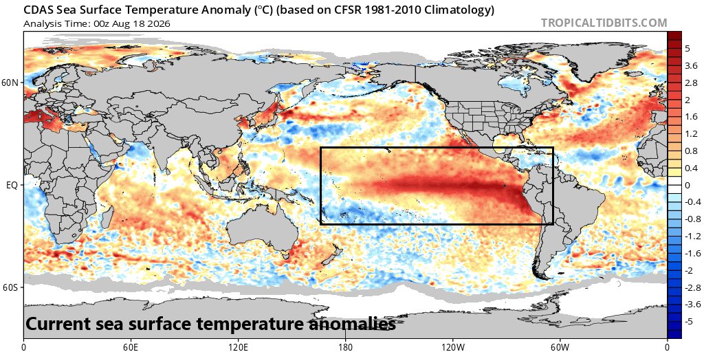
El Nino conditions continue across the equatorial part of the Pacific Ocean (boxed region) as we enter the final weeks of August and many model forecasts suggest they will last into the spring of 2027. Map courtesy NOAA, tropicaltidbits.com
Discussion
El Nino-Southern Oscillation (ENSO) is a natural climate cycle in the tropical Pacific Ocean that shifts irregularly every 2 to 7 years or so. It has three phases: El Nino (the warm phase), La Nina (the cold phase), and a neutral middle state. This system drastically alters global winds, ocean temperatures, and rainfall patterns and can certainly be an important player in the tropical season across the Atlantic Basin and during the winter season across the continental US.
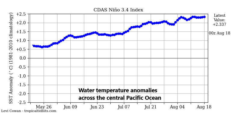
The central Pacific Ocean region known as “Nino 3.4” features water temperatures some 2.4 degrees C above the norm. Should these water temperature anomalies last for a sustained period 0 and odds are very high - this would meet the threshold of a “very strong” El Nino classification. Map courtesy NOAA, tropicaltidbits.com
El Nino (La Nina) events are classified as either being “weak,” “moderate,” “strong,” or “very strong” depending on how far above (below) average sea surface temperatures (SSTs) are in the central Pacific region known as “Nino 3.4” during the past three months. If the three-month averaged SST anomaly is +0.5–0.99°C (−0.5°C to −0.99°C), then the El Nino (La Nina) is considered “weak”. If it's +1–1.49°C (−1°C to −1.49°C), then the El Nino (La Nina) is “moderate”. If it's +1.5–1.99°C (−1.5°C to −1.99°C), then the El Nino (La Nina) is labeled as “strong”. If the sea surface temperature anomaly is ≥ +2.0°C (≤ −2.0°), then the El Nino (La Nina) is categorized as “very strong” and the latest actual observations show water temperatures in the central Pacific around +2.4°C relative to normal...easily in “very strong” territory if maintained for a sustained period of time. In fact, an average of numerous dynamical computer forecast models indicate sea surface temperature anomalies in region 3.4 (central Pacific) may approach +3.0°C by the forecasted peak of this El Nino episode in the October/November/December period.
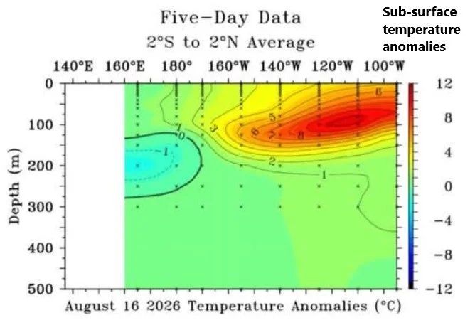
Deep-sea buoys continue to measure well above-normal water temperatures just beneath the surface in the eastern part of the tropical Pacific. Some of this very warm water has “bubbled” up to the surface resulting in “very strong” El Nino conditions. Notice also the cooler-than-normal water showing up now well beneath the surface near and to the west of the International Dateline…perhaps the first signs of a La Nina that could develop later in 2027. Map courtesy NOAA
If the magnitude of this El Nino event does indeed approach +3.0°C territory with respect to sea surface temperature anomalies, it would match or even surpass in magnitude the great events of 1982-1983, 1997-1998, and 2015-2016. In fact, these kind of water temperature anomalies could put it in the category of some very strong El Nino events going all the way back to the late 1800’s where, for example, paleoclimate reconstructions suggest there was just such an event during 1877-1878. Other exceptional El Nino episodes occurred in 1790–93, 1827–28, and 1844–45, but their exact strengths are uncertain (credit Chris Martz, X).
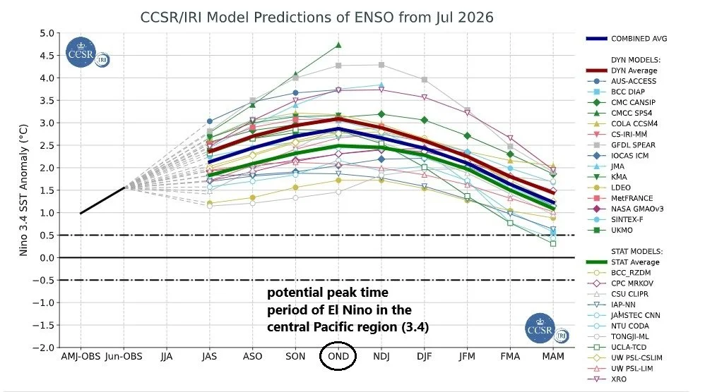
The graph show forecasts made by dynamical and statistical models for SST in the Nino 3.4 region for nine overlapping 3-month periods. Note that the expected skills of the models, based on historical performance, are not equal to one another. The skills also generally decrease as the lead time increases. Thirdly, forecasts made at some times of the year generally have higher skill than forecasts made at other times of the year--namely, they are better when made between June and December than when they are made between February and May. Differences among the forecasts of the models reflect both differences in model design, and actual uncertainty in the forecast of the possible future SST scenario. Courtesy CCSR/IRI
Impact on the Atlantic Basin tropical season and the upcoming winter
A very strong El Nino can certainly have a big impact on global temperature and precipitation patterns and some of the effects may very well be quite positive. For example, the tropical season in the Atlantic Basin is starting off rather quiet and it is likely to remain relatively quiet during the next few months thanks in large part to an El Nino-induced higher-than-normal level of vertical wind shear (i.e., change in wind speed and/or direction with increasing height), which is unfavorable for tropical cyclone formation and intensification.
Another positive benefit of a very strong El Nino event could be significant relief of drought conditions in portions of the western US (e.g., Colorado River Basin) during the upcoming fall and winter seasons. Typically, strong El Nino conditions will help to strengthen the sub-tropical (southern) jet stream during the late fall and winter seasons, and this should, in turn, result in numerous storm systems pushing across California into the southern US, and potentially, up along the Atlantic seaboard. Indeed, strong El Nino winters have certainly included blockbuster snowstorms up along the I-95 corridor region in the Mid-Atlantic/Northeast US such as during late January 2016 and early February 1983.
In terms of temperatures, a typical strong El Nino event would result in warmer-than-normal temperatures across the northern states – yet another potential positive benefit – but colder-than-normal conditions across the southern US. In addition, the southern states could be negatively impacted by a strong El Nino event with powerful Gulf storms during the winter (and spring) seasons that can enhance the chance of tornado outbreaks.
Plenty of time to better determine just how El Nino will impact the continental US during the late fall and winter-time periods...stay tuned.
Meteorologist Paul Dorian
Arcfield
arcfieldweather.com
Follow us on Facebook, Twitter, YouTube
Video discussion: