
2:45 PM | Pattern change continues to look likely in the eastern US by New Year’s Day, but two more record-breaking warm surges in the near term
Paul Dorian
Overview
The month of December has been much warmer-than-normal in the Mid-Atlantic region and there are at least two more widespread record-breaking days to come in the near future. Longer term, however, there are signals for an important pattern change in the eastern states as we begin the New Year. One of the signals for a pattern change is connected to a tropical disturbance called the Madden Julian Oscillation (MJO). Its projected changes over the next couple of weeks as depicted by a reliable computer forecast model (Euro) suggest changes are coming here by the beginning of January.

Lower atmosphere temperature anomalies for Thursday, December 24th; courtesy tropicaltidbits.com
Near term warm surges
The first of the record-breaking warm surges in the eastern US will take place tomorrow, Christmas Eve, with temperatures likely rising to the 70’s up and down the I-95 corridor (above). The second incredibly warm day will occur on Sunday, December 27th when records are also likely to fall in a widespread area of the eastern states. By Sunday, the nation will truly be “divided” with record-breaking warmth in the East and well below normal cold across the western states. The “dividing line” in the middle of the country will be ripe territory for the development of a major storm system which is likely to cause severe weather in its warm flank to the south and east of the low pressure center and a blizzard in its cold northwestern flank. In fact, up to two feet of snow is possible from this potential storm in the southern Plains come Monday or Tuesday of next week. As this storm moves northeast early next week, there is the chance for accumulating snow in parts of New York and New England by late Monday into Tuesday as cold air will push into that region from the Great Lakes and this snow threat could even extend as far south as Pennsylvania.
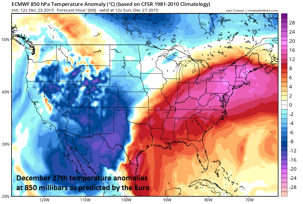
Lower atmosphere temperature anomalies for Sunday, December 27th; courtesy tropicaltidbits.com
MJO signals pattern change in the eastern US around New Year’s Day
The MJO is a tropical disturbance that propagates eastward around the global tropics with a cycle on the order of 30-60 days. It is a large-scale coupling between atmospheric circulation and tropical deep convection. The MJO has wide ranging impacts on the patterns of tropical and extratropical precipitation, atmospheric circulation, and surface temperature around the global tropics and subtropics. Furthermore, the MJO influences both precipitation and surface temperature patterns across the US. Specifically, one significant impact of the MJO in the U.S. during the northern hemisphere winter is an increase in the frequency and intensity of cold air outbreaks across the central and eastern US.

Euro model forecast of the MJO index between now and January 6th, 2016
Research has found that the location of the MJO, or phase, is linked with certain temperature and precipitation patterns around the world. The MJO phase diagram illustrates the recent and forecasted progression of the MJO index through different phases which generally coincide with locations along the equator around the globe. When the index is within the center circle, the MJO is considered weak, meaning it is difficult to discern. Outside of this circle, the index is stronger and will usually move in a counter-clockwise direction as the MJO moves from west to east. The very latest European computer model forecast of the MJO index propagates it from its current "phase 5" location into "phase 8" as we progress from December 23rd to January 6th (follow green line in figure above in a counter-clockwise fashion). Phase 8 (and phases 1, 2) for the MJO index this time of year (i.e., December/January/February) typically signals colder-than-normal temperatures in the eastern U.S. (see circled area below in "phase 8" temperature anomaly chart). The European model forecast of 850 millibar temperature anomalies for January 1st (below) shows quite a change in the overall temperature pattern from the near term warm surges to the beginning of the New Year.

Temperature composites for DJF based on the location of the MJO index

Lower atmosphere temperature anomalies for Friday, January 1st; courtesy tropicaltidbits.com
Stay tuned – we’ll continue to monitor this potential significant pattern change over the next several days.
Meteorologist Paul Dorian
Vencore, Inc.