
1:30 PM ***Major Hurricane Matthew likely to cause devastation to Haiti, eastern Cuba…US impact likely***
Paul Dorian
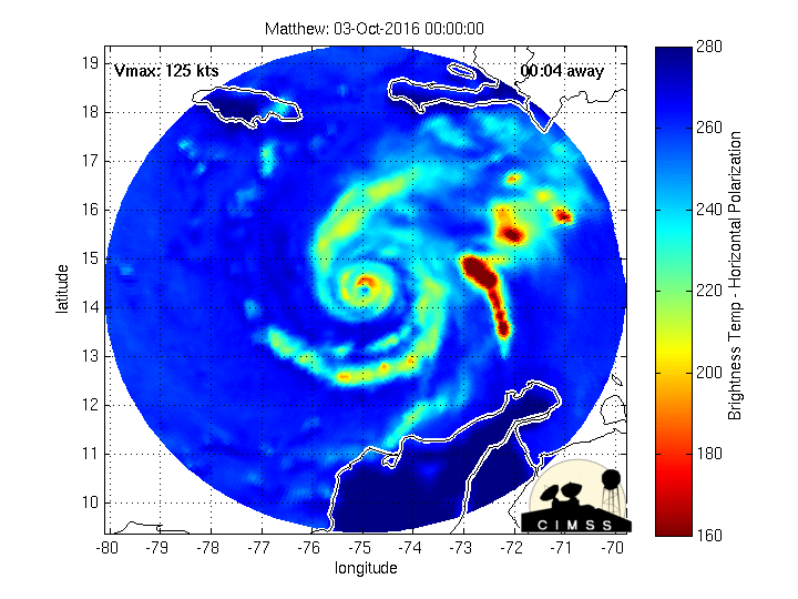
The eyewall of Hurricane Matthew is undergoing expansion and contraction as it grind to the north (land masses are fixed in this brightness temperature loop with Jamaica to the upper, left and Haiti to the upper, right); image loop courtesy University of Wisconsin/CIMSS
Overview
Matthew continues to churn through the central Caribbean as a major hurricane (category 4) with its latest measured max sustained winds at 140 mph and central pressure of 941 millibars (27.79 inches). It is grinding northward at 6 mph, and unfortunately, this slow movement will result in an extended period of high winds and heavy rain for many areas. In fact, there is the threat for as much as 40 inches of rain during the next couple of days in Haiti where this is an especially dangerous situation.
Dangerous situation for Haiti
The eye of Matthew has undergone some expansion and contraction during the past several hours as it slowly pushes northward (loop above). On this present course, Matthew is likely to strike eastern Cuba and Haiti during the next 24-48 hours and this expected storm track is an especially dangerous one for Haiti. A storm track like this for Matthew would put Haiti on the right side of the storm and this is likely to be where the rain and winds are most intense and storm surge is most severe. We talked earlier about similarities between this storm and Hurricane Hazel of October 1954 which took a similar track through the Caribbean Sea. Hurricane Hazel devastated Haiti and left anywhere from 500-1000 people killed - so keep them in your thoughts and prayers as well as all the other soon-to-be impacted areas.
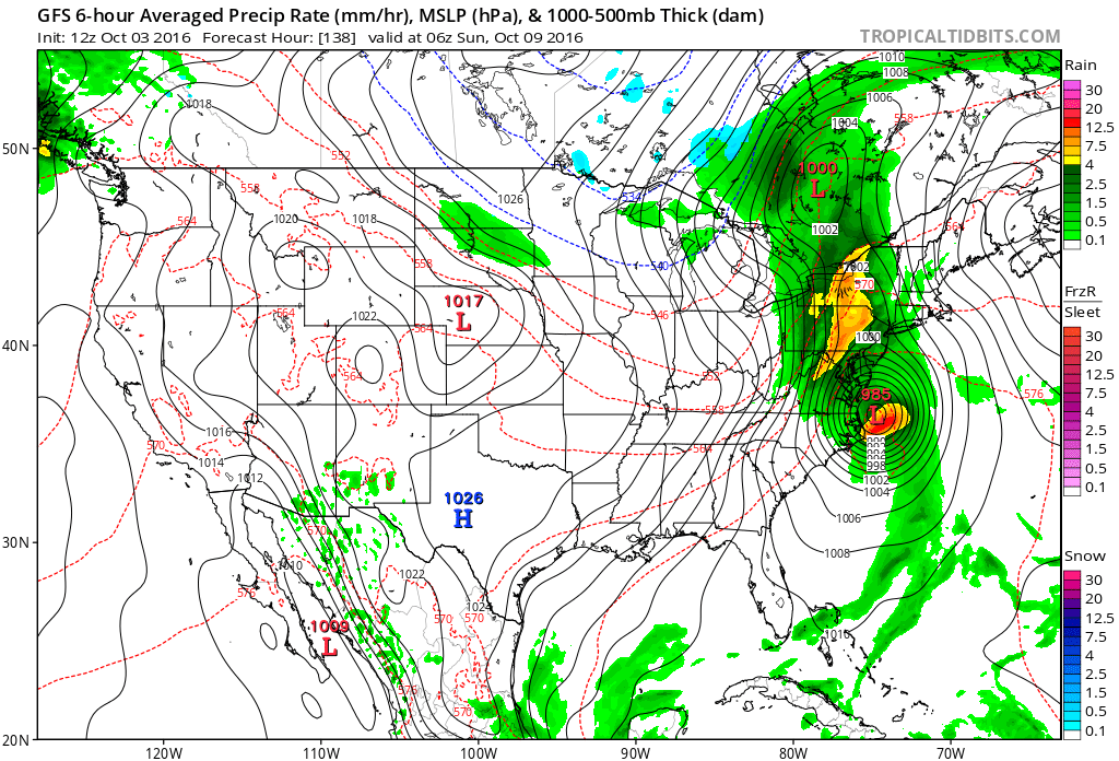
12Z GFS forecast map for Sunday morning; map courtesy tropicaltidbits.com, NOAA
Southeast US
Once Matthew passes north of the eastern tip of Cuba, it’ll likely slowly slog its way northwest through the Bahamas Island chain. While some weakening can occur as Matthew moves over the northern Caribbean Islands, it is likely to regain some strength over the Bahamas as it comes under the influence of a large upper-level ridge and moves over very warm waters of the western Atlantic. By the early part of the weekend, Matthew is likely to be near the South Carolina coastline and all coastal areas from Florida to North Carolina could be impacted. There is still an outside shot that Matthew comes even closer to the east coast of Florida than currently projected so all eyes there should continue to closely monitor this situation.

GOES-West water vapor imagery loop showing key player in Mid-Atlantic prospects for getting affected by Matthew (orange is where dry air is wrapping around an upper-level trough now centered over Utah, Wyoming); loop courtesy NOAA/GOES
Mid-Atlantic region
Looking beyond this time period to the weekend, the movement of Matthew becomes less certain. A key player as far as the I-95 corridor is concerned is an upper-level trough of low pressure now situated over the western US and seen clearly in the latest water vapor imagery loop (above). This trough will continue to move eastward over the next few days and ultimately it will interact with Matthew with two possible outcomes.

Surface map of Hurricane Hazel from October 15th, 1954...similar scenario could repeat this weekend with a N-to-S front edging into the eastern states and a hurricane near the Carolina coastline; map courtesy wikipedia
First, there is the chance that should this trough continue to progress steadily eastward over the next few days, it can effectively “push” Matthew to the northeast after its encounter with the Carolina coastline and inhibit it from having a big impact on the Mid-Atlantic region. However, it is also possible that the trough slows down a bit and interacts with Matthew as the hurricane slides relatively close off to the Mid-Atlantic coastline. A north-to-south frontal boundary could drop to the south of this upper-level trough this weekend and act as a conduit for Matthew’s rainfall right into the Mid-Atlantic. This second option – definitely on the table - would result in some heavy rainfall and strong winds later this weekend in the I-95 corridor from DC-to-Philly-to-NYC. Hurricane Hazel of October 1954 had a similar scenario with a frontal system extending north-to-south acting as a pathway for the hurricane moisture to ride up along the east coast. [Note-Hurricane Hazel made landfall whereas Matthew could stay just off the coast].

12Z GFS "ensemble" run forecast map for Saturday afternoon with a similar look to the operational GFS including heavy rain in the DC-to-Philly-to-NYC corridor; map courtesy tropicaltidbits.com, NOAA
Computer Models
As far as computer models are concerned, all models are in general agreement over the next five days or so in that Haiti and eastern Cuba get slammed by Matthew and then the hurricane slowly slogs northwest through the Bahamas and towards the Southeast US coastline. After that, divergence between the Euro and GFS computer models increases as the Euro tends to favor more of a northeast turn of Matthew after its encounter with the Carolina coastline and this diminishes the threat for significant rain and wind in the I-95 corridor. On the other hand, the 12Z GFS (and its ensemble run) bring the hurricane closer to the Mid-Atlantic coastline and this results in a bigger threat for significant rain and wind in DC, Philly and NYC.
Meteorologist Paul Dorian
Vencore, Inc.
Extended video discussion on Matthew: