12:50 PM | ***Major Hurricane Matthew crosses western tip of Haiti…Southeast US impact from Florida to North Carolina late this week/weekend…possible impact in I-95 corridor this weekend***
Paul Dorian
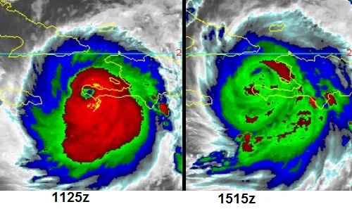
Colorized infrared satellite images a few hours apart from earlier today featuring brightness temperatures of cloud tops. The change in temperatures of the cloud tops suggests there was a slight weakening after Matthew's encounter with southwestern Haiti
Overview
The center of Hurricane Matthew has passed over the western tip of Haiti and is now back out over water on its way towards the eastern tip of Cuba. Its brief encounter with land has obscured the eye from its quite distinct appearance earlier this morning. Some further slight weakening can take place later today and tonight as Matthew briefly encounters the land mass of eastern Cuba, but the overall environment is quite favorable for it to maintain “major” hurricane status during the next couple of days.
Compilation of model forecasts of the track of Hurricane Matthew; map courtesy Weather Bell Analytics (Dr. Ryan Maue)
Southeast US impact
Matthew continues to be steered by the flow around the western edge of a subtropical high pressure system over the central Atlantic. This high pressure area will gradually expand westward and this broadening will likely cause Matthew to turn more to the northwest as it slogs its way through the Bahama Island chain. On this expected track, it is quite likely that a strong hurricane will come very close to the east-central coast of Florida in a couple of days.
12Z GFS forecast map for Saturday morning; map courtesy tropicaltidbits.com, NOAA
In fact, it is quite likely that the Southeast US coastline from Florida to North Carolina will suffer some impact by Matthew late this week and into the weekend. While the center of Matthew could stay off just off the coast of eastern Florida – still a close call – it may very well move a bit inland somewhere along the Carolina coastline early in the weekend. If Matthew actually makes landfall somewhere in the US as a major hurricane (i.e., category 3, 4 or 5), it would be the first since Wilma came ashore in southwestern Florida during October of 2005 as a category 3. This ongoing streak without a major hurricane strike on US soil is unprecedented in the record-keeping era that began way back in the middle 1800’s.
12Z GFS forecast map for Sunday morning; map courtesy tropicaltidbits.com, NOAA
I-95 threat
Looking ahead to the weekend, the movement of Matthew becomes a bit less certain, but it is likely to turn more sharply to the northeast once passed the latitude of around the Outer Banks of North Carolina. A sharp upper-level trough of low pressure now centered near Wyoming (see water vapor loop) and another one just off the Pacific Northwest coastline will move steadily eastward this week and ultimately interact with Matthew. Some rain and wind is possible in the I-95 corridor region from DC-to-Philly-to-NYC on Saturday even if Matthew stays off the Mid-Atlantic coastline which seems increasingly likely. The greatest chance for rain and wind from Matthew in the Mid-Atlantic region will occur at the coastline; however, a north-to-south frontal system will also be sliding into the eastern states assuring the chance for rain in inland areas as well at the coastline.
GOES water vapor imagery loop showing western US upper-level trough (near Wyoming) which will play a key role in the weekend weather along I-95; courtesy NOAA
Computer models
As far as computer models are concerned, all models are in general agreement over the next few days that Matthew will come quite close to the east-central coast of Florida and then pretty much parallel the coastline through Georgia and the Carolinas - and it could come ashore briefly somewhere in the Carolinas. After that, odds are increasing that Matthew will push away from the coastline to the northeast, but it still could have some impact here this weekend in the later Saturday-to-early Sunday time frame. The latest GFS model run has Matthew centered near the South Carolina coastline on Saturday morning and then off the Mid-Atlantic coastline by Sunday morning which is similar to recent Euro model runs.
Meteorologist Paul Dorian
Vencore, Inc.
Video discussion on Matthew:


