11:40 AM | ***Major Hurricane Matthew continues towards the east coast of Florida...now a category 4 storm and an outside chance at reaching category 5 status***
Paul Dorian
The eye is becoming more visible on recent visible satellite images as Matthew approaches Florida; image courtesy Penn State eWall, NOAA/GOES
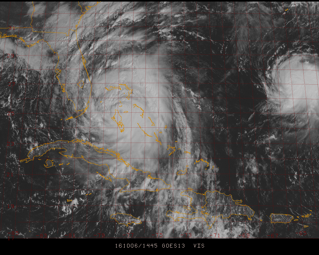
Hurricane Matthew continues churning northwest through the Bahamas and towards the east coast of Florida. It has now been upgraded to a dangerous category 4 classification and should arrive in the vicinity of Cape Canaveral, Florida early Friday morning with an outside chance at reaching category 5 status before its arrival. The eye has become noticeably more visible in recent satellite images indicating strengthening is on-going and as Matthew moves over very warm Gulf stream waters, the central pressure could continue to drop, and it is possible category 5 status may be attained by early tomorrow. If indeed Matthew makes landfall in Florida as a major hurricane, it would end an unprecedented streak in the US without a major hurricane since Wilma came ashore in southwestern Florida during late October of 2005. Since its last encounter with a major hurricane, the population in Florida has grown by the millions and lots of that growth has been near the coast.
A broader satellite view which shows the full extent of massive Hurricane Matthew and Tropical Storm Nicole is seen just to the east; image courtesy NASA, NOAA
After its arrival in east-central Florida, Hurricane Matthew looks like it will head right up along the coastline of northeast Florida, Georgia and then South Carolina during later Friday and Saturday. This type of track parallel to the coastline simply will extend the damage to a larger area and storm surge could reach as high as 8 or 9 feet in some areas - needless to say, get away from the coast. It is likely to weaken somewhat as it treks up along the Southeast US coastline due to increasing wind shear, slightly cooler sea surface temperatures, and its interaction with land. By the time it reaches as far north as around the northeast coastline of South Carolina, an eastward-moving strong trough of low pressure in the upper atmosphere over the middle of the country will have an increasing influence on its movement and Matthew should begin to turn eastward and then to the southeast – quite possibly with its center never making it into North Carolina.
The latest track from NOAA's National Hurricane Center; map courtesy NOAA
This sharp right turn looks like it will be the beginning of a loop to be made by Matthew which could actually bring it back into the vicinity of the Bahamas and eastern Florida by the middle of next week. This potential second visit, however, should see Matthew in a much weakened state partly as a result of cooler sea surface temperatures caused by expected upwelling from Matthew over the next couple of days during its initial encounter with that region. In addition to the eastward-moving upper-level trough, another player in the likely eventual loop of Matthew is Tropical Storm Nicole which is just to the east. Matthew and Nicole will tend to dance around each other for a few days and ultimately another tropical system, Otto, could form just to the south and head westward into the Caribbean Sea or Gulf of Mexico.
Model forecast of maximum wind speed gusts through Sunday in Florida; map courtesy Weather Bell Analytics
The latest official readings of Matthew are as follows: category 4 classification with max sustained winds at 140 mph. Its movement is to the northwest at 14 mph and the latest central pressure is 940 millibars – this pressure reading is well down from last night's recordings as the storm strengthened significantly in the overnight hours and that intensification has continued today.
Meteorologist Paul Dorian
Vencore, Inc.


