2:40 PM | **Significant rain here between late tonight and Wednesday night...impressive cold to reach North America**
Paul Dorian
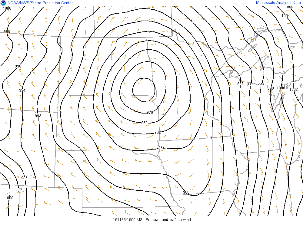
Powerful surface low pressure system now situated over the Northern Plains with a frontal system extending from its center to the eastern states; map courtesy NOAA
Rain
Two separate low pressure systems will bring significant rain and possible thunderstorms to the Mid-Atlantic region over the next 48 hours and also to much of the eastern 2/3rds of the nation where it has been quite dry in recent weeks. Atlanta, Georgia, for instance, has not had any measurable rain in 42 days - but that is all about to change. An eastward-moving frontal system that extends from a powerful storm over the North Plains will stall out in the eastern US over the next 12 hours or so and this frontal boundary zone will act as a conduit for copious amounts of moisture to ride along into the Mid-Atlantic region from the Deep South.
By the time early Thursday rolls around, many locations along the I-95 corridor from DC-to-Philly-to-NYC will have received 2 or more inches of rain from the two different low pressure systems. The first low will send rain our way late tonight and Tuesday and the second and likely stronger, wetter low will send more rain our way later Wednesday into Wednesday night. Temperatures will turn warmer during these two rain events and there can be some patchy fog around here as well as a thunderstorm or two. The front finally clears through the region later Thursday and high pressure with colder conditions will follow for the late week and weekend. Looking ahead, there can be another significant precipitation event during the early part of next week (Sunday/Monday) ahead of a cold blast that will ultimately affect much of the nation.
Minimum temperatures this weekend across Alaska with -67.9 degrees predicted; map courtesy Weather Bell Analytics (Dr. Ryan Maue)
Cold
Bitter cold air has dominated the fall season on the other side of the North Pole in places like Asia and Europe, but North America has had generally above normal conditions in the month of November including across much of Alaska. Barrow, for example, had its first subzero high of this cold season yesterday which ended a streak of 71 straight above average days and this was the first day where the high didn't make it to zero since April 3rd. This recent warmth in Alaska is about to change dramatically as temperatures this weekend could plunge to as low as 68 degrees below zero and much of the western US will experience a temperature plunge next week.
Temperature anomalies for the month of November across North America (left, warmer-than-normal) and Europe/Asia (right, colder-than-normal); map courtesy Weather Bell Analytics (Dr. Ryan Maue)
Our temperatures in the Mid-Atlantic region will go up and down this week with warmer weather on Tuesday and Wednesday to go along with significant rainfall and then it’ll turn colder at the end of the week. There might be another major rain event in the early part of next week in the eastern US and this could feature a warm up ahead and then widespread cold blast to follow for much of the country. The step down to colder will continue
in the Mid-Atlantic region through the first half of December.
Meteorologist Paul Dorian
Vencore, Inc.
vencoreweather.com


