
1:00 PM | **Widespread Arctic blast crosses the nation next week**
Paul Dorian
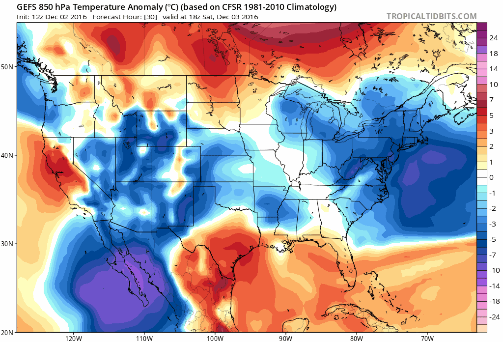
12Z GEFS forecast maps of 850 mb temperature anomalies between Saturday PM (12/3) and Friday PM (12/9); maps courtesy tropicaltidbits.com, NOAA
Overview
You probably want to get your Christmas lights up this weekend if you haven't done so already. The month of November ended on a warm (and wet) note in the Mid-Atlantic region and December is starting off slightly colder-than-normal, but big changes will take place by late next week. A widespread and very cold air mass is headed in Alaska this weekend where temperatures could plunge to 50 degrees below zero and then this very cold, dense Arctic air will dive into the western US early next week. After that, the Arctic air mass will spread to the south and east across much of the nation and reach the Mid-Atlantic region around Thursday and then we’ll likely be in a a struggle to pass the freezing mark on Friday.

12Z GFS forecast map of low temperatures on Monday morning (12/5) across Alaska with 51 degrees below zero predicted in circled area; map courtesy tropicaltidbits.com, NOAA
Details
The upcoming weekend will feature slightly below normal temperatures around here and dry conditions as high pressure builds eastward from the Ohio Valley. A weak system will spread some moisture our way by late Sunday night and Monday and, given the relatively cold weekend air mass in place, there can be some snow and/or sleet involved with rain late Sunday night into early Monday. A more important storm will pull out of the southern states on Tuesday and it is likely to bring a decent rainfall to the immediate I-95 corridor; however, snow and/or sleet could fall not too far to the N and W of the big cities. In addition, this system should soak the south-central and southeastern US which is good news for them considering the dry conditions of the past several weeks which are gradually being alleviated. By mid-week, the Arctic front will be blasting its way through the middle of the nation and then it arrives here later next week – perhaps preceded by a brief warmup and some rain.

Yesterday's Euro model output for low temperatures on Thursday, December 8. The nationwide average is 17.4 degrees (lower, left) which is very cold for this time of year; map courtesy Weather Bell Analytics (Dr. Ryan Maue)
The latest run of the GFS ensemble (GEFS) is quite impressive with its expansive push of the cold air to the Deep South (and even into Mexico) and this would quite likely result in some record lows for that part of the country. The nationwide average low temperature for Thursday morning according to the latest Euro model is 17.4 degrees (F) and that is very cold for this time of year. The GFS ensemble runs for temperature anomalies in the lower atmosphere (850 mb) suggests this air mass could be 15-25 degrees (F) below normal around here by the end of next week which would suggest highs might struggle to pass the freezing mark (normal high now in Philly is 50 degrees).
As far as snow is concerned in the upcoming ten days, the first necessary ingredient is to get cold air well-established in the Mid-Atlantic region and that is certainly looking like it’ll happen by the end of next week. Even though the late week Arctic blast will no doubt modify in subsequent days (it almost has to it'll be so cold), the overall colder-than-normal weather pattern should continue deeper into December once established. In the short term, there can be some snow (or sleet) around late Sunday night/Monday morning associated with a weak system, but this is somewhat limited in its moisture content. Tuesday’s rain event will have more available moisture for it to work with and it could result in snow (or sleet) at the onset not too far to the N and W of the big cities along I-95 - something to watch over the next few days. Later next week, as the Arctic front approaches, it could produce some rain showers around here and there is the chance that the rain showers change over to snow showers as the colder air pours in late Thursday into Friday. Looking farther ahead, the week that begins on Sunday the 11th will likely present one or more good opportunities for snow around here – after the cold air has become well established - perhaps as early as the Sunday the 11th or Monday the 12th.
Stay tuned, and get your Christmas lights up this weekend
Meteorologist Paul Dorian
Vencore, Inc.
vencoreweather.com