3:15 PM | Milder pattern setting up as we head towards the new year...but only a temporary break
Paul Dorian
12Z GEFS forecast map of 500 mb height anomalies for Sunday night; map courtesy tropicaltidbits.com, NOAA
Overview
There have been several significant Arctic air outbreaks during the past few weeks that have chilled the central and eastern US, but the overall upper-level pattern of recent days will undergo changes in the near term. The general result of these upper-atmosphere changes will be milder weather in the Mid-Atlantic region as we heads towards the new year. There are reasons to believe that this change; however, will just be a temporary break in the cold for us and a colder weather pattern will very likely return in a couple of weeks.
12Z GEFS forecast map of 850 mb temperature anomalies for Sunday night; map courtesy tropicaltidbits.com, NOAA
Upper-level changes
For much of the time in recent weeks, there has been upper-level low pressure across the northeastern US and southeastern Canada and Arctic air masses have persistently dropped southeastward from central Canada into the Mid-Atlantic region. This kind of pattern is about to change; however, and by Christmas Day, high pressure ridging will develop across the eastern US and upper-level low pressure will be confined to the western US. As a result of this change aloft, temperatures will climb to above-normal levels around here for awhile and the western US will have to suffer with the colder-than-normal conditions.
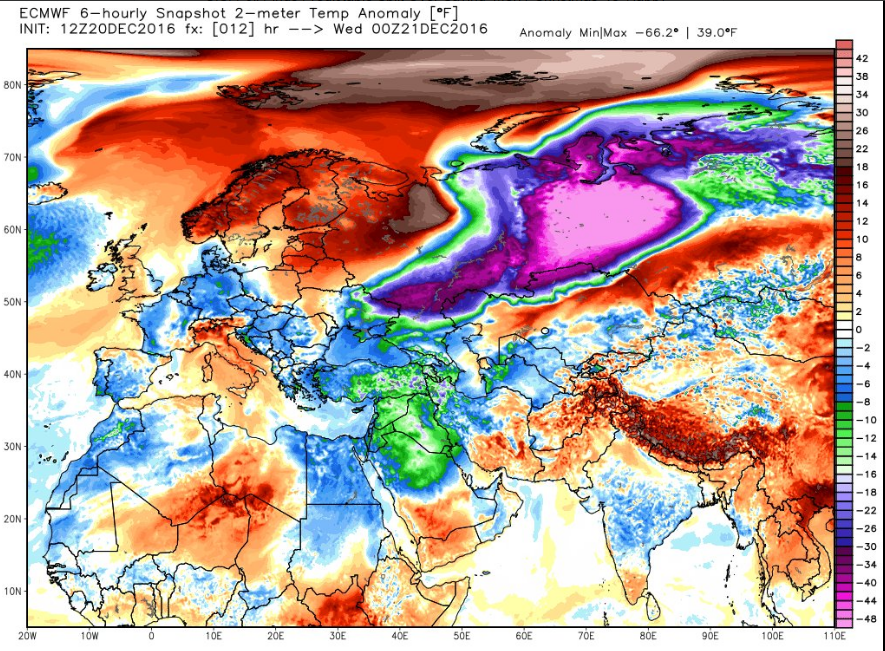
A big pool of significantly colder-than-normal air currently situated over central Russia (purple area); map courtesy Weather Bell Analytics (Dr. Ryan Maue)
Signs for future cold
This change to a milder weather pattern for the eastern US is very likely only a temporary one - perhaps up to ten days or so - and certainly not the end of winter. There is still very cold air situated across the other side of the north pole in areas like central Russia and it is way below-normal for this time of year. In addition, the snow cover across the northern hemisphere as a whole is way above-normal for this time of year and this bodes well for the formation of new cold, dense air masses that will likely eventually make their way into the eastern US. In fact, snow accumulation was just reported in the Saharan Desert (Algeria) region of Africa for the first time in 37 years.
Current snow cover across the Northern Hemisphere is quite high for late December
Christmas Day won't be like last year
While it will be relatively mild for Christmas Day (Sunday) compared to recent days, it won’t be nearly as warm as last year. Last year, Philadelphia reached 68 degrees during what turned out to be the warmest December ever recorded. In fact, temperatures hit 70 degrees on the 23rd and 24th last year, but it won't be anywhere close to that this upcoming weekend. High temperatures on Sunday, Christmas Day, could reach the 50 degree mark in the DC metro region and will likely reach the mid-to-upper 40's across Philly and New York City. Showers are likely to precede on Saturday, Christmas Eve - at least during the daytime hours - but they should move out of here by Saturday night.
Meteorologist Paul Dorian
Vencore, Inc.
vencoreweather.com


