12:00 PM | NOAA upgrades its primary computer forecast model
Paul Dorian
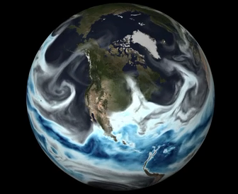
Precipitable water across North America on May 11th, 2016 as depicted by the GFS model (video link below); courtesy NOAA
Overview
The Global Forecast System (GFS) computer forecast model produced by NOAA is the foundation for all of its weather and climate models including those used for hurricane prediction and other high-impact types of weather. The operational version of this forecast model has just undergone a significant upgrade in the never-ending attempt to improve accuracy. This upgrade is the latest of several model improvements that are to be rolled out by NOAA in the next several months thanks to increased supercomputing power acquired earlier this year.
Details
The GFS model is run four times a day with each update forecasting out to 384 hours (16 days). The latest upgrade to the GFS builds on last year’s significant boost which more than doubled the resolution of the model grid from 27 kilometers to 13 kilometers. With the new version, the GFS model now delivers hourly forecast guidance out to five days instead of every three hours as before. This upgrade also prepares the GFS to make use of highly anticipated satellite observations from GOES-R which is scheduled to launch later this year. GOES-R is expected to provide images of weather patterns and severe storms as frequently as every 30 seconds. Satellite observations now provide around 99% of all observations that are fed into today’s computer forecast models as initialization data and this latest upgrade will allow for hundreds of thousands more earth observations to be utilized by the GFS.
Preliminary test results on the upgraded GFS model suggest there are improvements across the Great Plains in terms of identifying instability in the atmosphere that could lead to severe thunderstorms and tornadoes. Also, early tests suggest the upgrade may have improved precipitation forecasts for the continental US and the prediction of tropical storm development, track and intensity. It’ll take many months of usage by weather forecasters before the final results are in on the latest upgrade of NOAA’s GFS computer forecast model.
This video depicts moisture in the atmosphere over North America on May 11th, 2016 as depicted by the GFS model. This is the actual day the latest model upgrade became operational.
Meteorologist Paul Dorian
Vencore, Inc.

