3:30 PM | *Active tropics bear close monitoring over the next several days*
Paul Dorian
Three tropical systems in the Atlantic Ocean; image courtesy University of Wisconsin/CIMSS
Overview
The tropics are quite active now as we gradually move towards the climatological peak (mid September) of the Atlantic Basin hurricane season. There are three tropical systems in the Atlantic Ocean and one of these is likely to completely dissipate in the next few days, a second may impact the northern Caribbean Sea or the Southeast US/Bahamas region, and a third is likely to strengthen significantly as it treks towards the US. The front runner system is Tropical Depression Fiona and it is of least concern as it shows little sign of intensification. On its heels is another tropical system that is of some real concern as it is entering an area of very moist air and it will take a southern route towards very warm waters of the western Atlantic or Caribbean Sea. The third system is far out in the eastern Atlantic and it will take more of a northern route towards the US east coast and it should strengthen noticeably in the near future; however, it is unclear as to whether it will ever even make it close to the US coastline.
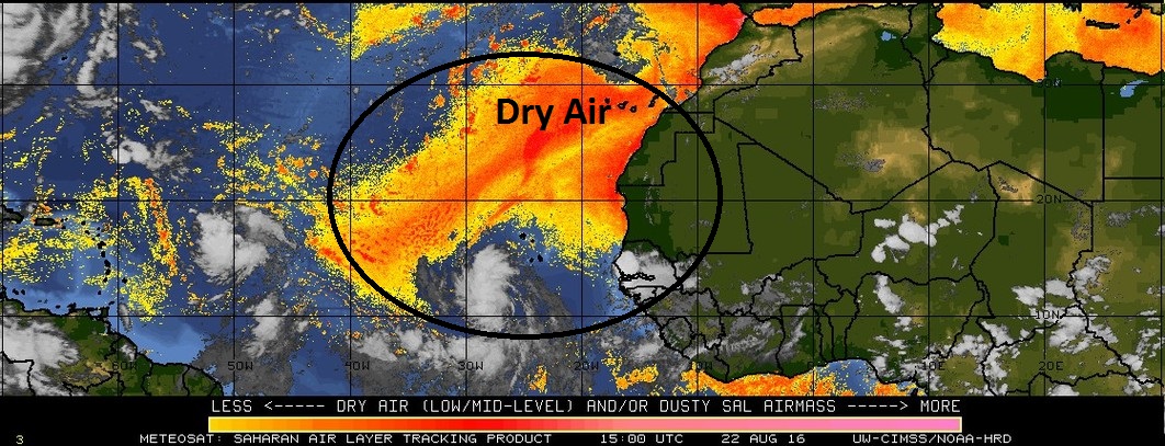
Dry Saharan Desert air over the eastern Atlantic Ocean; map courtesy University of Wisconsin/CIMSS
System 1 (99L)
The current Saharan air analysis map shows that the system known officially as 99L has already exited the dry air region (orange) and is in an area of increasing water vapor. This is a favorable factor for development and it is also headed for an area of above normal sea surface temperatures. As a result, there is potential for this system to intensify importantly by the time it reaches the northern Caribbean Sea or the Bahamas/Southeast US region later this weekend or early next week. In fact, it is not out of the question that a hurricane is sitting close to Florida by this time frame and then it could ultimately move across Florida and into the Gulf of Mexico (as depicted by the latest Euro forecast). Florida has not been hit by a hurricane of any intensity since 2005 (Wilma in October 2005).
12Z European model forecast for next Wednesday, August 31st; map courtesy tropicaltidbits.com
System 2 (90L)
This system is in the far eastern Atlantic and it is very likely to strengthen noticeably over the next several days. It will take a more northern route than 99L and is likely to head on a path towards the US east coast. However, it is too early to tell if this system will actually make it anywhere close to the coast or simply turn away harmlessly out-to-sea sometime next week.
Stay tuned.
Meteorologist Paul Dorian
Vencore, Inc.


