10:15 AM | *Florida unprecedented hurricane drought in jeopardy*
Paul Dorian
NOAA's high-resolution HWRF computer forecast map for late Saturday night; map courtesy tropicaltidbits.com, NOAA
Overview
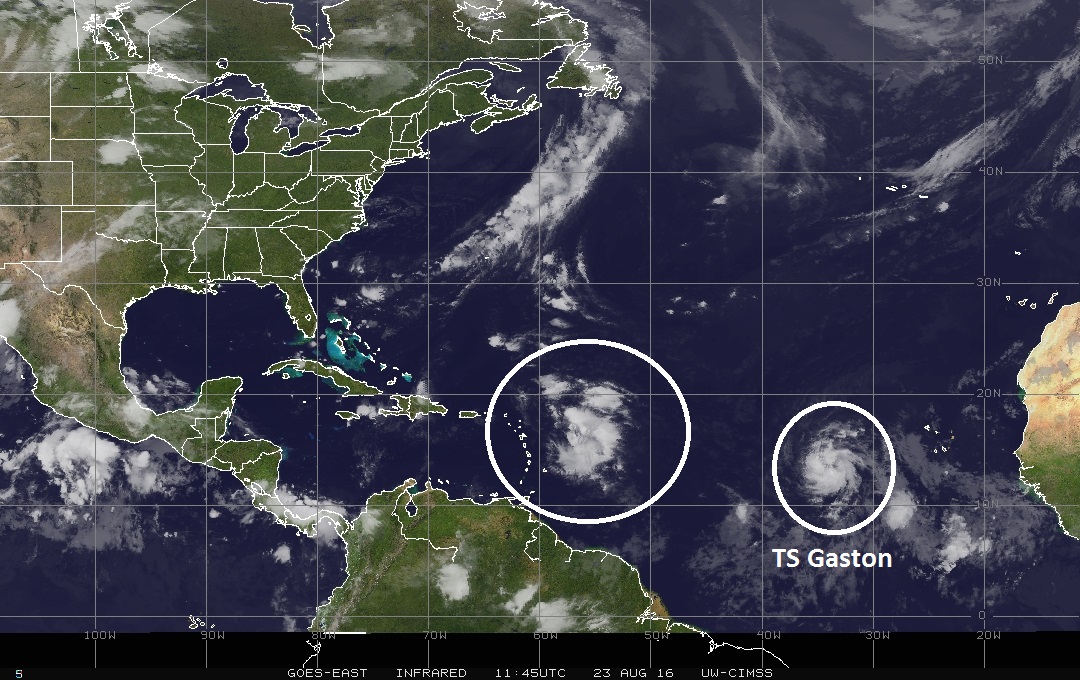
Amazingly, the state of Florida has not had a hurricane of any intensity since Wilma came ashore in southwestern Florida during late October of 2005. Hurricane Wilma was also the last major hurricane (i.e., category 3, 4 or 5) to strike US soil in what has turned out to be another amazing streak. As the climatological peak of the Atlantic Basin hurricane season approaches (mid-September), we now have quite an active scene with three different tropical systems. Tropical Depression Fiona is in a weakening state (at least for now) and it should have little or no impact on the US over the next couple of days. Tropical Storm Gaston is situated in the far eastern Atlantic Ocean and it will likely strengthen significantly over the next few days as it heads in a general northwest fashion, but it is likely to never reach the US coastline before it curves towards the northern Atlantic. And then there is the third system - which is yet to be named - currently sitting a few hundred miles east of the Leeward Islands. It is this system that has a good chance of intensification over the next few days (would become named Hermine), and it has a chance to end the hurricane drought in Florida by the early part of next week.
IR satellite image of the tropical Atlantic Ocean with area of interest circled near the Leeward Islands and Tropical Storm Gaston in the far eastern Atlantic; image courtesy University of Wisconsin/CIMSS
Discussion
A large area of showers and thunderstorms is sitting a few hundred miles east of the Leeward Islands and environmental conditions are favorable for intensification over the next few days as it churns west-to-northwest. First of all, this system has “escaped” the large area of Saharan (dry) Desert air that currently resides in the area much closer to the west coast of Africa (image below). In other words, this tropical wave is entering an area of higher water vapor content which is favorable for future development. Second, sea surface temperature anomalies are positive (i.e., warmer-than-normal) throughout the Caribbean Sea, Gulf of Mexico and Bahama Island regions. This is also a favorable factor for intensification of this particular tropical system. "Hurricane hunters" will visit the disturbance later today shedding more light on its prospects for development. By the way, the last August hurricane to strike Florida was Katrina in 2005.
Compilation of predicted storm tracks from numerous computer models with general agreement that Florida could be visited by "Hermine"; courtesy UCAR, NCAR, NOAA/NCEP
Current computer model forecasts strongly suggest a track for this system of skirting the northern Caribbean Islands and then closing in on Florida by the latter part of the weekend or the early part of next week. Whether it actually just skirts the northern Caribbean Islands is crucial since a little shift to the south of that predicted track could place the system over Hispaniola at some point in the near future and that island's mountainous terrain could do a number on it. Ultimately, some model forecasts indicate that the tropical system could spill out over the Gulf of Mexico after crossing the state of Florida. If this were to happen, additional intensification would be likely given the above-normal sea surface temperatures of the Gulf of Mexico - perhaps even into major hurricane status.
The Hurricane Weather Research and Forecasting (HWRF) model is a specialized version of the Weather Research and Forecasting (WRF) model and is used by NOAA to forecast the track and intensity of tropical cyclones. The HWRF forecast map (top) for late Saturday night is rather ominous looking for the Bahamas and the state of Florida. However, it should be pointed out that NOAA's operational Global Forecast System (GFS) model is far less threatening for the Southeast US than the HWRF.
Dry (Saharan Desert) air (orange) off west coast of Africa; map courtesy University of Wisconsin/CIMSS
Stay tuned.
Sea surface temperature anomalies with warmer-than-normal conditions dominating the entire region (yellow, orange); courtesy NOAA
Meteorologist Paul Dorian
Vencore, Inc.


