10:20 AM | *Florida/Gulf of Mexico in the crosshairs of tropical system, but questions remain*
Paul Dorian

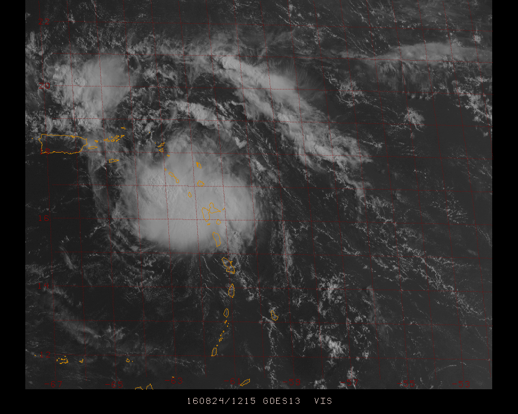
Morning GOES visible satellite image look at tropical system "99L"; courtesy Penn State eWall, NOAA
Overview
Amazingly, the state of Florida has not had a hurricane of any intensity since Wilma came ashore in southwestern Florida during late October of 2005. Hurricane Wilma was also the last major hurricane (i.e., category 3, 4 or 5) to strike US soil in what has turned out to be another amazing streak. Both of these streaks are unprecedented in the record-keeping era and there is a chance that one or both come to an end in the next week or so.

Current steering winds in the lower and middle parts of the atmosphere which favor a movement towards Florida and the Gulf of Mexico; map courtesy University of Wisconsin/CIMSS
Discussion
As the climatological peak of the Atlantic Basin hurricane season approaches (i.e., mid-September), we have an active scene with two different tropical systems. In the eastern Atlantic Ocean, Tropical Storm Gaston has maximum sustained winds of 70 mph and could reach hurricane status later today. It is moving west-northwest at 17 mph towards the open Atlantic and should stay out-to-sea and not impact the US. Meanwhile, the real area of concern is a broad area of low pressure at the northeastern corner of the Caribbean Sea still officially known as 99L (it’ll become “Hermine” when it reaches tropical storm status). This tropical system is now over the northern Leeward Islands and it is showing more organization today as it churns west-northwest around 15 mph towards Puerto Rico, Hispaniola and the Bahamas. There is potential that this tropical system will have an impact on Florida and the Gulf of Mexico region later this weekend and then into next week.
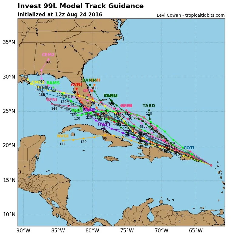
Predicted storm tracks by multiple computer forecast models; map courtesy tropicaltidbits.com, NOAA
Outlook
Current steering winds in the atmosphere suggest this tropical wave will continue on a west-to-northwest track over the next few days and computer forecast models tend to agree (above). This type of near-term wind flow will likely steer this storm at or just to the north of Puerto Rico, Hispaniola, and then into the Bahama Island region. This tropical system is also likely to intensify as it heads over the warmer-than-normal waters in the northern Caribbean Sea and the western Atlantic Ocean.

Topographic map of Hispaniola showing mountainous regions; map courtesy Google
While odds favor a move just to the north of Hispaniola (Haiti/Dominican Republic), a slight shift in that thinking to the south would be important as the mountainous terrain on that island (above) could slow down its intensification or even break it apart into a disorganized area of showers and thunderstorms - at least temporarily. However, assuming it holds together after its encounter with Hispaniola, the tropical system would likely intensify as it approaches the Bahamas and ultimately, the southern part of Florida. In that case, it would be possible that a tropical storm or even the first hurricane since Wilma (October 2005) makes landfall somewhere in southern Florida by the latter part of the weekend - and this would end the state’s unprecedented hurricane drought.

Sea surface temperatures in the western Atlantic Ocean, Gulf of Mexico, and Caribbean Sea (brown areas are greater than 86°F); map courtesy Weather Bell Analytics
After potential landfall in southern Florida by the latter part of the weekend, there are reasons to believe that steering winds will continue to favor a move across the state and into the Gulf of Mexico and some computer models agree with this scenario (e.g., Euro, NOAA's HWRF). Strong high pressure will be situated over the Northeast US by the latter part of the weekend and this position favors movement of any tropical system into the Gulf of Mexico - and not an immediate turn up the eastern seaboard.

NOAA's high-resolution hurricane forecast model (HWRF) prediction for late Sunday night; map courtesy tropicaltidbits.com, NOAA
This type of overall weather pattern is worrisome since it would contribute to low-level convergence over the Gulf of Mexico and combine that with the very warm waters and the result could very well be significant intensification. In a large part of the Gulf of Mexico sea surface temperatures are above 86°F and this would be quite favorable for rapid intensification. Ultimately, it is possible that this tropical system could end up slamming into the region along the northern Gulf coast - perhaps even as a major hurricane. Beyond that, this tropical system could actually end up producing heavy rainfall in parts of the eastern US as it ultimately should curve to the northeast.
Stay tuned, this is still several days away and small changes can have big impacts.
Meteorologist Paul Dorian
Vencore, Inc.