3:00 PM | *Hurricane threat for the Caribbean Sea*
Paul Dorian
NOAA's 12Z Hurricane Weather Research and Forecasting (HWRF) forecast map for early Saturday afternoon; map courtesy tropicaltidbits, NOAA
Overview
It is now known officially as Invest 97L, but it soon could become “Matthew” and it is likely to head into the Caribbean Sea over the next few days and it will have to be monitored closely not only in that region, but also from the northern coast of South America to the Gulf of Mexico and eastern US. While currently this system is just an area of showers and thunderstorms, environmental conditions will become favorable for it to attain tropical depression status in the short term – and then potentially major hurricane status by the weekend in the Caribbean Sea.
Madden-Julian Oscillation (MJO) index forecast maps for the period of September 26 to October 11 (based on NOAA GFS model) with favorable areas for tropical formation/intensification indicated in green.
Favorable factors
There are numerous favorable factors for Invest 97L to intensify over the next several days. To begin, sea surface temperatures in the Caribbean Sea continue to run at above-normal levels and this type of temperature pattern is certainly conducive to development. Second, an index value called the "Madden-Julian Oscillation (MJO)" becomes quite favorable for tropical formation/intensification in the Caribbean Sea region by the time this weekend rolls around. The MJO is a tropical disturbance that propagates eastward around the global tropics with a cycle on the order of 30-60 days. It is a large-scale coupling between atmospheric circulation and tropical deep convection. The MJO has wide ranging impacts on the patterns of tropical and extratropical precipitation, atmospheric circulation, and surface temperature around the global tropics and subtropics. The MJO forecast map above based on the NOAA GFS computer model shows favorable areas (indicated by green) for the early part of October in the Caribbean Sea region.
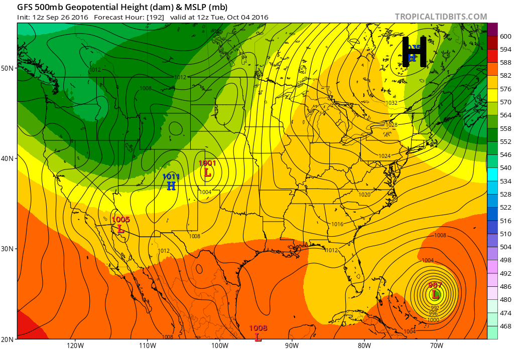
12Z GFS forecast map for next Tuesday morning, October 4th, which features strong high pressure across southeastern Canada. This kind of pattern is always a cause for concern in the eastern US during this time of the tropical season; map courtesy tropicaltidbits.com, NOAA
The Hurricane Weather Research and Forecasting (HWRF) model is a specialized version of the Weather Research and Forecasting (WRF) model and is used by NOAA to forecast the track and intensity of tropical cyclones. The HWRF forecast map for late Saturday is very ominous looking for the Caribbean Sea with a predicted central pressure of 943 millibars (equivalent to 27.85 inches). By Saturday afternoon, the HWRF model has the tropical system over the warm waters of the Caribbean Sea situated south of the Dominican Republic and southwest of Puerto Rico. There is an outside chance that it continues westward at this point and slams into the northern coast of South America; however, should it begin to turn to the northwest or north then all eyes in the Southeast US/Gulf of Mexico regions should focus on "Matthew".
Above-normal sea surface temperatures in the Caribbean Sea and Gulf of Mexico
Next week’s overall upper-level pattern across the US and southeastern Canada will be a cause of concern as strong high pressure will be forming over southeastern Canada. That kind of pattern often spells trouble for the eastern US this time of year in the heart of the tropical season. Needless to say, given the prospects for a potential major hurricane in the Caribbean Sea this weekend and an upper air pattern featuring strong high pressure to the north of here early-to-mid next week, this is a storm that will need to be monitored closely over the next several days from South America to the eastern US.
Stay tuned.
Meteorologist Paul Dorian
Vencore, Inc.


