2:25 PM | *Two big weather stories: 1) hurricane threat continues for the Caribbean Sea and 2) an "atmospheric firehose" setting up for much of the Mid-Atlantic region*
Paul Dorian
12Z GFS forecast map of total rainfall amounts in inches between today and early Saturday; map courtesy tropicaltidbits.com, NOAA
Overview
There are two big stories in the world of weather and both are covered in this discussion. First, an extended and significant rain event is headed to much of the Mid-Atlantic region for the period of late tomorrow into Saturday with the heaviest rain likely centered on tomorrow night into Thursday night. Some areas of the Mid-Atlantic region can end up with five inches of rain or more by the time the weekend begins. The second big story is the likelihood for a hurricane this weekend in the Caribbean Sea. In fact, the tropical system still known officially as Invest 97L could become a major hurricane at some point while moving westward over the warm Caribbean Sea waters. At some point early next week, this system is likely to take a turn towards the north or northwest and it could threaten anywhere from the Gulf of Mexico to the US east coast - but those details will have to wait.
12Z GFS forecast map of 500 mb height anomalies on Thursday AM (left) and Saturday AM (right) showing very little movement of a strong upper-level low; maps courtesy tropicaltidbits.com, NOAA
Significant rain event for the Mid-Atlantic
Ingredients are coming together for a significant and long-lasting rain event for much of the Mid-Atlantic region with several inches of rainfall on the table for hardest hit areas. Strong low pressure in the upper atmosphere (500 mb) will drop southward from the Great Lakes region at mid-week and end up in the Tennessee Valley where it will slow down to a halt as it gets cut off from steering currents aloft. The 12Z GFS forecast map at 500 mb (above) shows very little change in location between Thursday AM and Saturday AM. As a result of its strength and slow movement, this vigorous upper-level low pressure system will be able to pull in a lot of moisture from the Atlantic Ocean over an extended period of time. The main area of concern for potential flooding rainfall is in the area from central Virginia to southern Pennsylvania; especially, in higher elevation locations where upsloping of easterly winds could enhance rainfall amounts. The 12Z GFS forecast of total rainfall amounts places the "bullseye" just to the east of the District of Columbia (e.g., Crofton, MD, Annapolis, MD). Of the three big cities in the DC-to-Philly-to-NYC corridor, the DC metro region may be most vulnerable for the heaviest rainfall in this unfolding scenario.
Latest visible satellite image of "Invest 97L"; image courtesy Penn State eWall, NOAA/GOES
Soon-to-be-“Matthew”
Invest 97L has not attained tropical depression status yet, but that could change over the next 12 hours or so. In fact, the latest visible satellite image shows more of a circular cloud pattern compared to yesterday suggesting some intensification is now underway. There are numerous favorable factors for Invest 97L to intensify over the next few days – perhaps even into major hurricane status by the weekend.
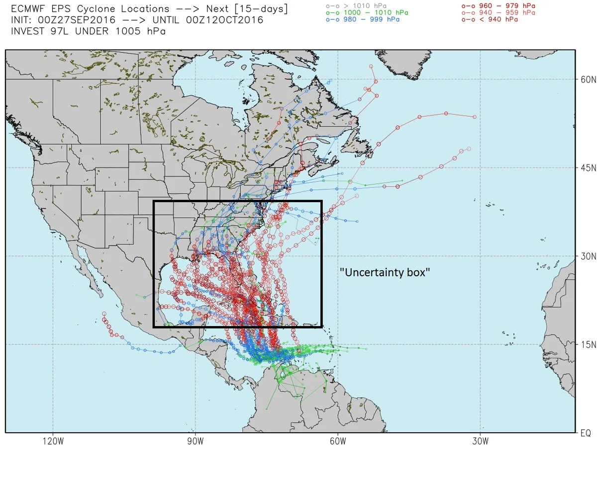
00Z Euro model forecast types of potential cyclone locations for Invest 97L over the next several days. While there is much agreement on its short-term movement into the Caribbean Sea, there is some disagreement in the model on its movement next week. [map courtesy Weather Bell Analytics)
By early next week, this system is likely to begin to turn from its current westward movement to the northwest or north, but it is too early to tell if that turn would ultimately cause an impact on the Gulf of Mexico, US east coast or perhaps even keep it harmlessly east of the US coastline. Last night’s Euro model forecast map for Invest 97L storm tracks agree on pushing the system westward into the Caribbean Sea in the short-term; however, next week’s storm tracks are all over the place from the Gulf of Mexico to the US east coast to even a potential “out-to-sea” solution. Stay tuned, this tropical wave will become named Matthew.
Meteorologist Paul Dorian
Vencore, Inc.


