12:15 PM | ***Significant rain event continues in the Mid-Atlantic region…Matthew on the doorstep of hurricane status***
Paul Dorian
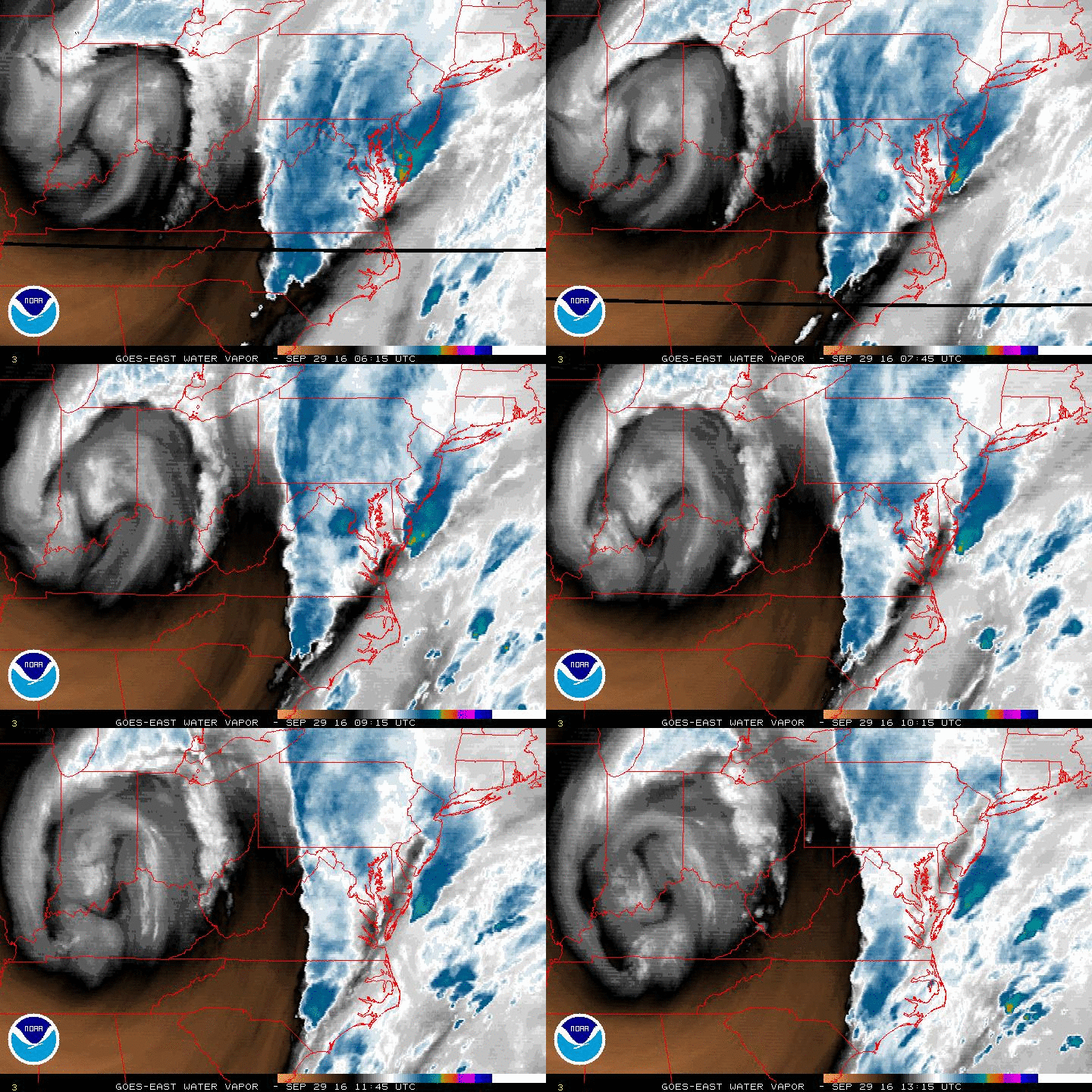
Colorized water vapor imagery loop showing deep upper-level low spinning over the Ohio Valley (white/gray) and moisture surging northward into the Mid-Atlantic (blue); image loop courtesy NOAA/GOES
Overview
The significant rain event that began last night in the Mid-Atlantic region will continue into the weekend and hardest hit areas could end up with several inches. Overnight rain was heaviest in the DC metro region where around two inches fell and flash flooding is a concern there for the next couple of days. In addition, those flash flooding concerns extend from the DC area eastward to the Delmarva Peninsula and New Jersey coastline and northward into southern Pennsylvania. Meanwhile, Tropical Storm Matthew continues to churn westward in the Caribbean Sea and it is likely to become classified as a hurricane shortly and perhaps could reach major hurricane status over the weekend. Later this weekend or early next week, Matthew is likely to make a sharp right turn and heads towards Cuba or Hispaniola. After that, there are a wide range of possibilities ranging from a direct hit on the US to an "out-to-sea" solution - all eyes in the eastern US should continue to monitor this intensifying storm.
Latest GOES visible satellite image of Tropical Storm Matthew; image courtesy Penn State eWall
Significant rain event for the Mid-Atlantic
A deep and slow-moving upper-level low over the Ohio Valley is helping to surge moisture into the Mid-Atlantic region from the Southeast US and off the Atlantic Ocean and this pattern will continue right into the weekend. The latest colorized water vapor imagery loop shows quite well the spinning of the upper-level low over the Ohio Valley and the surge of moisture from the southern states into the Mid-Atlantic. Some heavy rainfall fell last night in the central Mid-Atlantic and there will be occasional heavy rainfall throughout the Mid-Atlantic region during the next 36 to 48 hours or so including around the Philly and DC metro regions. Persistent east-to-northeast winds in the low-levels of the atmosphere will enhance rainfall amounts at higher elevations locations in the region from central Virginia to central Pennsylvania due to upsloping effects. The weekend will certainly start off quite damp with mostly cloudy skies on Saturday and the threat for continuing showers and Sunday cannot be declared completely rainfree either. Genuine clearing may not take place in the Mid-Atlantic region until the early part of next week.
Big differences in timing of Matthew between last night's GFS and Euro highlight uncertainties beyond five days or so
Tropical Storm Matthew
The latest readings on Matthew suggest it could attain hurricane status as early as later today. Maximum sustained winds are now measured at 70 mph which is quite close to the threshold needed for hurricane declaration (74 mph) and satellite imagery is showing a well-organized system. TS Matthew will continue on a westward track over the next couple of days and it could intensify into major hurricane status (i.e., category 3, 4 or 5). Late in the weekend or early next week, Matthew is likely to make a sharp right turn similar to what Hurricane Hazel did back in October of 1954. That sudden shift in direction will likely initially take it over eastern Cuba or perhaps a little farther to the east near the island of Hispaniola.
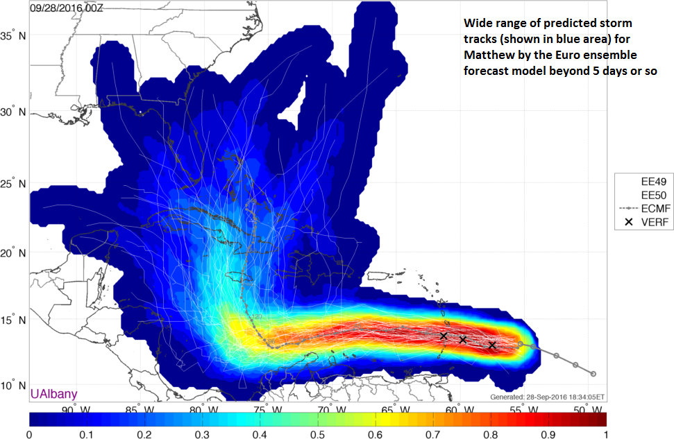
Wide range of possible storm tracks for Matthew within the 00Z Euro ensemble forecast model of 50 members. This suggests the storm track by the 00Z operational version of the Euro is a low confidence forecast and it could change significantly in subsequent model runs.; map courtesy University of Albany
After that, there are a wide range of possibilities and lots of questions still to be answered. Odds favor slow movement of Matthew well into next week and it is possible that it will only move to the Bahama Islands chain by late next week. Model disagreements are quite dramatic between NOAA’s 00Z GFS and the 00Z European which highlights the uncertainty of storm tracks for Matthew beyond five days or so. Last night’s GFS was much quicker than the Euro in its movement of Matthew and also much more threatening to the US east coast. The Euro model itself is showing lots of uncertainty in the longer term as the multitude of its own ensemble members (slightly different inputs) show a wide range of predicted storms tracks (in blue area above) that extend all the way from the Gulf of Mexico to the western Atlantic Ocean. One final bit of hopeful information, from a climatological point of view, odds are against the landfall of a major hurricane north of Georgia this late in the tropical season as that has only happened twice since 1900 (Hazel in 1954, Gracie in 1959).
Stay tuned.
Meteorologist Paul Dorian
Vencore, Inc.
Video discussion:


