2:00 PM | *Matthew now a major hurricane*
Paul Dorian
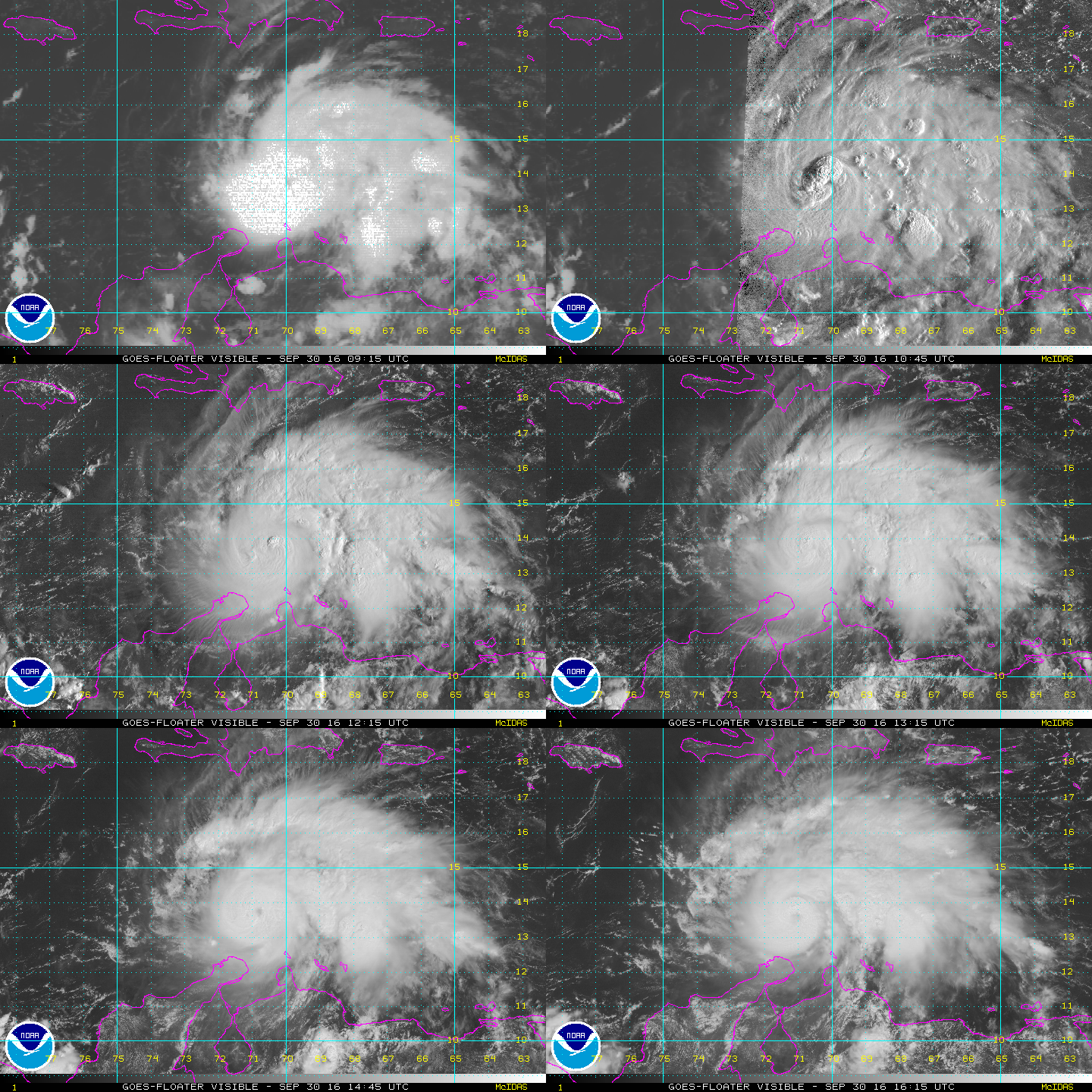
Visible imagery loop of Hurricane Mattherw with a developing "eye"; courtesy NOAA
Matthew has intensified rapidly over the last several hours and is now classified as a major (category 3) hurricane. Matthew becomes the sixth major hurricane in the Caribbean Sea during the month of September since 1990 (Luis, Marilyn 1995, Georges 1998, Ivan 2004, Felix 2007). The latest measured maximum sustained winds of Matthew are 115 mph, central pressure has dropped to 968 millibars, and it is moving WSW at 12 mph. Matthew should continue to move on a general WSW-to-W track during the next 12 hours or so and then make a right turn later in the weekend. By Monday, the island of Jamaica could take a direct hit by Matthew and then the region from central Cuba to Haiti could be directly impacted as Matthew churns slowly to the north.
Sea surface temperature anomalies generally show warmer-than-normal conditions in the Caribbean Sea and western Atlantic Ocean; map courtesy tropicaltidbits.com
Next in line for major impact by Matthew would be the Bahama Island chain during the early and middle parts of next week. After that, the exact track of Matthew remains uncertain; however, there are signs that it could brush the North Carolina coastline or just miss to the east and then gradually turn northeast and away from the Mid-Atlantic coast – but this is still uncertain and too close for comfort. There has not been a major hurricane hit on US soil since October 2005 when Wilma came ashore as a category 3 hurricane in southwestern Florida and this is an unprecedented streak without major hurricane hits since record-keeping began in the middle 1800’s.
European ensemble member predictions of storm track of Matthew; map courtesy Weather Bell Analytics
The latest visible satellite image loop is showing a developing eye as intensification continues despite some wind shear in the general region. Because of the moderately strong wind shear, many of the thunderstorms are displaced to the east of the main area of low-level circulation near the developing eye. This wind shear could inhibit further strengthening in the short-term; however, it is expected to relax later in the weekend. Sea surface temperature anomalies show generally favorable warmer-than-normal conditions throughout the Caribbean Sea and western Atlantic Ocean. By the early part of next week, Matthew is likely to go over land such as central or eastern Cuba and these mountainous areas will typically cause noticeable weakening of a given tropical system.
GFS ensemble member predictions of storm track of Matthew; map courtesy Weather Bell Analytics
As far as computer models are concerned, the European model has been considerably slower than recent runs of NOAA’s GFS, but the very latest GFS tends to slow down in its forward motion of Matthew – more like the recent Euro runs. Both models run an “ensemble” version of the operational model featuring a variety of slight changes to the initialization data in order get a better idea of the range of possible solutions. The GFS ensemble run (20 members) are more clustered with their predicted storm tracks near the Southeast US coastline later next week while the Euro ensemble run (50 members) has been more spread out with some predicted storm tracks as far west as the Gulf of Mexico. [Note – the storm track of the operational version of the given model is shown in blue; storm track of the mean of all ensemble members is shown in black]. There is general agreement that Hurricane Matthew will head right over the Bahama Island chain and it becomes more uncertain. Odds favor a turn to the northeast after a brush with the North Carolina coast which would keep it away from the Mid-Atlantic coast, but it is still not set in stone.
Bottom line - all eyes in the eastern US from Florida to Maine should continue to monitor this system closely.
Meteorologist Paul Dorian
Vencore, Inc.


