3:20 PM | *Major (rain) storm potential for the Mid-Atlantic region early next week*
Paul Dorian
12Z Canadian forecast map of 500 mb height anomalies for next Monday morning; courtesy tropicatidbits.com
Overview
Our “January thaw” will continue into next week with temperatures generally running at above-normal levels, but this period will be accompanied by more rainfall. The next shot at rain comes late Friday into Friday night from moisture pushing to the northeast from the Southeast US. Following that, there are increasing signs for a major storm to head into the Mid-Atlantic region from the Southeast US during the late Sunday into Tuesday time period and it is likely to bring substantial rainfall to the area.
12Z Canadian model forecast map at the surface for Sunday evening; courtesy tropicaltidbits.com
Details
A deep upper-level trough will develop across the SE US by early next week and this will set off the formation of a strong and slow-moving surface low pressure system. The combination of strong upward motion associated with the deep upper-level trough, copious amounts of moisture streaming out of the Gulf of Mexico and western Atlantic, and slow movement will likely result in some serious rainfall around here from later Sunday into Tuesday. In addition, there can be some severe weather to worry about in the SE US and perhaps event parts of the Mid-Atlantic region as this system moves slowly up the eastern seaboard.
12Z Canadian model forecast at the surface for early Monday afternoon showing the slow movement of the Mid-Atlantic low; courtesy tropicaltidbits.com
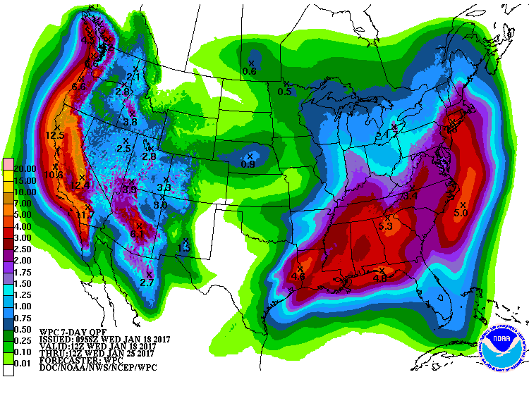
While the first half of next week looks quite mild, there will be big changes unfolding in the upper atmosphere that will bring about colder weather for the eastern US by the end of next week [video discussion below focuses on those changes]. The NOAA forecast of accumulated rainfall over the next 7 days (below) includes the heavy rainfall in the Mid-Atlantic region from this potential early week major storm, and also take a look at California - so much for their drought.
NOAA's forecast map of total precipitation amounts over the next 7 days
Meteorologist Paul Dorian
Vencore, Inc.
vencoreweather.com


