2:25 PM | *Gulf of Mexico likely to feature a tropical storm or hurricane this weekend*
Paul Dorian
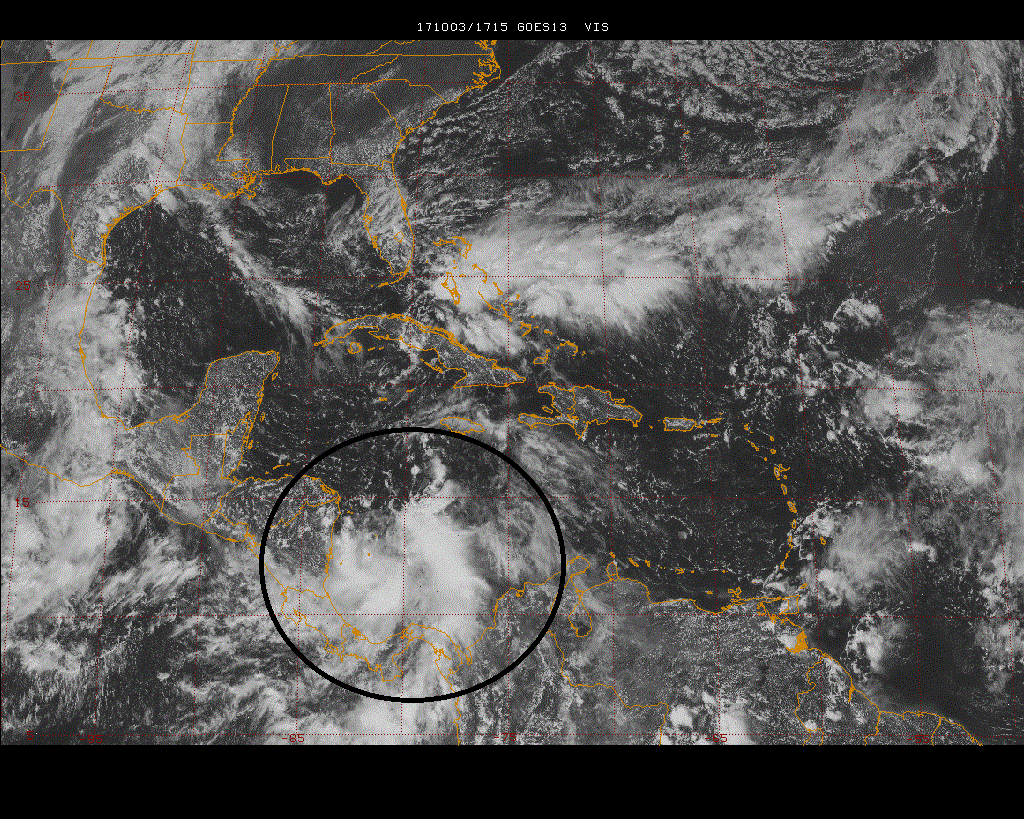
The latest visible satellite image shows an impressive area of thick clouds over the southwestern Caribbean Sea (circled region). This area of interest could very well result in a tropical storm over the Gulf of Mexico by later in the weekend. Image courtesy Penn State eWall, NOAA/GOES
Overview
The Atlantic Basin tropical season has undergone a relatively quiet spell in recent days, but there are signs that this break will end shortly. An area of showers and thunderstorms has now formed over the southwestern Caribbean Sea and environmental conditions are likely to become quite favorable over the next few days for this to become a tropical depression. In fact, by later in the weekend, we could be dealing with a tropical storm or hurricane somewhere over the central Gulf of Mexico. In addition, there are signs that point to tropical moisture from this system to ride up northeastward through the eastern states on an inland track which would actually be welcome news in the Mid-Atlantic region which has been very dry in recent weeks.
12Z Euro forecast map for Sunday morning, October 8th, featuring a strong tropical system over the north-central Gulf of Mexico; map courtesy tropicaltidbits.com
Discussion
The latest visible satellite image shows an impressive area of thick clouds tucked away in the southwestern Caribbean Sea (circled region) and atmospheric conditions are quite favorable for some development over the next few days. This system is likely to reach tropical depression status within the next couple of days as it drifts northwestward and then it could reach tropical storm or hurricane status this weekend somewhere over the central Gulf of Mexico (system would be named "Nate"). This unfolding scenario with a “home-grown” type of tropical system is not uncommon for the latter stages of the Atlantic Basin tropical season and the Gulf of Mexico and Caribbean Sea regions are likely to be areas of keen interest over the next few weeks as opposed to the eastern Atlantic Ocean near the African west coast.
12Z Euro forecast map for Tuesday morning, October 10th, featuring a strong tropical system over the Mid-Atlantic region; map courtesy tropicaltidbits.com
Once this system enters the Gulf of Mexico, signs point to a general northward movement - perhaps right towards the panhandle region of Florida. After that, there is the chance that this tropical system will move northeastward up through the eastern states on an inland track during the early part of next week. This potential scenario would actually be welcome news in the Mid-Atlantic region where it has been quite dry in recent weeks.
Meteorologist Paul Dorian
Vencore, Inc.
vencoreweather.com
Wednesday morning video discussion:


