12:00 PM | *Gulf of Mexico hurricane threat continues for this weekend*
Paul Dorian

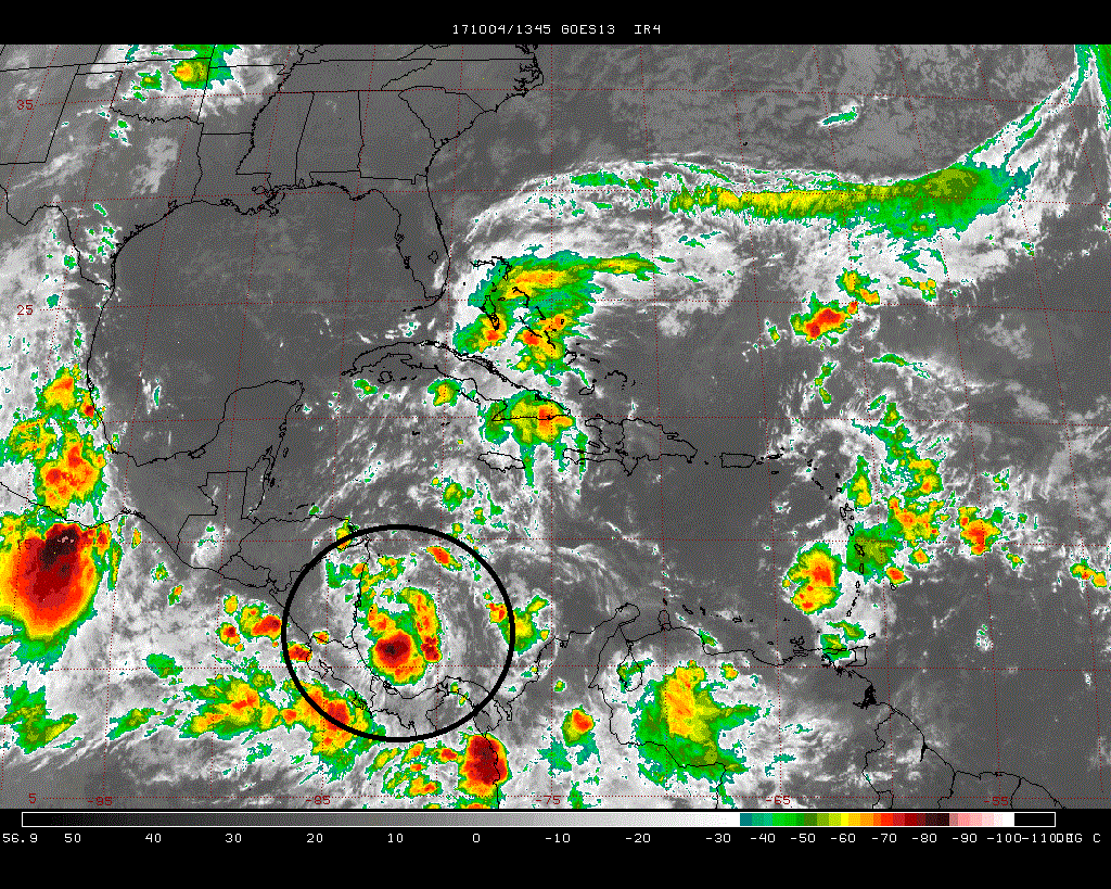
An area of showers and thunderstorms in the southwestern Caribbean Sea (circled region) is likely to develop into Tropical Storm Nate over the next 24 hours or so and it very well could become a hurricane by the weekend over the Gulf of Mexico; image courtesy Penn State eWall, NOAA/GOES
Overview
The Atlantic Basin tropical season has undergone a relatively quiet spell in recent days, but that is about to come to an end. An area of showers and thunderstorms has become better organized over the southwestern Caribbean Sea and it is now officially known as “Tropical Depression 16”. Environmental conditions are quite favorable for this to become a tropical storm within the next 24 hours or so and, if so, it would become named “Nate” by NOAA’s National Hurricane Center. By early in the weekend, we could be dealing with a hurricane somewhere over the central/eastern Gulf of Mexico and it could approach the panhandle of Florida by late in the weekend. After that, there are signs that this tropical system will push northeastward and ride up through the eastern states early next week on an inland track.

00Z Euro forecast map for Saturday evening with "Nate" over the Gulf of Mexico; map courtesy tropicaltidbits.com
Discussion
As of 11 am, “Tropical Depression 16” has max sustained winds of 35 mph and is drifting northwest at 7 mph. The latest IR satellite image shows an impressive area of clouds tucked away in the southwestern Caribbean Sea (circled region) and environmental conditions are quite favorable for further development over the next day or so and tropical storm status is likely to be reached. One such favorable factor for additional intensification involves the sea surface temperatures in both the Caribbean Sea and Gulf of Mexico - both warmer-than-normal. This system is likely to push over the eastern parts of Honduras and Nicaragua over the next couple of days and then skirt the Yucatan Peninsula region of Mexico before heading into the Gulf of Mexico.

00Z Euro forecast map for Monday evening with remains of "Nate" over the Carolinas; map courtesy tropicaltidbits.com
Once this system enters the Gulf of Mexico, signs point to a general north-to-northeast movement - perhaps right towards the panhandle region of Florida – and it could very well reach category 1 or 2 hurricane status. Beyond that, there is a good chance that this tropical system will move northeastward up through the eastern states during the early part of next week on an inland track. This potential scenario would actually be welcome news in the Mid-Atlantic region where it has been quite dry in recent weeks. This unfolding scenario with a “home-grown” type of tropical system is not uncommon for the latter stages of the Atlantic Basin tropical season and the Gulf of Mexico and Caribbean Sea regions are likely to continue to be of keen interest over the next few weeks.

Warmer-than-normal sea surface temperatures currently in the Caribbean Sea and Gulf of Mexico (yellow, orange regions); map courtesy NOAA
Meteorologist Paul Dorian
Vencore, Inc.
vencoreweather.com
Detailed video discussion on the tropical threat: