10:15 AM | *Impressive cold continues on Greenland with high snow/ice buildup… significant growth in the Petermann Glacier during the last five years*
Paul Dorian
Growth of Greenland's Petermann Glacier during the past five years as revealed by NASA/MODIS satellite imagery from a low point in August 2012 (left) to August 2017 (right)
Overview
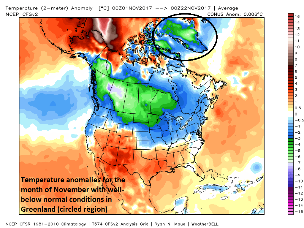
While we are celebrating a chilly Thanksgiving Day in the Mid-Atlantic region, Summit Station in Greenland will experience high temperatures around -40°F which continues the very cold and well-below normal trend for the month of November. Summit Station (also known as Summit Camp) is a high-altitude (10,551 feet) year-round research station in central Greenland and its exact coordinates actually can change since the ice sheet underneath is often on the move. In addition to the bitter cold, snow and ice accumulation throughout Greenland has been running at the high end of normal since the fall of 2016 - at times at or near record levels - and NASA/MODIS satellite imagery reveals significant growth in the Petermann Glacier from a low point reached five years ago. One of the important reasons for closely monitoring the snow and ice buildup on Greenland is that this region can be an important cold air source for the central and eastern US during the upcoming winter season.
The accumulated surface mass balance from September 1st to now (blue line, Gt) and the season 2011-12 (red) which had very high summer melt in Greenland. For comparison, the mean curve from the period 1981-2010 is shown (dark grey). Courtesy Danish Meteorological Institute
Discussion
The accumulated snow and ice on Greenland has actually run at the high end of normal or even at or near record levels in 2017 and this trend began during the fall season of 2016. It was just five years ago in 2012 (red line on bottom portion of plot) when Greenland experienced unprecedented melting of snow and ice as revealed by satellite imagery. In the next ten days, computer model forecasts are predicting more snow for the region with a foot or more possible across the southern third of Greenland adding to the current high amounts.
Temperature anomalies for the month of November so far featuring much colder-than-normal conditions in Greenland (circled); map courtesy Weather Bell Analytics
Petermann Glacier
Greenland is a massive island country that lies between the Arctic and Atlantic Oceans and is full of dozens of glaciers. The Petermann Glacier is a large one located in the far northwestern part of the country that connects the Greenland ice sheet to the Arctic Ocean near 81 degrees north latitude.
Significant additional snow is expected over Greenland during the next ten days; forecast map courtesy NOAA/EMC/06Z GFS
Given the buildup of snow and ice in the past year or so on Greenland, it may not be too surprising to see an expansion of the Petermann Glacier . As snow accumulates on a glacier, the glacier is pushed by its own weight outward or downward, towards the sea. In fact, this particular glacier has grown by several kilometers during the past five years as revealed by MODIS satellite imagery from its low point in August of 2012 to this past August.
Meteorologist Paul Dorian
Vencore, Inc.
vencoreweather.com


