
2:10 PM | **Southern California to take brunt of intense Pacific Ocean storm next couple days…yet another storm to pound northern California early next week**
Paul Dorian
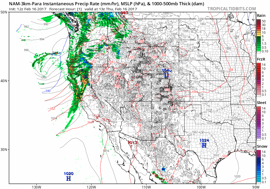
High-resolution (3-km) 12Z NAM-para model run of surface weather conditions for the western US for the next 60 hours (in hourly increments); courtesy tropicaltidbits.com, NOAA/EMC
Overview
The news does not get any better for California. A monster storm will impact the state from late tonight into early Saturday and southern California will take the biggest hit from this system. In fact, this could turn out to be one of the worst storms in years for the southern part of the state with not just the heavy rain, but also wind and possible power outages. In addition, intense rainfall, especially over areas with steep terrain or with recent burn scars, may lead to rapid runoff; resulting in flash flooding and/or mudslides/debris flows. By early next week, yet another Pacific Ocean storm will head towards the state and this one is likely to concentrate its wrath on the northern part of California raising new concerns for the Oroville Dam.

Total precipitation amounts over the next 60 hours as predicted by the high-resolution (3-km) 12Z NAM-para computer forecast model; courtesy tropicatidbits.com, NOAA/EMC
Storm 1 (Late Thursday night into early Saturday)
The latest version of a high-resolution NAM model (3-km) shows the slow progression of an intense Pacific Ocean storm into California over the next 60 hours (loop of surface forecast maps is in hourly increments). Unlike some previous storms, this system will impact the southern part of the state more so than the north and some areas down there can receive upwards of ten inches of rain by the early part of the weekend. In fact, this could turn out to be one of the worst storms in years for the southern part of the state with not just the heavy rain, but also strong winds and possible power outages. In addition, intense rainfall, especially over areas with steep terrain or with recent burn scars, may lead to rapid runoff; resulting in flash flooding and/or mudslides/debris flows. Heavy snow will also fall on Friday/Saturday in the higher elevations of the Sierra Nevada Mountains with more than a foot likely in some spots. The last frame in the 60-hour loop of surface weather conditions is for early Saturday evening and one can see another storm system waiting ominously just upstream (upper, left of last frame in the loop).
Storm 2 (Monday/Tuesday)
On Monday and Tuesday, another powerful storm is likely to approach northern California and that part of the state is liable to receive another several inches of rain. This Monday/Tuesday storm will impact the area around Oroville Dam which has seen lowering water levels during the past couple of days as state officials have drained the reservoir. The lake level fell by nearly 5 feet in the 12-hour period ending at 8 a.m. on Thursday, dropping to below 869 feet. That was about 32 feet below the top of Oroville Dam even as the first in a series of storms hit the Oroville region late Wednesday. Tomorrow’s storm system is likely to generate about an inch or two in the area with much more than that farther to the south across southern California.
One final note, two small earthquakes were recorded near Lake Oroville in the last 24 hrs, which appear to be a result of the fast lake level changes, and the subsequent release of pressure from water weight. The magnitude of the quakes were very small, 0.8 and 1.0 on the Richter Scale, and there does not appear to be any threat to the dam infrastructure.
Meteorologist Paul Dorian
Vencore, Inc.
vencoreweather.com