1:40 PM | *Deadly Hurricane Audrey slammed into SW Louisiana 60 years ago today as the strongest June hurricane to ever make landfall in the US*
Paul Dorian

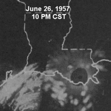
Hourly radar image animation of Hurricane Audrey making landfall in Louisiana
Overview
Nowadays, when the people of New Orleans think of devastating hurricanes they think of Katrina, but before 2005, the most notorious storm name in Louisiana was Audrey. Sixty years ago today, Hurricane Audrey slammed into the southwest coast of Louisiana and became the earliest major hurricane (category 3) to make landfall in the US. Hurricane Audrey killed hundreds of people – estimated to be somewhere between 400 and 500 - including many of whom to this day remain unidentified and tragically, about one-third of those were children. The high number of deaths - in an era without satellite imagery - were attributed to the storm moving ashore earlier and stronger than predicted while most people were sleeping.

Track of Hurricane Audrey which formed on June 25th, 1957 and made landfall on June 27th, 1957
Discussion
Hurricane Audrey was the first named storm of the 1957 Atlantic Basin tropical season. It formed on June 25, 1957 from a tropical wave which moved into the Bay of Campeche where sea surface temperatures were approximately 85 degrees. The tropical system was situated over these very warm waters while very favorable upper-level divergence developed aloft. The result of these favorable conditions was a very quick intensification into hurricane status just hours after being classified as a tropical cyclone. After attaining hurricane status, Audrey continued to strengthen and began to move northward. In fact, Audrey reached category 3 status before making landfall with sustained winds rising to 125 mph and a central pressure that plunged to 946 millibars. The storm surge of Audrey was reported to have peaked as high as 12 feet which inundated coastal areas and damage from the storm surge extended as far as 25 miles inland. Heavy rainfall piled up quickly to amounts over 10 inches in some parts of southern Louisiana.

A man with a wheelbarrow starts to clean up one week after Hurricane Audrey.
Times-Picayune archive
After maintaining its eye 60 miles inland, Audrey weakened and transitioned into an extratropical storm as it turned northeastward over Louisiana. The remains of Audrey caused additional damage and fatalities inland by first generating more than 20 tornadoes across Mississippi and Alabama and then record rainfall in the Midwest. Ultimately, Audrey would even bring torrential rain and strong winds to Canada resulting in 15 deaths across Ontario and Quebec.
The name Audrey was ultimately retired from usage as an identifier for an Atlantic Basin hurricane.
Meteorologist Paul Dorian
Vencore, Inc.
vencoreweather.com