1:00 PM | **Hurricane Harvey closes in on southeast Texas…tremendous rainfall amounts expected over a several day period…second tropical system to ride up along Southeast US coastline**
Paul Dorian

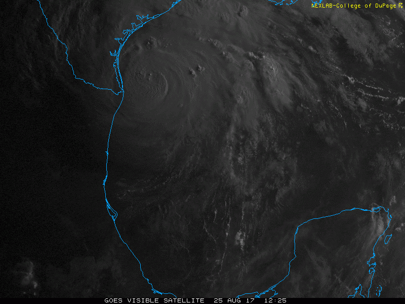
Visible satellite imagery loop of Hurricane Harvey as it approaches the southeastern coastline of Texas; image loop courtesy College of DuPage, NOAA/GOES
Overview
Harvey is now a strong category 2 hurricane and it is closing in on southeastern Texas near Corpus Christi. Hurricane Harvey will come to a grinding halt over the next couple of days and could very well be “forced” to loop back around over the open warm waters of the western Gulf of Mexico due to a roadblock pattern in the upper atmosphere. As a result, there will be several days of torrential rainfall over southeastern Texas and final amounts are likely to be staggering when all is said and done later next week.
Meanwhile, a second tropical system is getting better organized just to the southwest of Florida. This system could strengthen into Tropical Storm “Irma” over the next few days as it churns northeastward along the Southeast US coastline. In fact, “soon-to-be” Irma could reach hurricane status by the time it reaches the region near the Outer Banks of North Carolina and it could end up throwing some rain and wind back into the I-95 corridor during the early part of next week.

Prolonged period of torrential rainfall from Hurricane Harvey will likely result in staggering total amounts; map courtesy Weather Bell Analytics, NOAA
Hurricane Harvey approaches Texas
Hurricane Harvey is a strong category 2 storm at mid-day and it is likely to strengthen additionally over the next few hours – perhaps into category 3 (major) status. Harvey has sustained winds at 110 mph and is currently moving NW at around 10 mph. The hurricane’s exact intensity at landfall (i.e., category 2 or 3 or even an outside chance at 4) will not really matter much in terms of the virtually certain outlook for a prolonged period of torrential rainfall with the possibility of as much as 3 feet to pile up in some parts of Texas. Latest satellite imagery suggests Harvey may be now undergoing an “eyewall replacement” which could result in a temporary decrease in intensity while the overall wind field actually expands in size. During the "eyewall replacement" phase, the inner eye wall decays while the outer eye wall solidifies.
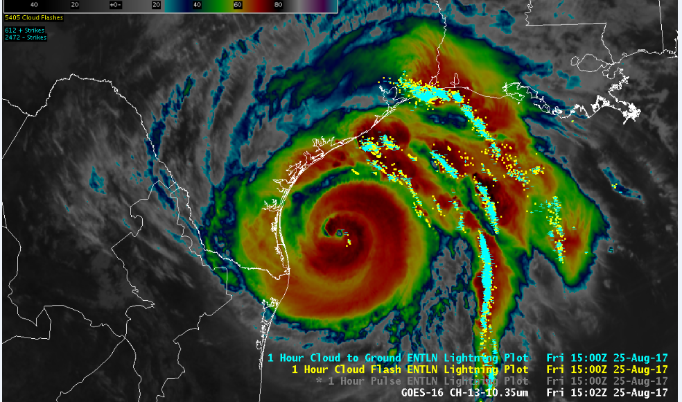
This colorized IR satellite image is infused with lightning data which sheds some light on the areas of strongest convection and upward motion surrounding Hurricane Harvey's eyewall; courtesy NOAA/GOES
In a day or two, Harvey will encounter an environment with weak steering currents sandwiched between a high pressure region over the Gulf of Mexico and another vert strong one over the interior western US. As a result, Harvey is likely to slow down to a crawl after making landfall and it could then do a loop back out over the open water where it would likely strengthen again before possibly making a second landfall sometime later next week in northeastern Texas or southwestern Louisiana.

Latest (still) visible satellite image of the entire Gulf of Mexico shows Hurricane Harvey near Texas (left) and the second tropical system just to the southwest of Florida (center); image courtesy NOAA/GOES
Second tropical system ("92L") now off of SW Florida
An area of heavy showers and strong thunderstorms associated with a tropical wave is currently sitting just to the southwest of Florida. This system is likely to intensify somewhat over the next few days as it begins a slow push to the northeast along the Southeast US coastline. It is entirely possible that this system will become Tropical Storm Irma over the next few days and perhaps even reach hurricane status as it grinds towards the Outer Banks of North Carolina. At that point, it is still unclear as to whether the “soon-to-be” Irma would turn out to sea or perhaps ride up close to the Mid-Atlantic coastline. Indeed, there is the possibility that this system will be close enough to the Mid-Atlantic coastline (and strong enough) to perhaps throw some rain and wind back into the I-95 corridor during the early part of next week.
Stay tuned – the next six weeks or so should be quite an active time period in the Atlantic Basin tropical region.
Meteorologist Paul Dorian
Vencore, Inc.
vencoreweather.com
Extended video discussion on the tropics: