10:40 AM | **Irma continues to track towards the Florida Straits as a very dangerous hurricane**
Paul Dorian

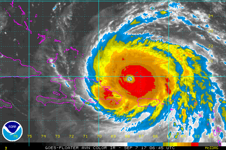
The latest colorized IR satellite imagery loop of Irma; courtesy NOAA
Overview
Irma remains a category 5 “major” hurricane with max sustained winds at around 180 mph. It continues to move on a general WNW track and will likely reach the Florida Straits by the early part of the weekend. Strong high pressure ridging over the central Atlantic continues to steer Irma to the WNW, but an upper-level trough digging into the Northeast US this weekend will allow Irma to turn northward and ride up through the state of Florida.

The mean track of Irma from the 00Z Euro ensemble run is shown in black; courtesy tropicaltidbits.com
Discussion
Irma has a well-defined eye and is a very symmetrical looking system – all signs of a strong storm. Irma is moving over very warm waters of the Atlantic and those favorable conditions will continue in the near term; especially warm water north of Cuba. In addition, dry air from the Saharan Desert is nowhere to be found right now and this too favors Irma to maintain its “major” hurricane status.

Very warm waters in and around the Bahamas are favorable for Irma to maintain "major" hurricane strength over the next few days; map courtesy NASA
As the central Atlantic ridge extends to the southwest, Irma will likely continue on a general WNW track for another 48 hours or so. There is a deep upper-level trough headed towards the Northeast US this weekend, and this feature will allow Irma to take a turn to the north likely resulting in a south-to-north movement over the middle of the state or near the east coast. After Irma's trek over Florida, the center could head right into southern Georgia - possibly even maintaining its strength as a major hurricane. If the storm continues at its current pace, conditions over southern Florida will begin to deteriorate early this weekend and all of Florida must continue to monitor very closely the movement of Irma.
Meteorologist Paul Dorian
Vencore, Inc.
vencoreweather.com
Extended video discussion on Irma: