
11:00 AM Sunday | *Hurricane threat for the northern Gulf region by mid-week…after landfall, soon-to-be "Michael” could spread heavy rainfall up the east coast*
Paul Dorian
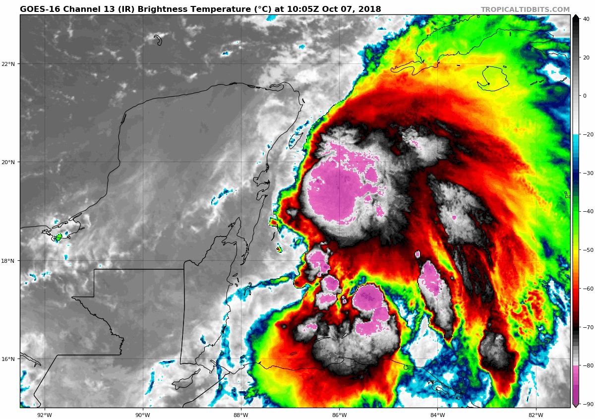
The latest colorized imagery of tropical depression fourteen shows deep convection over the western Caribbean Sea; courtesy NOAA/GOES, tropicaltidbits.com
Overview
Any time the upper-level pattern evolves this time of year to one with very strong high pressure ridging centered over the NE US and SE Canada, it is time to monitor closely the Caribbean Sea and Gulf of Mexico. Indeed, a tropical system that is currently located in the western Caribbean Sea is likely to turn northward over the next couple days and head out over the warm waters of the Gulf of Mexico. This system will perhaps reach Tropical Storm status as “Michael” within the next 24 hours and could threaten the Florida Panhandle as a hurricane by mid-week. Once landfall is made, this system may turn in a northeasterly direction and head up along the eastern seaboard spreading some unwanted heavy rainfall in the Carolinas and perhaps as far north as the Mid-Atlantic late in the week as it interacts with a frontal system.

Details
The latest colorized satellite imagery loop of low pressure centered just off the Yucatan Peninsula region of Mexico shows deep convection and better organization. This system is now strong enough to be labeled as a tropical depression by the National Hurricane Center of NOAA and could very well became Tropical Storm Michael within the next 24 hours or so.

Upper-level pattern is conducive to tropical activity in the Gulf of Mexico and Caribbean Sea; courtesy NOAA, tropicaltidbits.com
This tropical system will likely move generally to the north over the next couple of days and gain speed as it encounters southerly flow of air between high pressure over the western Atlantic and and advancing deep upper-level trough over the western US. Currently, the tropical depression is under the influence of some wind shear, but this condition should lessen over the next couple of days allowing for intensification. In fact, significant intensification is very likely early this week and reaching hurricane status is certainly on the table by Tuesday or so and all eyes from Florida to Louisiana should closely monitor this system; especially, in the Florida Panhandle.

Tremendous rainfall amounts over the next 7 days with tropical system generating an extended swath (boxed region); courtesy NOAA
Once the tropical system makes landfall, it is likely to turn to the northeast and begin to ride up through the eastern states. At the same time a cold frontal system will be arriving in the eastern US and the interaction could result in significant rainfall for places like the Carolinas where they certainly don’t need any. It is still unclear whether the heavy rainfall associated with this tropical system can make it all the way north into the Mid-Atlantic, but it certainly within the realm of possibility at this point for late this week. Following the passage of the tropical system into the open Atlantic, colder air that has been bottled up in Canada in recent days will finally make its way into the NE US.
Meteorologist Paul Dorian
Perspecta, Inc.
perspectaweather.com