11:40 AM | *July likely to begin with strong upper-level ridging over the Northeast US, heat in the I-95 corridor, and the potential for tropical mischief*
Paul Dorian
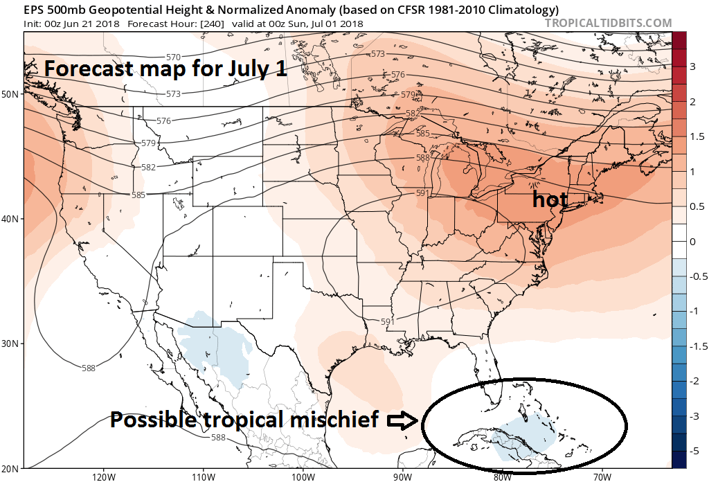
00Z Euro ensemble model forecast map of 500 mb height anomalies on July 1st; courtesy ECMWF, tropicaltidbits.com
Overview
In about ten days, signs point to strong upper-level ridging to be positioned over the Northeast US and this would likely result in above-normal temperatures for the DC-to-Philly-to-NYC-to-Boston corridor as the month of July gets underway. In addition, with upper-level ridging centered over the Northeast US, the chances for tropical mischief will increase from the Caribbean Sea to the Gulf of Mexico. This particular location of upper-level ridging this time of year often leads to low-level convergence in the Atlantic Basin and it promotes the westward movement of tropical waves.
Details
Temperatures are likely to average out rather close-to-normal for late June in the period from today through the middle of next week as high pressure to our north tends to control the pattern. In fact, the first half of next week could very well feature spectacular and very comfortable weather for the Mid-Atlantic region and Northeast US as strong high pressure over the Great Lakes takes firm control of the overall weather pattern. Sunshine should rule each day in the Monday to Wednesday time period and temperatures and humidity levels will be quite comfortable in the I-95 corridor for late June -it’ll be a great time to take a few days off from work.
00Z Euro ensemble model forecast map of 850 mb temperature anomalies on July 1st; courtesy ECMWF, tropicaltidbits.com
Once we get to the latter part of next week, however, the overall weather pattern will change as that same surface high pressure system pushes off the east coast. Upper-level ridging over the Upper Midwest will expand into the Northeast US at the end of next week and this very well could set the stage for a hot stretch of weather in the I-95 corridor as June ends and July begins - perhaps even through the July 4th holiday. The latest Euro ensemble model run features strong ridging centered over the Northeast US in early July and this would generally result in hot weather for the I-95 corridor with highs likely in the 90’s.
In addition to the abnormal ridging over the Northeast US, the ten-day Euro model forecast map of 500 mb height anomalies indicates a bit of a trough (shown in blue) over Cuba and the southwestern Bahamas. This is a important signal that there very well could be tropical mischief in this particular time period which is often correlated quite well with strong ridging centered over the Northeast US. Any tropical system at this point in time is likely to be aided by low-level convergence given the position of the upper-level ridging over the Northeast US and it quite likely to be headed westward – potentially to the Gulf of Mexico. Stay tuned.
Meteorologist Paul Dorian
Perspecta, Inc.
perspectaweather.com


